Friday, November 14, 2014

The density of density: should density be uniform in cities or variable and concentrated?

In an earlier piece, I had explained why density was important, and even used trip survey data in Québec to plot the percentage of trips made by car versus neighborhood density, which  revealed a strong linear relationship between the two:
Auto mode share (y-axis) vs residential density (x-axis, people per square kilometer)
Density is of course measured by the population residing in a given area. However, this obscures a more complex reality of the distribution of density around the area. Two areas can have the same overall density, meaning the same population over the same area, but have wildly different patterns of density: one may be of uniform density over the entire area, with just one type of housing, the other may have great housing variety, with very dense apartment blocs in certain areas and large single-family houses in others.

So, which is better? The uniformly dense city or the unevenly dense city?

A lot of urbanists in North America are very classical, craving order and uniformity, their models are European cities with buildings of the same height built close together. I think the country that exemplifies this best is actually the UK. From what I understand, the UK has a very centrally planned form of urban development, with cities drawing up plans and all developments requiring planning permissions on a case-by-case basis, making planners extremely important and resulting in very similar developments, with a marked preference for semi-detached housing and row houses. Indeed, nearly two thirds of the British population live in such housing, and there is very little multi-family development:
Shares of population living in each dwelling type (RoC=Rest of Canada, apart from Québec)
This mode of development is most flagrant in London where many subway stations are stuck in uniform neighborhoods of row houses without any dense node anywhere. On the other hand, we have the Japanese model which is much more chaotic and tolerant of varied housing types.

For example, here is Sudbury Town station, about 15 km west of London's CBD:

Overhead view of Sudbury Town station, 15 km west of London's CBD
Closer view of station
As you can see from these aerial shots, developments seem planned, with great uniformity in housing stock and seemingly no particularly dense housing, offices or retail near the station itself. In fact, if you were to take the northern exit of the station, here is what you would see:

Google Street View from Sudbury Town station
Housing doesn't vary all that much, with row houses and semi-detached houses being ubiquitous, demonstrating well the bias of British planners towards this type of housing.
This is right next to the station

A bit further out

Still a bit further out
Now let's compare this with Tsutsujigaoka, a Tokyo train station 15 km out west of Tokyo station. It's not technically a subway station, but with trains coming in at headways of 5 minutes all day in both directions, it could as well be.

Overhead view of Tsutsujigaoka station

A closer view of the station and the high-density node around it
I hope you can see clearly how there is significant contrast between areas close to the station and those further out, with 10-story buildings right next to it and largely low-rise areas a bit further away. You can also see in the first pictures what seems to be a danchi (public housing) "village".
View from station's northern exit... contrast with Sudbury Town's
 As to housing, here is some typology of it:
Right next to station, tall condo towers, often with retail on ground floor


Low-rise single-family area away from the station

Just for curiosity's sake, the danchis down south
The British example is much less dense near the station, yet the row houses and semi-detached homes are a bit denser than the single-family areas of the Japanese example.

A thought experiment

Now that I've illustrated the two models, of uniform density and concentrated density, let's do a thought experiment. Let's take two neighborhoods, with a major destination point at the center (retail, transit station, whatever), one of them has uniform density with 2- or 3-story buildings, with 10 000 people per square kilometer (much less in the commercial center) and another with tall condos/apartments in the center, surrounded by lower-density single-family areas. In effect, the density will vary between 30 000 and 6 000 people per square kilometer.

To the left, the uniformly dense neighborhood, to the right, the one with varying density
Both have the same population of about 19 000 people. If you calculated population over the area, you'd conclude that the uniformly dense neighborhood is actually denser, with 9 800 people per square kilometer versus 8 300 for the second. This is how density varies according to distance in the two neighborhoods:
Now let's say I want to predict how likely people are to walk to the center of the neighborhood. Walking, as is instinctively evident, is very sensitive to distance. If you have to go next door, you are going to walk all the time (unless you live in a rural area where the next door is a couple of kilometers away). But as distance increases, the probability of walking decreases quickly. I have tried but failed to find data showcasing walking mode according to distance relevant to this thought experiment, so I just made this curve. NOTE: do not quote me on this curve, I literally pulled it out of my ass, just going by what I think should be true.

Using the two previous graph and the data at their base, I calculated the total probability of walking for the entire population by taking each slice of the neighborhoods and multiplying the population by the probability of walking based on average distance to center. This is what I obtained as a result:

Uniform density: 26% probability of walking to center
Varying density: 36% probability of walking to center

The reason is simple: though overall the second neighborhood is less dense, since it's much denser in the center, more people live really close to the central area than in the uniformly dense neighborhood, where density is even lower in the center than farther out because building height is the same everywhere but retail occupies a large part of the floor area in the center. And since the probability of walking is much higher if distance is smaller, then it's much better if you can get as many people to live as near to the concentration of destinations as possible.
Cumulative population living within distance of center
Note also that the average density I calculated previously was the typical average density, dumbly dividing total population by total area. This is not very representative of the density the average person experiences. It is much better to calculate weighted density. This gives more weight to denser areas. Calculating is means dividing the area into smaller blocks, calculating the density of each of these blocks, multiplying the density by the population, adding all these totals together and dividing by the total number of people.

Visually, it means this: If I plot the density of neighborhoods over the cumulative population of the two neighborhoods:
 ...the weighted density is the value for which the areas between the curve and the value equal out top vs bottom (here, the light blue and dark blue areas both are of the same size).

Doing it this way, the weighted density of the uniformly dense neighborhood is 9 900 per square kilometer, and 10 700 for the neighborhood of varying density. It reverses the previous averaging result, and is a better representation of the average density people live at.

Of course, this works if the higher density areas are near the commercial area/train station/other common destinations of trips. If density varies, but is less near the center and higher at the fringe (like, you know, Radisson station in Montréal), this is far worse than the uniform density case.

And indeed, this impact of density distribution seems to have measurable impacts. Whereas Tokyo's subway lines have respectively riderships of 12 and 8 million riders per km of track, London's Tube only has a ridership of 3 million riders per km of track per year. Another impact is that buses in Tokyo have very low ridership, but in London, since people live on average farther from subway stations due to the absence of high-density multi-family housing near most of them, buses are more used than subways, however bus trips are very short (1,6 mile on average in 2001 according to this data... sounds like a last mile problem).

Conclusion

As the most efficient mode of transport is walking and walking is very distance-sensitive, if we want to maximize the mode share of walking trips, then it is important to be ready to allow higher density developments near popular destinations: offices, groceries, transit stations, etc... The idea of uniform density, if it appeals to some's sense of aesthetics, is not as efficient and it doesn't respond to people's actual desires, with the supply of housing in highly desirable areas being artificially limited to be equal to the supply of housing in undesirable areas of the same size. More efforts should be put towards increasing density significantly near commercial/job/transit nodes rather than increasing the density of all neighborhoods at once.

Wednesday, November 5, 2014

How I Learned to Stop Worrying and Love the Last Mile Problem

Heard of the last mile problem? The last mile problem is a feature of rapid transit, which tends to be expensive and have widely spaced stops, which means that in most cities where rapid transit exists, there will be few areas within easy walking distance of the rapid transit stops. There is then the issue of the last mile of the trip which cannot be done on the rapid transit line but must take some other mode of transport.
The last mile problem: Going from A to B, B is too far from the rapid transit line to be walked to comfortably, needing a modal change
The typical solutions to the last mile problem tend to about trying to accommodate this modal change by making it easier to get to and from the station.

For instance, on commuter rail lines, it is frequent in North America to see huge parking lots right next to the station so that suburban residents can park there and take the train downtown. That way, the "last mile" from low density suburban neighborhoods to the train station is done in a car.
Big park-and-ride lot next to commuter rail station in Blainville, a Montréal suburb (you can see the train at the bottom left)
More frequently, this is done with feeder buses that go around neighborhoods to provide service to plenty of people and take them directly to rapid transit stations:
A bus terminal at Angrignon Station on the Montréal subway
More rarely in North America but common in Japan and the Netherlands is to provide for plenty of bicycle parking so that residents around stations can go there on their bikes.
A 4-story high bike parking garage near Chigasaki station, in the Tokyo area
An advantage I will grant BRT is the ability to offer a "trunk-and-branch" system where buses on the trunk bus lane get off at "stations" and then act like feeder buses. That way, it reduces transfers. However, such a system may be good during peak hours, but less during off-peak hour as the frequency required on each branch may not be the frequency required on the trunk, forcing the transit authority to either run plenty of mostly empty buses on the trunk line (poor vehicle utilization means high operating costs) or reduce frequencies on each route to the point of discouraging taking the bus.
A trunk and branch BRT system with bus routes having "feeder" routes to increase coverage and continuing down the "trunk" of the BRT along a few stations
But let me ask a question here: is the last mile issue really a problem... or is it in reality an opportunity?

The last mile as an opportunity rather than a problem

A few posts back I wrote about what attracted industrial parks and shopping centers to highway interchanges. I said that people who decide where to settle care about a few things:
  1. The catchment area of the location: how many people can reach the place in a short amount of time
  2. The local traffic already present, which is useful to attract attention from passer-bys for whom the marginal cost of going at the location is nearly nil as it's already on the way.
  3. The transport capacity of the network leading to that location, as congested transport links can discourage people from going there
These factors explained why businesses went to highway interchanges when available, the location at highway exits allowed them to maximize the catchment area as plenty of people would be within a short drive from it, thanks to the high speed of highways. As there are only a few exits on highways, it means that there is plenty of local traffic passing through at each interchange, even as highways drain traffic off of commercial streets around. Finally, highways tend to have relatively high capacity per lane.

We can find a nearly perfect analogy here between rapid transit lines and highways... like highways, rapid transit lines are high-speed, high-capacity transport links with limited entry points and exits. Consequently, they draw people to them as people seek to profit from their speed (for transit, speed includes high frequencies which reduce wait times), leading to high concentrations of local traffic at entry and exit points of the line. The speed also allows them to reach a larger area than comparable, slower forms of transport for a given travel time.

Therefore, just like highway interchanges, rapid transit stations are perfect for commercial development. They also satisfy the three criteria of high catchment areas, plenty of local traffic as people get off the rapid transit vehicles then become pedestrians (perfect passersby) and the capacity of the link is incredibly high.

So I realize that: high-density transit-oriented development that concentrates retail, services and jobs at transit stations is the single best solution to the last mile issue.

In fact, the concentration of pedestrians at stations during the modal transfers represents a golden opportunity by creating the conditions for viable high-density, pedestrian-oriented development.

When people want to build pedestrianized areas, there is always the issue of finding places where pedestrian traffic is high enough to support pedestrianization and the retail that one seeks to plan there. Rapid transit actually solves that issue, stations are perfect places to build human-oriented developments because they already represent a waystation to thousands, sometimes tens of thousands, of people each day. This is perfect for specialized stores that require large customer pools to survive. For instance, in Japan, equivalents of Wal-Mart (Ito Yokado and Seiyu stores) and Best Buy (Yamada, Bic Camera, etc...), tend to congregate around train stations. There are some built like American big boxes farther away, but others are built in compact urban forms around train station. These stores require being accessible to plenty of people to survive, and train stations, which are accessible by vast numbers of people and at the center of most local bus lines (that act as feeders to the train station), are perfect locations for them.
Movement patterns in a city with a grid-like street and transit-system, with traffic being spread around and converging on the center of the city, with proximity stores (orange dots) spread around the city and high-density activity centers (red dots) only in the center

With a rapid transit line (in red), movement patterns are shifted to concentrate at stations where high-density activity centers can start growing, which draws even more trips towards the stations, even when there is no intent to actually take the rapid transit line

In other words, the concentration of activity at a few stations, which is the result of the "last mile problem", allows for the creation of a small pedestrianized downtown area at the station itself if developments are allowed and encouraged. This is also good for housing choice, as it allows high-density housing to be grouped near stations, without causing any congestion problem, while leaving lower-density housing further out in sleepy mostly residential areas, within a short bike or bus ride to an active, pedestrian-friendly area, rather than having a mainly uniform urban area. That way, each station can be the center of its very own urban village.

That's why, far from seeing the "last mile" issue as a problem and a strike against rapid transit, I personally see it as a great opportunity to develop cities in a transit-friendly and pedestrian-oriented way. Having plenty of people waiting around and doing modal transfers creates a perfect opportunity for the kind of large scale commercial development that draw crowds. By grouping the "destinations" of trips, the centers of economic activities, around rapid transit nodes, you also reduce, maybe even eliminate, the last mile problem. Though getting to the rapid transit network from one's home may still require a modal transfer, once arrived at the station, the vast majority of a region's jobs, shops and services are a mere train ride away as they are grouped around train stations, so no modal transfer is required, only a short walk, where people join pedestrian crowds that create opportunities for pedestrian areas.

Yes, in a way it is copying the highway-oriented development, but HOD has been tremendously successful, I think if TOD is to become more dominant, copying the pattern of the most successful pattern of development of the past 50 years is not a bad idea.

Sunday, October 26, 2014

What place for buses in a properly designed city?

One thing I noticed quickly when I found a document grouping together trip surveys for many Japanese cities was how low bus mode share was, everywhere, almost never more than 10%, even in big cities often only 3 or 4% of trips were made on buses. That led me to wonder why it was so low. 
Mode shares of Japanese metropolitan areas (not just central city)
One explanation is that the Japanese attitude towards transit, namely that it always must pay its own way rather than seeing it as a public service that deserves subsidies hurts buses a lot. For instance, recently the Tokyo Metropolitan government canceled a night bus route for having run a 34 000$ deficit in the last year... keep in mind the average subsidy per bus route in New York City is 7,3 million dollars a year. To pay back their operating costs, they either put fares that are too high, discouraging use, or have little to no service outside of peak periods. Which is a pretty bad news for the efficiency of buses.

Another may be that most Japanese cities have very few straight roads, and to offer good service levels (good speed and comfort), buses need the same type of road that cars need: straight, wide with high speed limits (the same kind of road we largely do not want in our cities). Yes, if you want fast buses, you need the same kind of streets that leads to fast cars. These are often rare in Japan... but there are exceptions, like Kyoto, which follows a grid of wide avenues built in an Imperial Chinese style, and the cities of Hokkaido (Sapporo, Asahikawa, Obihiro, etc...), and buses aren't much used there either. The lack of bus lanes certainly do not help, as I wrote about, congestion is the main transit killer as it lowers speed, makes it less attractive and makes operating costs higher.

Thinking about it more, I think I have come to a conclusion that some people may not like very much: buses simply do not have a large role to play in a properly designed city.

What is a properly designed city as I say it?

A properly designed city as I describe it is a city that has the following features:
  1. It has a relatively high density, from 6 000 to 20 000 people per square kilometer or more in residential areas (15 000 to 50 000 per square mile)
  2. It is comfortable and pleasant to walk, with a porous street grid so pedestrians can walk directly to their destinations and not have huge detours to do
  3. It has good mixing of uses so that businesses and job centers are located in optimal locations to reduce travel distance to the largest number of people as possible
  4. It has rapid rail transit along the most important travel corridors if it is big enough to warrant it

My demonstration, a mode race

My reasoning is based on, essentially, a race. My own thinking is that speed is the single most important factor in determining mode use. Some other factors may pop up: cost, availability of parking, perceived safety, etc... but speed is the single most important one.

So let me do a quick exercise here, a race if you will between different modes of transport. First, let's start between walking, at 5 km/h on average, a bus, supposing a high frequency of one bus per 6 minutes and frequent stops, going at a commercial speed of 15 km/h (about average for buses in urban areas) and a subway, going at an average of 35 km/h, at the same frequency as the bus. The transit modes both require walking to and from stops, which compound the wasted time in their trips. (divide by 1,6 for mph)

Time (in minutes) versus distance (in meters) for three different modes: walking, bus and subway
The three colors on the vertical scale represent the zones where each mode is faster than the two other modes. Basically, it means that below 800 meters (half a mile), walking is the fastest mode of all three, buses are fastest between 800 meters and 1 500 meters (roughly half a mile to a mile), for anything above that, subways, if present in the traveling corridor, are faster.

That is pretty dire situation for buses. They're almost perfectly squeezed out between just walking and subways, only the absence of subways can save them, but if the cities follow a transit-oriented development pattern along subway lines, it's not good for them.

Worse, in the following, I will add bikes in there, the green line:
Here, bikes completely squeeze out buses, and not just by a little. They also squeeze out walking. They do so largely because of the absence of waiting time or need to walk to a given stop and having roughly the same speed as buses.

The only thing that saves buses is that not everyone wants to bike or even can. Cyclists are exposed to elements and are rarely given adequate infrastructure to travel upon, and some people are disabled and unable to bike for long periods of time. Some people may find biking too exerting or dangerous, or hills can convince people not to bike.

But even if we ignore bikes it still looks pretty bad for buses. With buses being slower than walking for distances under 800 meters, that means that the walkshed of any given point, supposing a grid, would look like this:
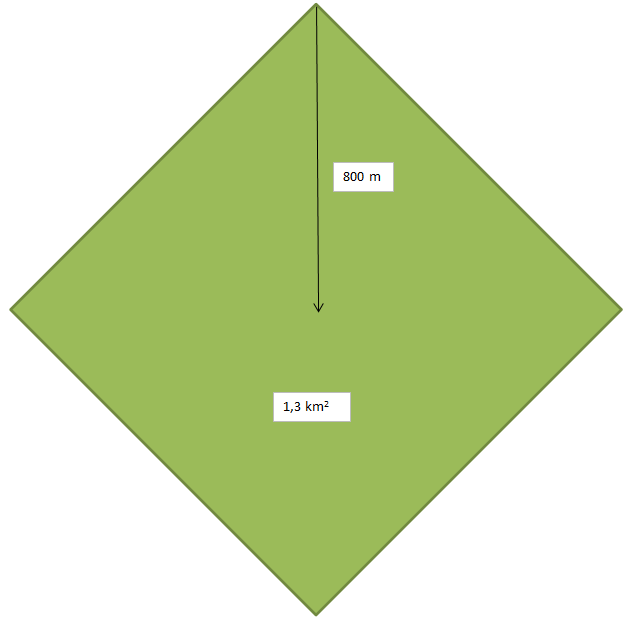
Area where walking is faster than buses or subways
That area is 1,3 square kilometer. Supposing a residential density of 6 000 people per square kilometer, the lower end of what I considered a "well-designed city", that's about 8 400 people living in that area, and up to 26 000 people using the higher end of the residential density I described. If you have proximity stores or neighborhood stores like groceries, in a well-designed city made to reduce distances, you'd get a pattern of nodes of neighborhood stores looking a bit like this:
Kooriyama in Japan, with the red dots being the results of a search for "supermarket" (BTW, 45% of trips made on foot or on a bike, only 5% on transit)
If I were to draw the "catchment area" of each store, they would look like diamonds or hexes of semi-regular dimensions, so that everyone lived within about 1 kilometer maximum from the nearest grocery, which is barely out of the zone where walking is faster than buses. So the vast majority of people in Kooriyama can get to the closest grocery faster on foot (or on a bike) than they could on a bus, even supposing there was a bus line taking them straight to the grocery.

My home suburb of Boucherville has 5 groceries for a population of 40 000 people, that's 8 000 people per grocery, so that means that the walkshed I illustrated above would have enough population to sustain one grocery store even at the lowest acceptable density of 6 000 people per square kilometer. Restaurants and convenience stores and other neighborhood stores could also be present as they require even less potential customers to subsist. The result is that most daily needs could be satisfied with trips of a distance of less than the 800 meters under which walking is faster than buses. Using transit would only be required for longer trips like for commutes or to go to malls with specialty stores (electronics, large clothing stores, etc...).

That's not even mentioning cars here.

So overall, it seems like buses are not really destined to be a major mode of transport in a well-designed city. For most neighborhood trips and trips to local stores and restaurants, walking would likely be faster than taking a bus, no matter how frequent they are. We can see this with the mode share of Japanese cities, or even with the mode share for internal trips in the Plateau-Mont-Royal neighborhood I spoke of in my article about streetcar suburbs:
Plateau-Mont-Royal internal trips' mode share
If you create an entire bike path network like what is seen in the Netherlands (or in Japan considering they shamelessly use their wide sidewalks on arterials as multi-purpose paths), local buses will never be widely used. That's the case in cities in the Netherlands that lack tram services and other forms of rapid transit like Eindhoven, which has a 40% mode share for bikes, but only 5% for public transit (source). However, rapid transit can still be dominant for long distance trips in such a case, especially for commuting.

That's not to say that buses are irrelevant for urbanism. They still fulfill a niche role of providing mobility to those who have trouble walking or during climatic conditions where people do not want to walk, much less bike, long distances. However, as I said in my earlier comparison between Sapporo and Montréal, a very high mode share for local buses is probably not a good sign in terms of urban planning and sustainable urbanism and likely a symptom of poor zoning and of an automobile-centered urban design that forces people to use motorized vehicles to get around even for short local trips. Buses can also suffice for small cities that are relatively compact so that they do not justify investing in rapid transit, but even then, investment in biking facilities could probably yield better results.