As I have said, I am a traffic engineer, my primary job is analyzing and programming traffic lights, or seeing if they are justified. So I've come to learn that in general, the level of service is God. What is the level of service?
Well, it is a letter (A to F) that is obtained through the average delay per vehicle computed either through equation or obtained through simulations. These can be calculated for every hour of the day, but for evident reasons, they are generally only calculated for two hours, the worst hour of the AM peak and the worst hour of the PM peak, where traffic is highest. Sometimes, off-peak traffic is also analyzed.
Well, it is a letter (A to F) that is obtained through the average delay per vehicle computed either through equation or obtained through simulations. These can be calculated for every hour of the day, but for evident reasons, they are generally only calculated for two hours, the worst hour of the AM peak and the worst hour of the PM peak, where traffic is highest. Sometimes, off-peak traffic is also analyzed.
How it works is that you suppose a car driving at the desired driver's speed (often 10 km/h over the limit) and calculate how long it would take to clear a certain section of road if they didn't have to slow down or stop. Then, you add the intersection and the control mode (stop signs, roundabout, traffic lights), calculate how long it takes the vehicle to actually make it through that section of street, the difference between the desired travel time and the actual travel time is the delay. This is measured in seconds per vehicle. So if you have 500 meters and a driver wants to drive at 60 km/h over that section, he could do it in 30 seconds, but if in the simulation it takes him 50 seconds to do so, then the delay is 50 seconds minus 30 seconds, so 20 seconds.
Largely in order to avoid discussions over a half second difference or the like, delay is converted into "level of service". The level of service is considered worse for a given delay on unsignalized intersections (stops signs or roundabouts), representing greater user frustration when facing long delays at these intersections.

Note that level of service for say highway interchanges and straight roads without intersection also uses A to F but is calculated differently, generally with the density of vehicles rather than the delay.
The objective of a traffic engineer in most studies is to keep level of service as low as possible to avoid delays for drivers, helping them drive faster and have to wait less for other traffic.
Now then, some of you may ask "well, what about pedestrians and cyclists? How is level of service measured for them?"
Well, the answer to that is that the default method says: Fuck 'em.
OK, that's hyperbole... It's not like the norms say to ignore them, no, they recommend accommodations to help them cross the intersection but there is no metric for level of service for pedestrians or cyclists. The dominant mentality is quite clearly "Pedestrians and cyclists should be happy to even be ABLE to cross the street, their time is not valuable at all... else they wouldn't be walking/biking".
Now, cyclists according to the norms should act like vehicles, so in a way, they could be expected to have the same level of service as cars as they should follow the same signals. But that's not the case for pedestrians. So follow me, if you want, through a thought experiment:
What if we measured a Level of service for pedestrians?
So let's suppose that we calculate a level of service for pedestrians based on the same basis as for vehicles. Pedestrians can stop and accelerate to regular walking speed almost instantaneously and so we don't have to calculate delay caused by lower than desired speeds during acceleration and deceleration. So delay is limited essentially only to the wait time before they can go ahead and cross (supposing car drivers respect pedestrian priority). Let's look at some particular cases.
Crosswalk
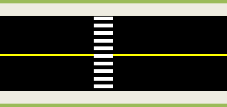
A crosswalk theoretically gives priority to a pedestrian as vehicles are supposed to stop when a pedestrian wants to cross. In reality... that rule is not always ignored, but its respect depends a lot on how the crosswalk is designed and if the police cracks down on delinquents. The narrower the crosswalk is, the more respected it is, if you have neckdowns, it will be more respected, if there are signs placed in the middle of the road to indicate the crosswalk AND the fine for disrespecting it, it will be more respected. But wide crosswalks on streets with 4 lanes without special signalization are not much respected, and sometimes even dangerous, because even if one car stops, the other coming in the other lane may not.
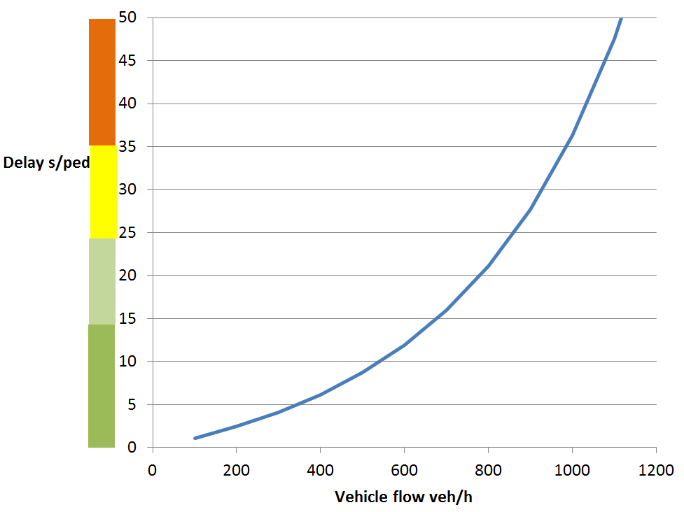
Anyway, if we suppose that a pedestrian needs 6 seconds without a car passing on the street to be able to start crossing and assert his presence, then a statistical calculus allowed me to calculate an approximate delay and LOS depending on vehicle flow (supposing this vehicle flow as the sum of flows in either direction, possibly reduced if there are 2 or more lanes per direction):

So crosswalks work best when traffic is below 900 vehicles per hour (again, sum of both directions) at peak hour. Note also that if the crosswalk is badly located and requires detours, for instance on high-throughput roads, if there's a crosswalk every 500 meters only (about a third of a mile), this may inflict an average detour of 2 or 3 minutes per pedestrian... as a level of service of F is 50 seconds and more for unsignalized intersections, that's an automatic F. Any detour of more than 80 meters is an automatic F (that's about 270 feet).
So crosswalks work best when traffic is low and when there are no detours... in short, when jaywalking on narrow, traffic-calmed streets, rather than actual crosswalks. To help crosswalks perform better, medians are a great idea as they allow pedestrians to treat a street crossing as crossing two one-direction streets in a row, for instance, if you had a street with 600 veh/h in one direction and 400 veh/h in the other, if a pedestrian has to cross it in one time, the delay could be around 35 seconds until he got an occasion to do so. But with a median, the average wait time will only be 15 seconds or so as he can cross each direction one at a time.
 |
| A median allows a crossing to be made in two legs, reducing waiting times and making it safer, with a median, even arterials with high traffic flows and 2 or 3 lanes per direction can easily be crossed by pedestrians |
 |
| A pedestrian refuge can achieve the same goal when you don't have the space for a median all along a street |
Roundabouts

Roundabouts are actually covered by crosswalks as pedestrians have to cross each branch one by one. This is not as bad as it sounds as these crosswalks tend to be split in two one-direction crossings rather than one longer crossing, and cars go at low speed in roundabouts and in their vicinity. Still, there is an additional problem with it being hard to know if cars in the roundabout are going to exit or not as most people don't signal their exit from a roundabout.
A bigger problem is the detour for pedestrians who just want to continue on ahead.

So, like crosswalks, roundabout performance is linked to traffic flow. The higher the traffic, the worse for the pedestrian. Also, detours for straight movements make roundabouts in most locations not that good for pedestrians, unless traffic is very low. Expect a level of service between C and E.
Stop signs

Stop signs are, of all the ways of controlling traffic, probably the single best for pedestrians. Like vehicles, they have to wait their turn, but unlike vehicles, pedestrians do not go only one at a time, if a group of 10 pedestrians arrive at the same time at a crossing at an intersection controlled by stops, they will not go one by one, but will all cross at the same time. The most they are likely to wait is 10 seconds, waiting for 2 or 3 vehicles to do their movement before doing theirs. That is a guaranteed level of service of A. The only detour worth mentioning is the diagonal one for pedestrians who have to cross two streets instead of going diagonally.
However, there is a caveat. At intersections of streets with two or more lanes per branch, especially ones where streets do not meet at a right angle, safety suffers as drivers may be overwhelmed by the number of lanes and sidewalks to check all approaches and corners before moving.
Traffic lights
OK, now for the big one. How are traffic lights for pedestrians? Largely, except for a few cases with narrow streets, pretty terrible.
The reason is that wide intersections take a lot of time to cross, resulting in long phases and thus long waits to get their signal telling me to cross. If you look at car signals, you have the usual three lights, a green light to tell cars to go through, a yellow light telling cars to finish their maneuvers if they can't stop safely and a red light to tell cars to not enter the intersection anymore. But since cars are so fast, the yellow light and all-red light are very short. So a 30-second traffic light for cars look like this:
25 seconds of a green light
4 seconds of a yellow light
1 second of all-red light until the next phase starts
Meanwhile, given that intersections with traffic lights are often built very wide to add turning lanes and increase vehicular capacity, and to allow trucks to turn. The result is that crossings at intersections are much longer than the width of the street further out.
For example, here is an intersection in Boucherville, my home suburb:

Note that the street is just 16-meter wide (around 50 feet) far from the intersection, but the crossing of that street at the intersection is 25-meter wide (around 80 feet). While it would take 10 to 12 seconds to cross the street by jaywalking farther away, it would take 20 seconds or more at the signalized crossing at the intersection.
What this means is that often, a 30-second pedestrian phase would be split in two:
A 5-second WALK phase during which pedestrians can start crossing

A 25-second DON'T WALK phase during which pedestrians that are in the crossing can finish crossing, but those at the sidewalk are told to stay there and wait for the next light cycle.
 |
| This symbol, but flashing |
The DON'T WALK phase is calculated by dividing the width of the crossing by the average walking speed (for a slower-than-average walker, around 1,1 to 1,2 meter per second, or around 4 feet per second, but sometimes, near hospitals and elders' homes, it can go as low as 0,8 m/s, or less than 3 ft/s). The WALK phase according to the norms is 5 seconds, more if there are a lot of pedestrians. But when we can, we give more time to it (for instance, if concurrent with a green light that lasts a minimum of 40 seconds and the DON'T WALK lasts 20 seconds, we'll often give 20 seconds to the WALK phase).
So let's take a typical traffic light phasing, with protected exclusive left-turns for the main road, and coordination to lower vehicle delays by synchronizing traffic lights (very frequent on arterials).

So while vehicles have the right to enter the intersection 86% of the time, pedestrians have the right to do so only 23% of the time, and that's an optimist case where the engineer increase WALK time during the THROUGH phase for the main road, if he didn't, then pedestrians would have the right to enter the intersection less than 10% of the time.
In this case, we can easily estimate delays. For pedestrians crossing the secondary road, they have (20/110) 18% chance of not waiting at all, and 82% chance of having an average of 45 second delay, so a delay of 37 seconds. That's a level of service of D.
For those wishing to cross the main road, they have only 5 seconds of WALK on a cycle of 110 seconds, so they have less than 5% chance of waiting 0 second, and 95% chance of waiting an average of 52,5 seconds. That means an average of around 50 seconds, also D, but getting pretty close to E, which is a level of service that is often deemed unacceptable in traffic studies for vehicles.
Those who do the two crossing can expect to wait about 55 seconds, entering E level of service.
In my work, I've frequently seen traffic signals with cycles of 120 to 160 seconds on arterials. These basically guarantee E levels of service for any pedestrian crossing the main street. This delay represents the equivalent of nearly 100 meters of walking distance, losing about a minute per intersection. And while cars can have synchronized lights, pedestrians don't have this chance. So if you have 4 traffic lights in a row, cars traveling along the main road can expect to have to wait at only one or two of these intersections. Pedestrians can expect to face an average delay of 30 to 45 seconds on each light, that means 2 or 3 minutes of delay.
Even worse, sometimes you have intersections where particularities compel traffic engineers to remove pedestrians crossings on one or two branches, like for instance when you have two left-turning lanes:
 |
| This intersection allows pedestrians to cross only the northern approach (Taschereau Boulevard in Longueuil) |
This forces pedestrians to do THREE crossings. Needless to say, most pedestrians refuse to do so and will often cross without signals.
Pedestrians buttons can compound the issue, when pedestrian phases aren't in RECALL mode (always happening every cycle), pedestrians who normally would arrive during their WALK phase may not even have it because of the need to push the button (often called the "beg button" by urbanists).
The best case scenario is an intersection with very narrow branches with simple phasing (green light for main road, green light for secondary road), which even then will likely give a level of service of C to pedestrians. But if traffic flows increase, the cycle will have to be increased, increasing delay for pedestrians.
Conclusion
Crosswalks provide good levels of service to pedestrians only when traffic flows are low (but allowing jaywalking work better in these cases) or on narrow streets with special amenities. Stop signs provide excellent service to pedestrians, having next to no delay for them. Roundabouts are middling for pedestrians, forcing them to go around the roundabout and to cross many crosswalks (even if they are relatively easy to cross). Traffic lights, especially on the wide arterials we have so often built in suburbia, will impose important delays to pedestrians, especially those wishing to cross the arterial, who will frequently have a level of service of E (at least, they would if we bothered to calculate it). That's not even talking of issues of safety.
So what does that mean? That means that crosswalks with medians and stop signs should be preferred to traffic lights for areas with a focus on pedestrians. It also means that the habit of channeling all the traffic on a few wide arterials, forcing each intersection to have multiple turn lanes and many through lanes, is absolutely terrible for pedestrians. A street grid with densely packed streets would do a better job of responding to all users, as it would dilute traffic on many streets, all these streets could be narrow, with 3 or 4 lanes only (1 per direction plus a shared left-turn lane or 2 per direction). Ideally, I believe there should not be any width of pavement greater than 12 meters (40 feet) in a city, any pavement wider than that should be broken in two with a median wide enough to use as a pedestrian refuge.
To return to my original question: what if we accounted pedestrian delay and level of service? Well, it would have little impact on intersection performance, which averages the delays of all vehicles on all approaches. We have been so great at repressing pedestrian movements through a focus on motorized transport it is rare to see more than 100 pedestrians a day on most arterial intersections outside a few dense cities. Not surprising when these arterials serve as walls in developed areas, barriers to pedestrian and cyclist trips.
Note that there is also the possibility of shared spaces, as interesting and effective as it may be, resistance to them is high in North America and most arterials are not fit for them (shared spaces work with low speed and low traffic flow, without trailer trucks... most arterials in North America have high speed, a lot of traffic and plenty of trailer trucks).