Sunday, January 25, 2015

Highways and boulevard: a capacity-cost analysis

I recently compared urban freeways to subways to demonstrate how they are not a cost-effective way to quickly transport great amounts of people in urban areas. However, that comparison involved very expensive and high-capacity infrastructure, that not that many cities need or can fully utilize. Many cities are also much less dense, so they may find it easier to build surface highways that can be much cheaper than the trench highway I used in an example.

So, let's see if highways make sense as a main transport infrastructure for urban developments. I will do so by comparing surface highways with urban boulevards, their cost and their capacity. But first, I must address something

Why the focus on capacity?

Some people who read this may find my choice to focus on capacity rather than, say, speed to be annoying, or even in bad faith. The choice of capacity as a metric of performance, despite capacity not being that relevant to the end user (its relevance largely limited to its effect on speed when congestion occurs), is justified by the fact that transport capacity ultimately impacts and limits development. One of the main reasons to oppose new developments by politicians is the fear of congestion, that transport infrastructures will be overwhelmed by the new developments and make current transport patterns much harder, if not impossible, to maintain. This leads to traffic impact assessments and traffic studies (which I plan to criticize in another article one day).

So lacking transport capacity caps developments, if transport links have reserve capacity, it is easier to develop areas and to increase the number of residents and jobs in an area. As such, for cities, it would be wise to seek ways to cheaply build transport infrastructure that have high capacity, to reduce the cost of infrastructure to sustain a given population.

OK, let's get started

Now, when I talk of "highway", I refer to grade-separated motorways that have no intersection, just interchanges, so as to maintain a constant speed without requiring vehicles to stop on their trips. These roads bear different names in different places in the world: motorways, expressways, freeways, highways, etc... So let me be clear, THIS is what I'm talking about:

This is an highway: wide roads without intersections, with accesses limited to ramps.
On the other hand, when I speak of boulevard, I mean roads that are straight and built for higher capacity but which have many intersections, often controlled by traffic lights. They have sidewalks, often with buildings built on them and occasionally have bike infrastructure on them.
This is a boulevard

So is this
And this
Boulevards can have different typologies, there are urban boulevards which have a relatively narrow pavement width with large sidewalks and buildings built right next to them, and there are some boulevards that are what Charles Marohn at Strongtowns calls "stroads", built with highway-like standards... but still with frequent intersections and traffic lights rather than interchanges. All are boulevards, even if the areas they serve differ. Though my comparison will mostly consider well-designed urban boulevards rather than awful stroads, the same conclusions apply.

Cost

So, the first issue is, what do they cost? There is no easy answer for highways. Highways in flatlands in rural areas can be relatively affordable, I've seen some built for about 20 millions per kilometer (30 millions per mile), sometimes a bit less. However, surface highways built in urban areas are more expensive than that, for example, the A-19 in the suburbs of Montréal is expected to cost about 600 million dollars for 9 kilometers, so a bit over 60 millions per km (around 100 million dollars per mile). This is generally due to the cost of land acquisitions and the cost of more frequent interchanges and highway bridges that need to be built.

Elevated highways are even more expensive, maybe around 200 millions per km (320 millions per mile) and underground subways are monstrously expensive, with prices frequently approaching or going over one billion per mile (see Big Dig). Again, interchanges are massively responsible for these costs, a single interchange can cost 50-60 million dollars.

As to boulevards, their costs vary much less, mainly with the number of lanes and how much money may be spent on beautification. Recently, a roughly 3-km length of boulevard was approved in Montréal, the boulevard itself is budgeted to cost 15 million dollars, so 5 million per km (8 million per mile)... and the interchange that will connect it to an highway will cost 60 million dollars.

So, overall, I will assume a cost of 50 millions per km (80 millions per mile) for an urban 4-lane (2 per direction) highway built on the surface in a low-density urbanized setting, and a cost of 5 millions per km for a 4-lane boulevard.

Capacity

The capacity of an highway lane is around 1 600 to 1 800 vehicles per hour. Some highways see as high as 2 000, but they are the exception. In general, congestion will occur at interchanges.

Meanwhile, the capacity of a lane on a boulevard is much lower, around 800 to 1000 vehicles per hour. The reason for that is simple: since they have intersections and some of these intersections will be with other highly-used boulevards, cars on the boulevard may only have the right to cross the intersection half the time. Intersections serve as bottlenecks. A boulevard without intersection would have the same capacity as an highway... and would essentially BE an highway.

Supposing a standard occupancy of 1,3 person per vehicle, that leaves a capacity in persons per per hour per direction of:

4 600 pphd for a 4-lane highway
2 600 pphd for a 4-lane boulevard

So an highway has around twice the capacity of a boulevard... HOWEVER, it also costs 10 times as much per km. The result is that more boulevards can be built for the same price. So you're not comparing one highway versus one boulevard, but an highway versus a GRID of boulevards.
2 highways intersecting in a city, or...
...a grid of boulevards, each separated by 500 to 1 000 meters (1 600 to 3 200 feet)
Vehicle capacity on boulevards is thus 5 times cheaper than on highways. 

BUT WAIT, there's more...

I've been only considering capacity for cars here, but there are other modes of transport. Transit, bicycles, walking, these are ways of getting around too.

For example, if we have a bus line with 20 regular buses per hour, with each bus carrying as many as 60 people. That means a capacity of 1 200 pphd in transit. Use articulated buses instead and it's up to 2 400 pphd. Even better, have a local line and an express line on the same boulevard with different stops, and you can have two lines superposed on one another, doubling capacity. Transit will occupy some space on the boulevard and reduce somewhat vehicle capacity, but this impact is very low due to the spatial efficiency of transit.

Providing a simple 3-meter bike path (10-foot) can also get you about 1 000 pphd on bikes, widen that path a bit and you can double that to 2 000 pphd.

And sidewalks have very high capacity, with decently sized sidewalks on both sides, you could maybe get as high as 4 000 pphd on foot.

However, that's only valid for the boulevard. Cyclists and pedestrians are outright banned from highways, even if they did want to travel there (and they wouldn't). Highways create a big wasteland around them to achieve object clearance zones (or recovery zones), and their high speed favors distant, sprawled out developments that means that even if you decide to build footpaths or bike paths alongside them, no one would use them.

As to transit, though buses can certainly travel on highways, they cannot SERVE them. Vehicles are not supposed to stop on highways unless they have a malfunction. And even if they could, highways are off-limits to pedestrians. AND even if they weren't, highways rarely have walkable developments at interchanges, so the use of such buses would be limited, if not completely inexistent. So only express buses traveling long distances can really use highways.
Example from Houston, buses use parallel roads instead of the freeway to go downtown
Still, you can use highways for express buses, shouldn't that count? Well, no. Because you can do the same with boulevards too.

So what does this mean? This means that the capacity of highways for transit is 0, for bikes is 0, for walking is 0. But boulevards, as they are space efficient and closer to developments, can easily support all these modes of travel.

So in the end, a proper comparison leads to this graph, comparing a 4-lane boulevard with a standard high-frequency bus line and bike path, a 4-lane boulevard with a high-frequency articulated bus line and bike path, a 4-lane boulevard with a tram using 2 of these lanes (thrown in just for fun) and a 4-lane highway:
Comparison of capacity between different boulevards and an highway

Or, if some protest about including bikes and pedestrians, fine, just motorized modes:
Comparison of capacity between different boulevards and an highway, motorized modes only

Note that I'm even low-balling transit here. You can get up to 10 000 pphd with transit on a transit-only lane if you use big vehicles and very high frequencies. And with wide enough bike paths, you can double that bike capacity.. and maybe even triple it.

So even a simple 4-lane boulevard with a bus line using regular buses can nearly match highway capacity, without including bikes in the total.

So that means that boulevards can support much more development than highways, especially urban-style development that allows trips to be made on foot or on a bike, and all for a fraction of the costs of highways.

What about speed?

OK, now let's talk of speed a little. Yes, highways allow much higher speed. A car traveling on a boulevard will travel at a speed on average between 25 and 35 km/h (16 to 22 mph), compared to an highway's speed of 100 km/h or more. Transit is even slower, at an average of 15 km/h (around 9-10 mph) for local buses, trams and BRTs can increase that to 20-25 km/h. Bikes go maybe on average at 15-20 km/h.

However, it's important to point out that since highways are so expensive and take so much space, people rarely live right next to them. Even cities with plenty of highways like Houston spaces them by 5 or 6 km between them (3,5 miles), whereas grids of boulevards can have boulevards every 500 or 1 000 meters apart. So getting on an highway may take an average of 5 minutes, likewise, getting from the exit to the destination may also take another 5 minutes. Getting to a boulevard is a much simpler affair, maybe needing only 1 minute of driving, with destinations often right on the boulevard.

As a result, the average speed of highways for urban trips isn't that much higher than on boulevards:
Average speed of trips using boulevards or highways, depending on distance, once we take into account the time to access the road
The average commuting distance in the United States is around 8 miles, or 13 km. On such a trip, an uncongested highway saves people only 10 minutes versus an uncongested boulevard. But as I demonstrated, highways are more likely to congest due to their high cost and low capacity, so it doesn't take much congestion to make that advantage nearly vanish.

So boulevards do not support the unending sprawl that highways do as they are not as fast, but they're not that slow either. The average commute is 25 minutes in Canada and the US, supposing an average of 30 km/h for boulevards, that means 12,5 km. If you use that distance as the maximum tolerable distance from the downtown area, that represents nearly 500 square kilometers of areas close enough to downtown to tolerate urban development. With a pretty average density of 1 500 people per square kilometer, which is Riverside's overall density (not exactly the world's densest city), that means 750 000 people can live in that area. With the density of Los Angeles, so around 3 200 people per square kilometer (again, not exactly the densest city in the world), that would be enough for a city of 1,6 million people. With the density of Montréal, so 4 700 people per square kilometer, that would be enough for 2,35 million people. With European- or Asian-style density, you could house a city of 3 or 4 millions in that area.

Conclusion

I think it's pretty clear that highways are the wrong tool to deal with urban transport issues. They are too expensive and their speed is not actually required for most urban trips. They may still be justified to respond for the need for speedy long-distance trips however. Again, it justifies my point of view of not building highways in urban areas, or only a few 2-lane highways with high tolls to discourage urban trips from using them needlessly, in order to preserve their speed for long-distance trips and freight which actually need the speed.

Thursday, January 22, 2015

Affordable housing and subsidized housing: Should governments intervene directly in housing?

I've taken many positions in favor of deregulation of urban developments on this blog, notably against municipal zoning that restricts the building of new housing in established areas. So, if government intervention through zoning is generally not all that great, is there a way for government to intervene that can actually be helpful?

Subsidized housing

Subsidies are a regular government tool to help certain vulnerable groups of society or create incentives to reward behavior and actions believed to be beneficial for society as a whole. And so it is normal that subsidized housing is often one of the first measures that come to mind when dealing with the issue of people who cannot find affordable housing. This can either take the form of purpose-built housing (the Projects) or specific units in privately-owned buildings that are targeted for subsidies.
Habitations Jeanne-Manche in Montréal, a public housing project
Whether the government builds housing on its own or it subsidies private units, the dynamic is the same: some housing units are rented below market price AND the building cost. To some extent, it can work for a few vulnerable groups, but in the end, it is not a good idea.

The main problem is a question of fairness. Housing costs are often the single greatest spending category of the regular household, so subsidizing it is extremely expensive. This fact means that the number of subsidized units available to rent will generally be much smaller than the number of people who are recognized as in need of them.This means that not everyone can get them, worse, as these require subsidies, this means that the funding for this housing will need to come from taxes.

Unless the taxes for this are specifically targeted only so the richest individuals have to pay, this will mean that people who need access to that subsidized housing but haven't been able to get access to it because of a shortage of spaces, or people who are just above the criteria required to have the right to apply, end up on the private market for housing, likely getting a worse apartment for a higher price AND have to pay taxes to allow those who had access to the housing to pay less for higher-quality apartments.

So, it's great for recipients, but not for anyone else. That's the issue of fairness of the subsidized housing solution... it may be justifiable for a few vulnerable groups, but as a solution for affordable housing, it is seriously lacking. It doesn't make the situation of housing affordability better for society, it arguably makes it worse, just with a few people being able to escape it.

Rent control

This is especially controversial as it is extremely common in big cities. Québec has a form of it, as do many other Canadian provinces, New York has it, San Francisco has it, etc... The idea is that rents will be kept from rising too fast and capped to a certain rate of growth. This protects current renters from rapidly accelerating rents that would force them to look elsewhere for cheaper, smaller or worse located apartments.

One of the criticism of this kind of intervention that is commonly heard is that this reduces the profits from building rental units and so discourages building new housing. Personally, I think that argument is overblown, for a simple reason: no regulation I know of determines rent for new units. New units' rents are therefore fixed by the market, and when the rent-controlled units are in shortage, people may have to go for the new units' higher rents, or the new units may be condos instead of rental units. There may be a small disincentive in that after construction, rents will not be able to increase quickly, but anyway, housing built to be unprofitable at current rental rates, only becoming profitable if rents increase much faster than inflation can be called speculative and ill-advised. So it's not necessarily a bad thing.

The main opposition to rent control is the same as that of subsidized housing: you create two categories of people, people who have the chance of living in older rent-controlled housing, and people who don't. Though there is no direct wealth transfer from the latter to the former, that is still an unfair situation, and one that doesn't help all people or help make affordable housing available to all.

Some people say that rent control is responsible for the high rents in San Francisco and New York, I'm more inclined to blame zoning. I doubt rent control has such a big impact. Montréal has it and remains pretty affordable. But rent control may indeed discourage new rental developments and encourage condos instead, and it discourages investment in old housing, which is more likely to filter as a result... unless it's bought outright, destroyed and replaced.

Still, rent control is not a solution to unaffordable housing prices. It favors incumbent residents and does nothing to help newcomers. It is a "solution" to protect some from the impact of a housing market in shortage... which is perhaps its greatest flaw as it allows people who live in the area to be unaware of the problem of increasing unaffordability. Thus, inertia in public policy can continue.

Of course, when there is no major affordability problem, rent control is absolutely useless. Rents in an healthy housing market should not be increasing constantly, and may even fall in real terms (filtering).

So, what then?

So if using subsidies in a major way and trying to control costs through regulations are not good ideas and do not solve issues of housing affordability, what can government do that can actually help, if anything?

One thing I said in an earlier post, using an example with the car industry, is that if the amount of products one can build is limited, then the market tends to concentrate on the most profitable product they can build. In most cases, that is luxury housing. When the top end of the market gets saturated, developers will go down market. That is because private developers want to maximize profits.

Where the government could act is that it could set up a public corporation to act as a housing developer. Instead of maximizing profits, this public corporation could instead be given specific goals that society sees as good in themselves: provide a certain number of units, favor affordable units for lower-middle-class and poorer people, etc...  In a way, that corporation could act as an altruistic developer, but with a rule that says that it must not be unprofitable. If an unit costs 150 000$ to build, then it must sell it for at least 150 000$.

In other words, if private developers tend to aim for the top end of the market to maximize profits, this public corporation should rather aim for the bottom end of the market while having to avoid financial losses. Avoiding losses means avoiding having to be subsidized by the government, which is a big problem as I mentioned earlier in terms of fairness, as only a minority get to access below-cost apartments of higher quality than similarly priced units on the market as the rest of the population, including people of similar social status who haven't had the chance of getting a subsidized unit, are taxed to make it possible.

This is not without a precedent. Again, let me use Japan as an example, after WWII, much of Japan's housing had been devastated. Even when they were starting to rebuild, they faced a major problem of housing shortage, so in 1955, they set up the "Japan Housing Corporation" which had the mission of building plenty of housing at affordable costs and as quickly as possible. This led to the adoption of the "danchi" as a model for housing (inspired by Soviet housing apparently):
A computer model of a danchi, balconies in front

...stairs in the back, each pair of units on a floor having stairs of their own.

Example of danchi in Sapporo

...and in Yokohama
Even today, the corporation still exists but is now renamed "Urban Renaissance". It is still building around 10 000 units per year and owns more than 900 000 units in all of Japan. Older buildings have been torn down or sold to developers.

What they did was often select cheap lands within close range of train stations or with good bus service, then build these 3- to 5-story buildings, typically without elevators. The units themselves were small, as they needed to be affordable to occupants. So you still have these groups of Danchis all over Japan. However, they tend to be in relatively breezy areas as they didn't build them really close to one another, some form of "tower in the park" ideal.

An extreme example of this model is Singapore's Housing and Development Board, which now owns 82% of all housing in Singapore and has started building middle-class and even luxury housing. Though it's not exactly the same as it tolerates a yearly deficit covered by the government.

Conclusion

If government is to intervene in housing, it must do so understanding the dynamics of the housing market. Subsidies ultimately only help a minority of the population and are not a solution. But an approach wherein the government sets up a public housing corporation tasked at solving certain socio-economic issues and addressing the lack of affordable housing can be a valid intervention, as long as that corporation is asked to achieve at least a balanced budget. The housing it may build may be too simple or too small for middle-class or richer individuals, but may satisfy a need for affordable housing.

Wednesday, January 7, 2015

World's worst investment: why urban highways destroy wealth

Infrastructure investment is often seen as a good way to stimulate the economy and to provide facilities to allow the economy to grow. It's a pretty uncontroversial responsibility of government to provide for such infrastructure. However, even as a left-winger, I know that we have to be careful with government investment and make sure the money spent is spent effectively. Since government has a huge ability to spend and subsidize, it can effectively maintain unprofitable, wasteful ventures almost forever, taxing the rest of society to subsidize them, creating a drag on the economy. In the private sector, this is much less likely as actors do not have the financial capacity of government and so trying to support an unprofitable venture will inevitably bankrupt them, forcing the venture to halt.

Now, sometimes unprofitable ventures still have social benefits or moral imperatives that justify them. So I'm not condemning every government spending program here. But clear-minded reflection and analysis is necessary to make sure money is well-spent.

Which brings me to the matter of urban highways, which is the single most glaring example of an infrastructure spending that is ill-advised, wasteful and yields no positive outcome for society. They are largely the single most wasteful infrastructure spending project that we nonetheless keep doing over and over.

An example: highway vs subway, case of Montréal

The 1960s in Montréal were a time of big public projects, like in most of North America. In 1967, Montréal was slated to receive the International Exposition, and in order to welcome the world, projects that had been on ice for years finally got funding from governments now afraid to look like incompetent buffoons in front of an international audience. Consequently, two major transport projects were launched and done in the same lapse of time. The first was the Décarie Highway, a trench highway built along a previous boulevard, minimizing expropriations, and the second was the first 25 km of the Montréal Metro. 

This provides a good comparison of the costs and capacities of highways versus rail-based transit (though Montréal's metro is on tyres), as in both cases, the projects would be built underground, one in a trench, the other in tunnels. Too often, people claim that highways are cheaper than transit, or at least act like they are, but they do so comparing highways built on the surface in suburbs or fields with underground subways, which is an apple-to-oranges comparison.

Without further ado, let me present the Décarie Highway:

Décarie highway, 3 lanes per direction in a trench located in a densely inhabited section of Montréal

Décarie highway on a map of Montréal, connecting the A-40 to the north to A-20 to the south
Now, some numbers:
  • The highway is 6,4 km long
  • With 3 lanes per direction, it offers a passenger capacity of roughly 7 000 to 8 000 people per hour per direction
  • Its cost was 370 million 1967 Canadian dollars, or about 60 million dollars per km
  • In 2014 dollars, the cost would be 2,6 billion dollars, or 405 million dollars per km
  • If the highway had to be funded entirely through tolls, the toll would likely have had to have been around 35 cents per km, or around 60 cents per mile (in 2014 dollars).
 At the same time, the initial Metro network was built, opening also for the 1967 Expo:
The original three lines of the Montréal Metro, opened for the '67 Expo, versus the current system
The system was built entirely underground. Even if we wanted to take it on the surface, we likely couldn't due to the rubber tyres and the harsh winter (Sapporo does it but by covering the surface lines entirely).

Some numbers for the Metro:
  • The original network was 25 km long, including a tunnel under the St. Lawrence River.
  • Each train has up to 9 16-meter-long wagons (54 feet) with a capacity of 100 people per wagon, 150 in crush conditions, and a frequency of up to one train per 3 minutes. That is a capacity between 18 000 and 29 000 people per hour per direction.
  • This original network cost 214 million dollars in 1967 Canadian currency, or 8,5 million dollars per km
  • In 2014 terms, that is 1,5 billion dollars, or about 60 million dollars per km
Just for fun, let's mention the Expo Express, to my knowledge the first fully-automatic Heavy Rail Transit line in North America that ran on a line 5,7-km-long, built for 18 million dollars (125 millions in 2014 dollars), with a capacity of around 20 000 people per hour per direction. Unfortunately, after the Expo, the line went from nowhere to nowhere, and so the service was discontinued in 1972.

So, to sum up...

  • The highway was 7 times more expensive per km than the subway to build
  • The highway passenger capacity was 3 to 4 times less than the subway
  • So overall, the highway is 20 to 30 times more expensive to build per capacity-km
So what does that say about what is the better investment? Sure, some people can point out the highway is also used for freight, but with the passenger capacity of subways, this allows freight an easier time to navigate surface streets.

The reasons for the higher costs of highways are simple: they take more space, thus when land is expensive, they will be more expensive to build, likewise when you need to build elevated structures or to dig in the ground. Otherwise, laying tracks or building highway-grade pavement is roughly the same price. Subways also include the cost of wagons, of electrification and of maintenance centers too, which makes highways even more expensive because these costs have to be paid by its users and not accounted for when you build them.

OK, it was more expensive, but is it worth it? Did it create wealth?

Something being more expensive doesn't necessarily make it a bad investment. A pickup truck is more expensive than a compact car, but to some people, it may be a better investment if they need to haul a lot of stuff for their work. So, do urban highways help create exponentially more wealth than transit?

First of all, please note that I speak of URBAN highways, highways built in inhabited areas and that cut across them in order to facilitate commuting and movements inside the urbanized area, and not highways between cities that allow movements BETWEEN cities to be done faster. These are two completely different beasts.

Anyway, urban highways have a terrible legacy regarding wealth in the cities they have been built in. In almost every case, the areas adjacent to highways have become blighted by their presence. Highways achieve this because:
  • They cut off parts of the city from the rest of it, making it harder to get on the other side for residents, which makes living in the area less desirable.
  • They create a lot of nuisance through increased traffic and visual and aerial pollution, making the areas even less desirable.
  • They suck out traffic from existing healthy commercial arterials, which eliminates pass-by trips to the businesses on these arterials, weakening them and even leading to their closure.
  • As people require cars to use the highway, any business or service that is not in a car-oriented area will not benefit from them, so older urban areas with few parking spots cannot cater to highway users. Buildings have to be destroyed to make way for parking lots in order to attract highway users, but doing so eliminates a lot of business and services, reducing the area's vitality and the amount of wealth in them.
  • Since the highway is so fast, proximity matters less, and as greenfield developments are always cheaper than urban infill development or redevelopment, it makes housing and businesses in sprawl cheaper and more convenient in comparison to urban development, so development money flees to undeveloped areas, leading to under-investment in existing areas and their decline.
Elevated and underground highways can reduce the impact, but they are extremely expensive to build, as the Décarie Highway clearly demonstrates. 

An elevated highway in Nagoya, tall and narrow to minimize impacts on the area... but with a toll around 1$ per mile traveled
Urban highways do not create wealth, they rather destroy the wealth of the areas they're built in. However, for short-sighted suburban mayors and officials, they bring development to their suburbs as they favor greenfield development. Yet, this "development" needs to be called what it actually is, "displacement". Every new mall in the suburbs tends to be balanced by dying malls or commercial areas in the city.

On a macro level, there is no link between the amount of highway lanes per capita and the wealth of metro areas. San Francisco is very rich yet has next to no urban highways. Vancouver famously has no highway within the limits of the core city and is doing extremely well.

The richest metropolitan areas in the US are San José, San Francisco, Seattle, Boston, Washington, Houston, New York, Portland, Hartford and Salt Lake City. Areas with relatively few urban highways are overrepresented in that list, with Houston being the one big exception.

Meanwhile, transit is well-known for generating plenty of development around it and revitalizing areas it is built in. This is actually hurt by zoning in much of North America, but the few places that have embraced it like Arlington in Virginia or Vancouver seem to be positively booming.

Conclusion

So overall, urban highways, which are supremely expensive compared to alternatives for urban passenger trips, do not seem particularly efficient at creating wealth for society at large, they even seem to actually hurt wealth creation. Worse, highways help create a donut effect where the old neighborhoods at the center of a metropolitan area decline and become blighted as wealth flees to the periphery.

So as far as public infrastructure investments are concerned, urban highways are certainly one of the worst ones. They are expensive and yield very little benefit for society overall. However, they do benefit a certain group of people who naturally gravitate to suburbs, at the expense of city residents. Fairness dictates then that highway users have to shoulder the cost of them rather than highway costs being collectivized regardless of use. Tolling urban highways should therefore be the preferred way ahead for cities stuck with them.

An even better way forward for highways in North America would be to give highway construction and maintenance over to public State corporations rather than highways being directly built and maintained by DOTs and ministries of Transport. The State corporation could rely on the government's line of credit to borrow funds but would be asked to self-fund itself through tolls or other revenues. That way, highways would be built only where drivers would be willing to pay for their full cost. If they do not, then highways would not be built. If alternatives exist to do the job for less, they would stand an higher chance of seeing the light of day.

Saturday, January 3, 2015

What if we calculated level of service for pedestrians?

As I have said, I am a traffic engineer, my primary job is analyzing and programming traffic lights, or seeing if they are justified. So I've come to learn that in general, the level of service is God. What is the level of service?

Well, it is a letter (A to F) that is obtained through the average delay per vehicle computed either through equation or obtained through simulations. These can be calculated for every hour of the day, but for evident reasons, they are generally only calculated for two hours, the worst hour of the AM peak and the worst hour of the PM peak, where traffic is highest. Sometimes, off-peak traffic is also analyzed.

How it works is that you suppose a car driving at the desired driver's speed (often 10 km/h over the limit) and calculate how long it would take to clear a certain section of road if they didn't have to slow down or stop. Then, you add the intersection and the control mode (stop signs, roundabout, traffic lights), calculate how long it takes the vehicle to actually make it through that section of street, the difference between the desired travel time and the actual travel time is the delay. This is measured in seconds per vehicle. So if you have 500 meters and a driver wants to drive at 60 km/h over that section, he could do it in 30 seconds, but if in the simulation it takes him 50 seconds to do so, then the delay is 50 seconds minus 30 seconds, so 20 seconds.

Largely in order to avoid discussions over a half second difference or the like, delay is converted into "level of service". The level of service is considered worse for a given delay on unsignalized intersections (stops signs or roundabouts), representing greater user frustration when facing long delays at these intersections.
Note that level of service for say highway interchanges and straight roads without intersection also uses A to F but is calculated differently, generally with the density of vehicles rather than the delay.

The objective of a traffic engineer in most studies is to keep level of service as low as possible to avoid delays for drivers, helping them drive faster and have to wait less for other traffic.

Now then, some of you may ask "well, what about pedestrians and cyclists? How is level of service measured for them?"

Well, the answer to that is that the default method says: Fuck 'em.

OK, that's hyperbole... It's not like the norms say to ignore them, no, they recommend accommodations to help them cross the intersection but there is no metric for level of service for pedestrians or cyclists. The dominant mentality is quite clearly "Pedestrians and cyclists should be happy to even be ABLE to cross the street, their time is not valuable at all... else they wouldn't be walking/biking".

Now, cyclists according to the norms should act like vehicles, so in a way, they could be expected to have the same level of service as cars as they should follow the same signals. But that's not the case for pedestrians. So follow me, if you want, through a thought experiment:


What if we measured a Level of service for pedestrians?

So let's suppose that we calculate a level of service for pedestrians based on the same basis as for vehicles. Pedestrians can stop and accelerate to regular walking speed almost instantaneously and so we don't have to calculate delay caused by lower than desired speeds during acceleration and deceleration. So delay is limited essentially only to the wait time before they can go ahead and cross (supposing car drivers respect pedestrian priority). Let's look at some particular cases.

Crosswalk

A crosswalk theoretically gives priority to a pedestrian as vehicles are supposed to stop when a pedestrian wants to cross. In reality... that rule is not always ignored, but its respect depends a lot on how the crosswalk is designed and if the police cracks down on delinquents. The narrower the crosswalk is, the more respected it is, if you have neckdowns, it will be more respected, if there are signs placed in the middle of the road to indicate the crosswalk AND the fine for disrespecting it, it will be more respected. But wide crosswalks on streets with 4 lanes without special signalization are not much respected, and sometimes even dangerous, because even if one car stops, the other coming in the other lane may not.

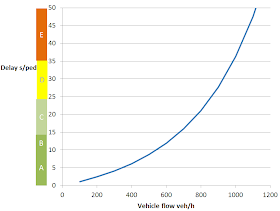
Anyway, if we suppose that a pedestrian needs 6 seconds without a car passing on the street to be able to start crossing and assert his presence, then a statistical calculus allowed me to calculate an approximate delay and LOS depending on vehicle flow (supposing this vehicle flow as the sum of flows in either direction, possibly reduced if there are 2 or more lanes per direction):

So crosswalks work best when traffic is below 900 vehicles per hour (again, sum of both directions) at peak hour. Note also that if the crosswalk is badly located and requires detours, for instance on high-throughput roads, if there's a crosswalk every 500 meters only (about a third of a mile), this may inflict an average detour of 2 or 3 minutes per pedestrian... as a level of service of F is 50 seconds and more for unsignalized intersections, that's an automatic F. Any detour of more than 80 meters is an automatic F (that's about 270 feet).

So crosswalks work best when traffic is low and when there are no detours... in short, when jaywalking on narrow, traffic-calmed streets, rather than actual crosswalks. To help crosswalks perform better, medians are a great idea as they allow pedestrians to treat a street crossing as crossing two one-direction streets in a row, for instance, if you had a street with 600 veh/h in one direction and 400 veh/h in the other, if a pedestrian has to cross it in one time, the delay could be around 35 seconds until he got an occasion to do so. But with a median, the average wait time will only be 15 seconds or so as he can cross each direction one at a time.
A median allows a crossing to be made in two legs, reducing waiting times and making it safer, with a median, even arterials with high traffic flows and 2 or 3 lanes per direction can easily be crossed by pedestrians


A pedestrian refuge can achieve the same goal when you don't have the space for a median all along a street


Roundabouts


Roundabouts  are actually covered by crosswalks as pedestrians have to cross each branch one by one. This is not as bad as it sounds as these crosswalks tend to be split in two one-direction crossings rather than one longer crossing, and cars go at low speed in roundabouts and in their vicinity. Still, there is an additional problem with it being hard to know if cars in the roundabout are going to exit or not as most people don't signal their exit from a roundabout.

A bigger problem is the detour for pedestrians who just want to continue on ahead.
So, like crosswalks, roundabout performance is linked to traffic flow. The higher the traffic, the worse for the pedestrian. Also, detours for straight movements make roundabouts in most locations not that good for pedestrians, unless traffic is very low. Expect a level of service between C and E.

Stop signs

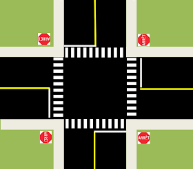
Stop signs are, of all the ways of controlling traffic, probably the single best for pedestrians. Like vehicles, they have to wait their turn, but unlike vehicles, pedestrians do not go only one at a time, if a group of 10 pedestrians arrive at the same time at a crossing at an intersection controlled by stops, they will not go one by one, but will all cross at the same time. The most they are likely to wait is 10 seconds, waiting for 2 or 3 vehicles to do their movement before doing theirs. That is a guaranteed level of service of A. The only detour worth mentioning is the diagonal one for pedestrians who have to cross two streets instead of going diagonally.

However, there is a caveat. At intersections of streets with two or more lanes per branch, especially ones where streets do not meet at a right angle, safety suffers as drivers may be overwhelmed by the number of lanes and sidewalks to check all approaches and corners before moving.

Traffic lights

OK, now for the big one. How are traffic lights for pedestrians? Largely, except for a few cases with narrow streets, pretty terrible.

The reason is that wide intersections take a lot of time to cross, resulting in long phases and thus long waits to get their signal telling me to cross. If you look at car signals, you have the usual three lights, a green light to tell cars to go through, a yellow light telling cars to finish their maneuvers if they can't stop safely and a red light to tell cars to not enter the intersection anymore. But since cars are so fast, the yellow light and all-red light are very short. So a 30-second traffic light for cars look like this:

25 seconds of a green light
4 seconds of a yellow light
1 second of all-red light until the next phase starts

Meanwhile, given that intersections with traffic lights are often built very wide to add turning lanes and increase vehicular capacity, and to allow trucks to turn. The result is that crossings at intersections are much longer than the width of the street further out.

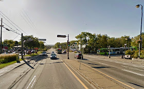
For example, here is an intersection in Boucherville, my home suburb:
Note that the street is just 16-meter wide (around 50 feet) far from the intersection, but the crossing of that street at the intersection is 25-meter wide (around 80 feet). While it would take 10 to 12 seconds to cross the street by jaywalking farther away, it would take 20 seconds or more at the signalized crossing at the intersection.

What this means is that often, a 30-second pedestrian phase would be split in two:

A 5-second WALK phase during which pedestrians can start crossing
A 25-second DON'T WALK phase during which pedestrians that are in the crossing can finish crossing, but those at the sidewalk are told to stay there and wait for the next light cycle.
This symbol, but flashing

The DON'T WALK phase is calculated by dividing the width of the crossing by the average walking speed (for a slower-than-average walker, around 1,1 to 1,2 meter per second, or around 4 feet per second, but sometimes, near hospitals and elders' homes, it can go as low as 0,8 m/s, or less than 3 ft/s). The WALK phase according to the norms is 5 seconds, more if there are a lot of pedestrians. But when we can, we give more time to it (for instance, if concurrent with a green light that lasts a minimum of 40 seconds and the DON'T WALK lasts 20 seconds, we'll often give 20 seconds to the WALK phase).

So let's take a typical traffic light phasing, with protected exclusive left-turns for the main road, and coordination to lower vehicle delays by synchronizing traffic lights (very frequent on arterials).
So while vehicles have the right to enter the intersection 86% of the time, pedestrians have the right to do so only 23% of the time, and that's an optimist case where the engineer increase WALK time during the THROUGH phase for the main road, if he didn't, then pedestrians would have the right to enter the intersection less than 10% of the time.

In this case, we can easily estimate delays. For pedestrians crossing the secondary road, they have (20/110) 18% chance of not waiting at all, and 82% chance of having an average of 45 second delay, so a delay of 37 seconds. That's a level of service of D.

For those wishing to cross the main road, they have only 5 seconds of WALK on a cycle of 110 seconds, so they have less than 5% chance of waiting 0 second, and 95% chance of waiting an average of 52,5 seconds. That means an average of around 50 seconds, also D, but getting pretty close to E, which is a level of service that is often deemed unacceptable in traffic studies for vehicles.

Those who do the two crossing can expect to wait about 55 seconds, entering E level of service.

In my work, I've frequently seen traffic signals with cycles of 120 to 160 seconds on arterials. These basically guarantee E levels of service for any pedestrian crossing the main street. This delay represents the equivalent of nearly 100 meters of walking distance, losing about a minute per intersection. And while cars can have synchronized lights, pedestrians don't have this chance. So if you have 4 traffic lights in a row, cars traveling along the main road can expect to have to wait at only one or two of these intersections. Pedestrians can expect to face an average delay of 30 to 45 seconds on each light, that means 2 or 3 minutes of delay.

Even worse, sometimes you have intersections where particularities compel traffic engineers to remove pedestrians crossings on one or two branches, like for instance when you have two left-turning lanes:

This intersection allows pedestrians to cross only the northern approach (Taschereau Boulevard in Longueuil)
This forces pedestrians to do THREE crossings. Needless to say, most pedestrians refuse to do so and will often cross without signals.

Pedestrians buttons can compound the issue, when pedestrian phases aren't in RECALL mode (always happening every cycle), pedestrians who normally would arrive during their WALK phase may not even have it because of the need to push the button (often called the "beg button" by urbanists).

The best case scenario is an intersection with very narrow branches with simple phasing (green light for main road, green light for secondary road), which even then will likely give a level of service of C to pedestrians. But if traffic flows increase, the cycle will have to be increased, increasing delay for pedestrians.

Conclusion

Crosswalks provide good levels of service to pedestrians only when traffic flows are low (but allowing jaywalking work better in these cases) or on narrow streets with special amenities. Stop signs provide excellent service to pedestrians, having next to no delay for them. Roundabouts are middling for pedestrians, forcing them to go around the roundabout and to cross many crosswalks (even if they are relatively easy to cross). Traffic lights, especially on the wide arterials we have so often built in suburbia, will impose important delays to pedestrians, especially those wishing to cross the arterial, who will frequently have a level of service of E (at least, they would if we bothered to calculate it). That's not even talking of issues of safety.

So what does that mean? That means that crosswalks with medians and stop signs should be preferred to traffic lights for areas with a focus on pedestrians. It also means that the habit of channeling all the traffic on a few wide arterials, forcing each intersection to have multiple turn lanes and many through lanes, is absolutely terrible for pedestrians. A street grid with densely packed streets would do a better job of responding to all users, as it would dilute traffic on many streets, all these streets could be narrow, with 3 or 4 lanes only (1 per direction plus a shared left-turn lane or 2 per direction). Ideally, I believe there should not be any width of pavement greater than 12 meters (40 feet) in a city, any pavement wider than that should be broken in two with a median wide enough to use as a pedestrian refuge.

To return to my original question: what if we accounted pedestrian delay and level of service? Well, it would have little impact on intersection performance, which averages the delays of all vehicles on all approaches. We have been so great at repressing pedestrian movements through a focus on motorized transport it is rare to see more than 100 pedestrians a day on most arterial intersections outside a few dense cities. Not surprising when these arterials serve as walls in developed areas, barriers to pedestrian and cyclist trips.

Note that there is also the possibility of shared spaces, as interesting and effective as it may be, resistance to them is high in North America and most arterials are not fit for them (shared spaces work with low speed and low traffic flow, without trailer trucks... most arterials in North America have high speed, a lot of traffic and plenty of trailer trucks).