Friday, February 20, 2015

Carpooling: does it make transit irrelevant?

And now, for the latest in our series of "things hardened motorists say make transit irrelevant so we shouldn't even bother investing in it": carpooling!

Carpooling is one of these ideas that, if you don't look at the details, sound positively magical in terms of efficiency. A private car has no deadheading and carpooling from a common origin to a common destination ensures a higher occupancy ratio than transit. Think about it, a bus can carry around 60 people, if it has on average 10 passengers, that is only on average 20% of capacity, the equivalent of a car with just the driver in. So with just one passenger, a car will have an higher average capacity utilization than a regular transit bus. Carpooling could also significantly increase throughput of existing roads. If every car carried 3 people instead of the 1,3 people they do at peak hour currently, then you could theoretically more than double the number of passengers per hour roads can carry.

On an economical level, some will point out that the cost per passenger-mile of cars driven alone is often equal or just slightly lower than transit (numbers that can be greatly debated). With just one passenger apart from the driver, the cost of car travel per passenger-mile becomes much less than transit's.

Furthermore, some point out that cities with low transit tend to have higher carpooling mode share for commutes:
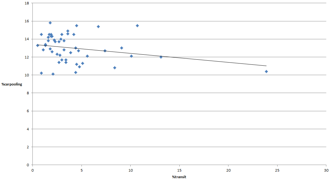
Transit mode share vs carpooling mode share (source)
So, argument over? We should just cancel transit investments and focus on incentivizing carpooling instead?

Yeah, not really.

Why carpooling is not a replacement for transit

Don't get me wrong, carpooling is a great idea if you can manage it in your schedule. However, carpooling is a very inflexible mode of transport for the passenger. Essentially, carpooling is like a bus line that has only two stops and that runs once in the morning in one direction and once in the evening in the other direction.

Schedule of a bus line versus "schedule" of a carpool, which do you prefer? (Yes, I use 24-hour time)
So, in essence, all single occupancy car trips can be seen as potential carpooling lines, or even as some kind of express bus. In order for carpool to be a valid choice, you need:

A- To have the same origin and destination as another trip, or to be easily on the way
B- To need to leave in their morning at roughly the same time and to come back at roughly the same time too

Considering sprawl and the fact that arterials tend not to be residential (even worse for freeways), these two conditions are quite hard to fulfill. The time when they are most likely to be fulfilled is for the commute, as this is when the most trips are happening at the same time.

But wait, that's not all, with a bus line, if you miss one bus, you can take the next one, if you miss the carpool, you're screwed. If you want or have to stop somewhere while going to work or coming back home, it's hard to do it while carpooling, the passenger is captive of the schedule of the driver. Even worse for workers who have variable work schedules, which is more and more common. What if the driver has no overtime but the passenger has to stay at work 1 hour more to finish some task?

So it's no surprise that carpooling is largely fit only for a minority of people who happen to have very stable work schedules. Transit on the other hand has plenty of trips, allowing for much more freedom of movement.

So carpooling is not appropriate in most cases... at least it's still much more economical than transit, right?

Well... not exactly.

The big issue here is that, as I said, carpooling is not flexible at all, and commutes are just maybe 30% of people's trips. So if there is no transit in a car-dependent area, what does the passenger of a carpool do when he has to go somewhere else than at work? Well, in the end, he still has to own a car for when carpooling is unable to satisfy his mobility needs, which is most of the time. So carpooling doesn't eliminate the need for cars the vast majority of the time, and the basic fact about cars' costs is that fixed costs are very important, so not using your car doesn't cut down on costs all that much. Yeah, you save on gas and maintenance, and sometimes on parking and tolls, but the depreciation of the car is still there.

As I showed in a previous article, the cost per mile driven of a car varies greatly with the amount of miles driven, according to the AAA and CAA:

Cost in cents per mile per annual mileage, in blue the AAA, in red the CAA
So let's take one example of a 3-people carpool versus a case where everyone drives alone. If everyone drives alone, then each car is driven 10 000 miles a year, at a cost of 0,80$ per mile. But if they carpool, then one car still drives the same amount of miles and costs the same, but the two others are driven over 30% less miles, with costs per mile driven increasing to 0,95$ per mile.

So, what happens to costs?
Summary of miles driven and costs for the two scenarios
So overall, there is a cost reduction, but not as much as you'd think. Though miles driven are reduced by 20%, the total costs are reduced only by a little over 11% because of the fixed costs of ownership of the cars not used during the carpool.

Of course, you can make the argument that transit can also be the victim of this dynamic. However, as transit is a network with all-day service most of the time, the possibility of people to opt out of owning cars is much higher than with carpooling for the commute. And transit remains spatially more effective than cars even with carpooling. Even a bus with just 10 passengers occupy half as much road space as a car with 2 occupants. A bus that is full occupies nearly 6 times less road space than a car with 4 occupants.

So overall, transit can be a competitor to car ownership and travel the way carpooling can't really be.

Oh, and BTW, about carpooling declining with rising transit use, that is a mistake. Carpooling doesn't decline as a proportion of car trips as transit use increases, if carpooling has a lower mode share, it's just because CARS as a whole have a lower mode share.
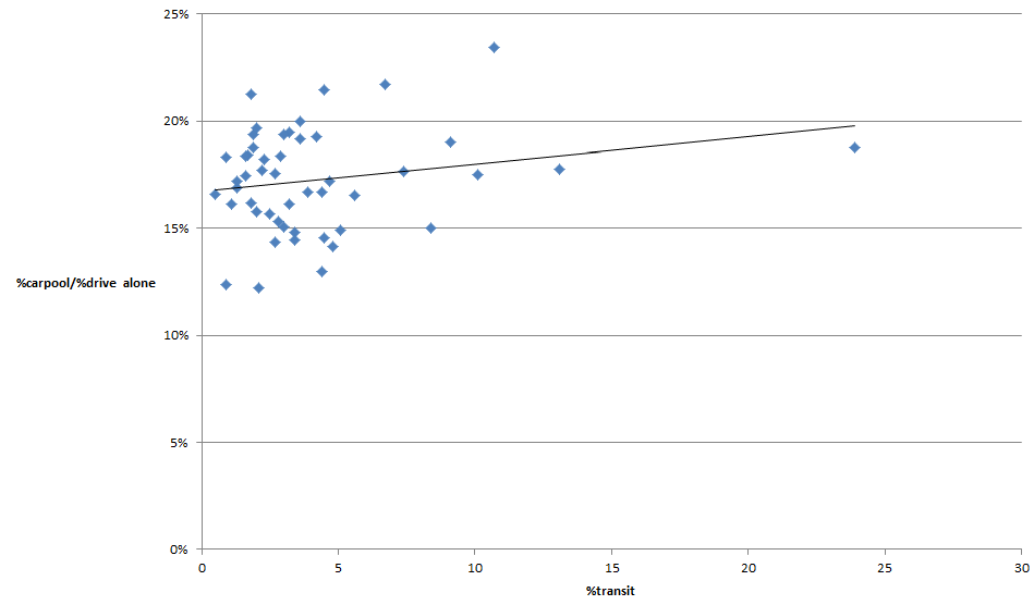
Transit mode share versus the proportion of carpooling mode share over driving alone mode share
Another fact that pops up when looking at the data is that congested cities don't necessarily have higher carpooling mode share. Which underlines that private vehicle occupancy is not impacted much, if at all, by congestion. In other words, you can't trust increased carpooling to deal with congestion.

What about slugging?

There is a final argument for carpool: slugging. Slugging means having people drive to a park-and-ride parking lot somewhere, park their cars there then get picked up by other people to do the rest as a carpool. Theoretically, it can help ease the problem of coordinating trips by moving the origin of the commute to a common parking lot rather than people's homes.
Traditional carpool, Blue goes from his home (Blue dot) to Red's home (Red dot) then both continue to a common destination

Slugging: both Blue and Red head to a parking lot, where Red parks his car and continues with Blue to the destination
This can help indeed to make more carpooling possible. But it may cause capacity problems near the parking lot due to the high number of vehicles going there and picking up people. But the biggest flaw of this approach is that if you have a park-and-ride parking lot... why not simply serve it with shuttles instead of relying mainly on carpooling? Just run a bus from the parking lot to the destination, then both Blue and Red can leave their cars there and board a shuttle bus. This kind of express bus is very economical as they have few stops and tend to have higher occupancy, the AMT runs express buses for less than 0,30$ per passenger-mile in Montréal. This also reduces even more the need for parking and road capacity in areas with high job density.

Conclusion

So, what of carpooling? It certainly beats driving alone, so if you are one of the lucky ones that can use it, please do, and favoring people who carpool with HOV lanes is very defensible. However, carpooling alone doesn't solve the issue of carless mobility and its economic benefits are overestimated by neglecting the fact that carpool passengers still largely need to own cars on the side. If anything, transit may be complementary to good carpooling option as it gives a fallback to passengers if their ride doesn't show up.

Monday, February 2, 2015

The common origin of North American suburbs and Soviet towers in parks

So I read an article recently about the "Soviet City", (http://www.newgeography.com/content/004830-looking-back-the-ideal-communist-city) which made a link between the Soviet city planning and the urbanist movement. The author noted that, like urbanists, Soviet city planners were focused on walkability and transit, and sought density, building big concrete apartment blocs. She said that they were imposing their vision in an authoritarian manner, contrasting this with North American suburbs, that she describes as emerging organically from the desires of consumers. The whole piece is meant as a warning against urbanists not to impose their vision on an unwilling population.

You may consider this post as a rebuttal. I believe that despite the author's claim, both North American suburbia and Soviet suburbs (yes, they were suburbs, not cities) share many basic design points.

First similarity: both were planned from above and imposed on the population

The most glaring error of the text is that it supposes that North American suburbia is a spontaneous emergence from consumer preferences. The reality is very, very different. Though the United States as a whole likes to boast of capitalism and property rights, in terms of development policy, it is one of the most controlled countries in the world.

American elites in the middle of the 20th century were clear about their vision for the future of the country. The American Dream would be about owning a house on a plot of land, with cars to travel around, like a miniature version of the estates and villas of the rich. Renting was out. Mixed use was out. Multifamily housing was out... even outright "un-American" according to some of these elites.

As a result, American cities and governments adopted strict policies to make almost anything that wasn't suburbia was harder and more expensive to build... if not outright impossible.

Cities implemented Single-Family Detached (SFD) only zoning, forbidding anything else but detached housing in most of their area. Any attempt to convert houses to multifamily housing would face quick backlash from the defenders of this zoning. Regulations would mandate huge parking lots to make sure traveling by car was easy, even if they made walking, biking and transit very inconvenient.

The Federal Housing Administration offered mortgage insurance only to places that fit the standards of suburbia. Redlining, where whole areas were denied government-backed mortgage insurance, is often associated with race, but it was also singling out urban areas, based on ideas regarding urban planning that are opposed to best practices today (mixed use was wrong, street grids were wrong, cul-de-sacs were great, etc...).

Advantageous fiscal advantages were put in place for homeowners to make paying back a mortgage cheaper than renting.

Not only that, but State governments would destroy entire neighborhoods to run highways through cities to allow suburbans quick automobile access to entire cities, without which the suburbs would have been unable to sprawl farther as distances (in minutes) would be growing too great to support the sprawl. These highways would be free of charge to use, subsidizing suburbs that depend on them by using tax money from other areas. Transit would choke faced with this subsidized competition.

Canada has a bad tendency of doing whatever big brother America does, so much of these policies were imported North.

Of course, in a time of great population growth (the babyboom and mass immigration), when you destroy urban housing for "urban renewal", ban new urban housing from being built and subsidize sprawl, it is no surprise that sprawl is what gets built and where most people start living in. Whether or not there really was consumer preference for this type of housing, we will never know because of the imposition of that model and its subsidization. Price is part of consumer preference, an essential part of it, by subsidizing a certain lifestyle and increasing costs of other lifestyles, you change what consumers will opt for.

Second similarity: Soviet suburbs and North American sprawl are built based on the same anti-urban modernist ideas


If you only look at buildings, there seems to be no similarity between North American suburbia and Soviet suburbs.
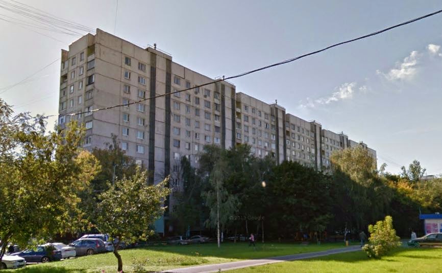
Typical Soviet suburban apartment bloc
Typical older single-family home of US suburbs
However, even if the Soviet example is very dense, very tall and is multi-family housing, that alone doesn't make it an urban form of development. In fact, the Soviet example is an accomplished case of "tower in the park", Soviet suburbs are often full of greenery with blocs facing trees rather than each other. Just like the detached single-family homes of North America are separated by distance and often use trees to isolate themselves from other buildings and the street.


Both the single-family home of North American suburbs and the apartment blocs of Soviet suburbs are designed to be isolated, to provide a feeling of being close to nature, not to a city. In order to achieve that effect, they use green buffer spaces next to the building on its lot so that other buildings are reasonably far away. In fact, both house and apartment building share the same basic design of a building in the middle of a lot, kept at distance from other buildings:
Basic design of a typical US SFD home
Basic design of a Soviet apartment building
In fact, take a typical villa-type SFD, stretch the lot to make it bigger then build one big building that is essentially homes built side-by-side and one over the other, and you have the Soviet apartment building. In both cases, some kind of isolation is the result, as the units over the ground floor are effectively isolated from any activity on the street. As opposed to single-family homes built with only small setbacks and low-rise apartments with balconies built next to the street, which are less isolated from the street.

Green buffers are used to destroy the urban fabric, meaning the appearance of a dominance of built areas in cities, of buildings forming a coherent whole, enclosing the street and public areas (bringing buildings in contact with the street). By creating these gaps between buildings and filling them with greenery, the goal is to make "natural" landscape dominant, as if one was walking in a park or a forest, not in a city.

Note that this use of green buffers isn't an efficient use of space, not at all. In the case of SFD homes, it represents a huge waste of space that reduces density to a minimum and forces all trips to be motorized. Only mass motorization and the subsidization of high-speed roadways can allow such waste of useful land to go on. And indeed, US suburbs MANDATE that waste. Residents and pro-sprawl planners react with holy terror when the rules that impose green buffers (mandatory setbacks, minimum lot sizes, etc...) are questioned, because they know that without them, many lot owners would seek to make the green buffers productive by building on it, and it would raise the value of land, making the big estates they like more expensive.

In the case of the USSR, I think it goes without saying that this waste of land was also mandated by the government. However, as the USSR was much poorer and planners knew that they would need to rely on walking and transit to move around their population (another nail in the coffin of the canard that cars are cheaper than transit), they still insisted on density, resulting in very tall buildings full of small housing units. That way, they could match the older, dense neighborhoods while maintaining the green buffers. But while they managed to salvage spatial efficiency by doing so, they sacrificed housing affordability as tall buildings are more expensive to build, even the cheap, mass-produced stuff they built. To compensate, they made the housing really, really cramped. If your housing costs twice more per square foot to build, just build units twice as small, right?

It seems to me that everywhere green buffers are abundant, it has been mandated by government in some way. Huge setbacks and distances between buildings is simply not an economically efficient use of space, it is wasteful, so the only way to make sure it remains frequent is to require it.

What does a city that doesn't mandate green buffers and allows individuals to do what they want with their property looks like? Look to Asia for the answer (but not China, which is also planned like the USSR, even if it's less "tower in the park"-y in some places). People are probably getting tired of me bringing up Japan, so here are:
South Korea...
...Thailand...
...and Taiwan
You can also look at old European villages, which have a lot of similarity with Asia. In any case, these loosely regulated cities are completely different from both North American suburb and Soviet suburbs. They have strong urban fabric and could even be called buffer-less cities. Motivated by economic reasoning, they have created dense cities where buildings are built very close to one another, which only rise to the skies when the demand for it is actually there.

Conclusion

So I hope that I have made a convincing argument that North American and Soviet suburbs actually both originate from modernism that rejected traditional cities and wished to tear apart the urban fabric, using green buffers to isolate buildings and people, and try to create the impression of living in a park or a forest rather than in a city. In both cases, the government used different tools to impose the vision of their elites on their population, often until the population just figured this was how things are and always will be. So they are two flavors of the same idea, not two diametrically opposed ideas, and the differences there are were largely dictated by transport needs and wealth level.

I'm not saying that such suburbs are terrible and should be banned. Some people do crave the isolation they bring about. I do not resent their choices. However, I don't think that these preferences should be imposed on people nor subsidized by having everyone pay for the transport infrastructure this kind of development requires to be viable. The idea that North American suburbs emerged organically and represent consumer preferences perfectly also needs to be confronted. It is incorrect, it is a myth, and the fear of development deregulation by promoters of sprawl shows that even they acknowledge that without these regulations imposing sprawl and the subsidies distorting price signals, a lot of people would opt out of sprawl.

Sunday, January 25, 2015

Highways and boulevard: a capacity-cost analysis

I recently compared urban freeways to subways to demonstrate how they are not a cost-effective way to quickly transport great amounts of people in urban areas. However, that comparison involved very expensive and high-capacity infrastructure, that not that many cities need or can fully utilize. Many cities are also much less dense, so they may find it easier to build surface highways that can be much cheaper than the trench highway I used in an example.

So, let's see if highways make sense as a main transport infrastructure for urban developments. I will do so by comparing surface highways with urban boulevards, their cost and their capacity. But first, I must address something

Why the focus on capacity?

Some people who read this may find my choice to focus on capacity rather than, say, speed to be annoying, or even in bad faith. The choice of capacity as a metric of performance, despite capacity not being that relevant to the end user (its relevance largely limited to its effect on speed when congestion occurs), is justified by the fact that transport capacity ultimately impacts and limits development. One of the main reasons to oppose new developments by politicians is the fear of congestion, that transport infrastructures will be overwhelmed by the new developments and make current transport patterns much harder, if not impossible, to maintain. This leads to traffic impact assessments and traffic studies (which I plan to criticize in another article one day).

So lacking transport capacity caps developments, if transport links have reserve capacity, it is easier to develop areas and to increase the number of residents and jobs in an area. As such, for cities, it would be wise to seek ways to cheaply build transport infrastructure that have high capacity, to reduce the cost of infrastructure to sustain a given population.

OK, let's get started

Now, when I talk of "highway", I refer to grade-separated motorways that have no intersection, just interchanges, so as to maintain a constant speed without requiring vehicles to stop on their trips. These roads bear different names in different places in the world: motorways, expressways, freeways, highways, etc... So let me be clear, THIS is what I'm talking about:

This is an highway: wide roads without intersections, with accesses limited to ramps.
On the other hand, when I speak of boulevard, I mean roads that are straight and built for higher capacity but which have many intersections, often controlled by traffic lights. They have sidewalks, often with buildings built on them and occasionally have bike infrastructure on them.
This is a boulevard

So is this
And this
Boulevards can have different typologies, there are urban boulevards which have a relatively narrow pavement width with large sidewalks and buildings built right next to them, and there are some boulevards that are what Charles Marohn at Strongtowns calls "stroads", built with highway-like standards... but still with frequent intersections and traffic lights rather than interchanges. All are boulevards, even if the areas they serve differ. Though my comparison will mostly consider well-designed urban boulevards rather than awful stroads, the same conclusions apply.

Cost

So, the first issue is, what do they cost? There is no easy answer for highways. Highways in flatlands in rural areas can be relatively affordable, I've seen some built for about 20 millions per kilometer (30 millions per mile), sometimes a bit less. However, surface highways built in urban areas are more expensive than that, for example, the A-19 in the suburbs of Montréal is expected to cost about 600 million dollars for 9 kilometers, so a bit over 60 millions per km (around 100 million dollars per mile). This is generally due to the cost of land acquisitions and the cost of more frequent interchanges and highway bridges that need to be built.

Elevated highways are even more expensive, maybe around 200 millions per km (320 millions per mile) and underground subways are monstrously expensive, with prices frequently approaching or going over one billion per mile (see Big Dig). Again, interchanges are massively responsible for these costs, a single interchange can cost 50-60 million dollars.

As to boulevards, their costs vary much less, mainly with the number of lanes and how much money may be spent on beautification. Recently, a roughly 3-km length of boulevard was approved in Montréal, the boulevard itself is budgeted to cost 15 million dollars, so 5 million per km (8 million per mile)... and the interchange that will connect it to an highway will cost 60 million dollars.

So, overall, I will assume a cost of 50 millions per km (80 millions per mile) for an urban 4-lane (2 per direction) highway built on the surface in a low-density urbanized setting, and a cost of 5 millions per km for a 4-lane boulevard.

Capacity

The capacity of an highway lane is around 1 600 to 1 800 vehicles per hour. Some highways see as high as 2 000, but they are the exception. In general, congestion will occur at interchanges.

Meanwhile, the capacity of a lane on a boulevard is much lower, around 800 to 1000 vehicles per hour. The reason for that is simple: since they have intersections and some of these intersections will be with other highly-used boulevards, cars on the boulevard may only have the right to cross the intersection half the time. Intersections serve as bottlenecks. A boulevard without intersection would have the same capacity as an highway... and would essentially BE an highway.

Supposing a standard occupancy of 1,3 person per vehicle, that leaves a capacity in persons per per hour per direction of:

4 600 pphd for a 4-lane highway
2 600 pphd for a 4-lane boulevard

So an highway has around twice the capacity of a boulevard... HOWEVER, it also costs 10 times as much per km. The result is that more boulevards can be built for the same price. So you're not comparing one highway versus one boulevard, but an highway versus a GRID of boulevards.
2 highways intersecting in a city, or...
...a grid of boulevards, each separated by 500 to 1 000 meters (1 600 to 3 200 feet)
Vehicle capacity on boulevards is thus 5 times cheaper than on highways. 

BUT WAIT, there's more...

I've been only considering capacity for cars here, but there are other modes of transport. Transit, bicycles, walking, these are ways of getting around too.

For example, if we have a bus line with 20 regular buses per hour, with each bus carrying as many as 60 people. That means a capacity of 1 200 pphd in transit. Use articulated buses instead and it's up to 2 400 pphd. Even better, have a local line and an express line on the same boulevard with different stops, and you can have two lines superposed on one another, doubling capacity. Transit will occupy some space on the boulevard and reduce somewhat vehicle capacity, but this impact is very low due to the spatial efficiency of transit.

Providing a simple 3-meter bike path (10-foot) can also get you about 1 000 pphd on bikes, widen that path a bit and you can double that to 2 000 pphd.

And sidewalks have very high capacity, with decently sized sidewalks on both sides, you could maybe get as high as 4 000 pphd on foot.

However, that's only valid for the boulevard. Cyclists and pedestrians are outright banned from highways, even if they did want to travel there (and they wouldn't). Highways create a big wasteland around them to achieve object clearance zones (or recovery zones), and their high speed favors distant, sprawled out developments that means that even if you decide to build footpaths or bike paths alongside them, no one would use them.

As to transit, though buses can certainly travel on highways, they cannot SERVE them. Vehicles are not supposed to stop on highways unless they have a malfunction. And even if they could, highways are off-limits to pedestrians. AND even if they weren't, highways rarely have walkable developments at interchanges, so the use of such buses would be limited, if not completely inexistent. So only express buses traveling long distances can really use highways.
Example from Houston, buses use parallel roads instead of the freeway to go downtown
Still, you can use highways for express buses, shouldn't that count? Well, no. Because you can do the same with boulevards too.

So what does this mean? This means that the capacity of highways for transit is 0, for bikes is 0, for walking is 0. But boulevards, as they are space efficient and closer to developments, can easily support all these modes of travel.

So in the end, a proper comparison leads to this graph, comparing a 4-lane boulevard with a standard high-frequency bus line and bike path, a 4-lane boulevard with a high-frequency articulated bus line and bike path, a 4-lane boulevard with a tram using 2 of these lanes (thrown in just for fun) and a 4-lane highway:
Comparison of capacity between different boulevards and an highway

Or, if some protest about including bikes and pedestrians, fine, just motorized modes:
Comparison of capacity between different boulevards and an highway, motorized modes only

Note that I'm even low-balling transit here. You can get up to 10 000 pphd with transit on a transit-only lane if you use big vehicles and very high frequencies. And with wide enough bike paths, you can double that bike capacity.. and maybe even triple it.

So even a simple 4-lane boulevard with a bus line using regular buses can nearly match highway capacity, without including bikes in the total.

So that means that boulevards can support much more development than highways, especially urban-style development that allows trips to be made on foot or on a bike, and all for a fraction of the costs of highways.

What about speed?

OK, now let's talk of speed a little. Yes, highways allow much higher speed. A car traveling on a boulevard will travel at a speed on average between 25 and 35 km/h (16 to 22 mph), compared to an highway's speed of 100 km/h or more. Transit is even slower, at an average of 15 km/h (around 9-10 mph) for local buses, trams and BRTs can increase that to 20-25 km/h. Bikes go maybe on average at 15-20 km/h.

However, it's important to point out that since highways are so expensive and take so much space, people rarely live right next to them. Even cities with plenty of highways like Houston spaces them by 5 or 6 km between them (3,5 miles), whereas grids of boulevards can have boulevards every 500 or 1 000 meters apart. So getting on an highway may take an average of 5 minutes, likewise, getting from the exit to the destination may also take another 5 minutes. Getting to a boulevard is a much simpler affair, maybe needing only 1 minute of driving, with destinations often right on the boulevard.

As a result, the average speed of highways for urban trips isn't that much higher than on boulevards:
Average speed of trips using boulevards or highways, depending on distance, once we take into account the time to access the road
The average commuting distance in the United States is around 8 miles, or 13 km. On such a trip, an uncongested highway saves people only 10 minutes versus an uncongested boulevard. But as I demonstrated, highways are more likely to congest due to their high cost and low capacity, so it doesn't take much congestion to make that advantage nearly vanish.

So boulevards do not support the unending sprawl that highways do as they are not as fast, but they're not that slow either. The average commute is 25 minutes in Canada and the US, supposing an average of 30 km/h for boulevards, that means 12,5 km. If you use that distance as the maximum tolerable distance from the downtown area, that represents nearly 500 square kilometers of areas close enough to downtown to tolerate urban development. With a pretty average density of 1 500 people per square kilometer, which is Riverside's overall density (not exactly the world's densest city), that means 750 000 people can live in that area. With the density of Los Angeles, so around 3 200 people per square kilometer (again, not exactly the densest city in the world), that would be enough for a city of 1,6 million people. With the density of Montréal, so 4 700 people per square kilometer, that would be enough for 2,35 million people. With European- or Asian-style density, you could house a city of 3 or 4 millions in that area.

Conclusion

I think it's pretty clear that highways are the wrong tool to deal with urban transport issues. They are too expensive and their speed is not actually required for most urban trips. They may still be justified to respond for the need for speedy long-distance trips however. Again, it justifies my point of view of not building highways in urban areas, or only a few 2-lane highways with high tolls to discourage urban trips from using them needlessly, in order to preserve their speed for long-distance trips and freight which actually need the speed.