Tuesday, June 16, 2015

In defense of use separation

How's that for a clickbait title? No, it's not a late April First joke either.

One of the first advice people will read from urbanists is a strong recommendation in favor of mixing uses. It always comes back, however, it is not actually very clearly defined what "mixed use" means, or rather how close must uses be before we consider that they are mixing?

For example, all would agree that the following pattern (green=residential, red=commercial/industrial) is not mixed, as the two uses are grouped together with a buffer (white) between each:
Clearly not mixed
 On the other hand, the following pattern, all would agree, is mixed:
But what about the two following patterns, are they mixed or not?


It's easy to find the first pattern, just check out any cities in sprawl, with stores and industries gathered around highway interchanges and endless exclusively residential areas beyond that:
Search for "stores" near Atlanta, the center of the image is all residential (the stores in the area are mainly false positives or home businesses), stores are concentrated at highway interchanges
However, the second pattern is found next to nowhere. The idea of having stores equally distributed in a city seems to make little to no sense. In some very dense cities, you do have small stores here and there, but most stores still gather in nodes or on certain arterial streets, and offices tend to concentrate in some areas too.

Even in the densest cities, like Barcelona, this tendency for commercial uses to group together is easily seen:
Barcelona, stores in red, restaurants in green, some nodes and corridors identified
Good example of the linear pattern, Montréal's Plateau-Mont-Royal borough, the vast majority of stores located on a few streets, with only a few lone stores located elsewhere, 70% of local trips are done on foot or on a bike

French village, typical example of the central node pattern
So again, what does "mixed use" mean? Clearly, we have plenty of successful cities where uses are separated, in fact, it is hard to find someplace where uses aren't separated to some extent, resulting in active commercial areas and sleepy residential streets, even in the heart of cities.
St-Laurent Boulevard in Montréal, every building is commercial or office
1 bloc away from St-Laurent boulevard, all buildings are residential
A commercial street in Manhattan, again, nearly everything at street level is commercial
Mainly residential street in Manhattan

Mixed use buildings

Some could point out that there are mixed use buildings, especially common in the highest density cities in the world, like Barcelona and Manhattan. The classic mixed use building is quite simply a commercial ground floor with residential apartments or offices on the upper floors, a type of building very common in the world's densest cities.
Mixed use buildings in Barcelona, store fronts on the ground floor, apartments above
These can be seen as an evolution of the traditional urban houses of earlier times, where people lived in the same building in which they worked, in the rooms on the 2nd floor or above, while the ground floor was reserved for their economic occupation, whether it be restaurant, a small office or even a small workshop.

But is it really mixed? Yes, there are 2 or more uses per building, but it is not mixed evenly in the buildings, there is a clear pattern. Commercial uses, if present, are always on the ground floor, I've never seen a building with residential units on the ground floor and commercial uses on the upper floors. We could even talk of vertical use separation.

Why do uses separate?

So clearly, these patterns seem pretty universal, whether a city is planned or not, there is a phenomenon wherein uses will tend to separate. Why is that?

I think the main reason is that locations are not necessarily universally desirable for all uses. In fact, desirability for a given location often varies wildly depending on perspective. If we think about it, we might identify a few desired features of each use.

Residential: people typically want their housing to be located near to transport infrastructure and to stores and services, HOWEVER, people also want privacy and quiet for their residence. Which means that highly-trafficked streets are not desired by residential uses as it results in a lot of noise and may affect privacy, especially for the ground floor. Residential uses therefore want some buffer with main arterials, whether that buffer is horizontal (located on a side street for instance) or vertical (once you're high enough, you're no longer as affected by noise nor do your perceive traffic so much). Once upon a time, before elevators, higher units would be undesirable because of the stairs, but with elevators, that's a moot point.
Residential desirability, per floor, in relation to an arterial (the large black road), red=undesirable, yellow=slightly undesirable, green=desirable
Note that this desirability manifests through prices. For having shopped for a condo recently, I can tell you that the higher the floor, the higher the price, and that ground and basement units are significantly cheaper (yet remain on the market longer).

Commercial: Stores and other commercial offices tend to have a mirror desirability to residential uses. Though both residential and commercial want to be near one another, people choosing their residence flee from traffic and noise, while stores are drawn to them like moths to a flame. Well, noise is not desired but commercial uses are often indifferent to it. Traffic is crucial because the best publicity is being on the way of thousands of people's daily trips. Whether that traffic is pedestrians, cyclists, drivers or, sometimes, transit users, it doesn't matter. The important thing here is VISIBILITY, the opposite of privacy. The more people pass in sight of a store, the higher the potential for pass-by trips. Unlike residential uses, the higher the floor, the less visible it is, so the less desirable the location.
Commercial desirability, per floor, in relation to an arterial (the large black road), red=undesirable, yellow=slightly undesirable, green=desirable
Note that commercial uses want traffic, but they also create traffic. Indeed, the best way to attract life on a street is to have plenty of commercial uses there. So commercial uses will tend to congregate to benefit from each other's traffic, and to create city-wide visibility for that commercial area, to generate more traffic. At the same time, this traffic will tend to push away residential uses.

Offices: offices are workplaces where plenty of people work. often on fixed schedules. As a result, offices generate a lot of trips in the peak travel periods, but they require little to no freight to operate as they produce services, not goods. Offices don't care much about visibility or privacy in general, though noise may be distracting for employees, they don't have much pass-by clients, and even less pass-by employees! People using their services generally learn of their existence through other means (internet, business contacts, etc...). What offices want most of all is to be located at nodes of regional passenger transport links. That way, they have access to larger pools of potential employees and they don't have to fear lost productivity due to congestion getting to work. So they will tend to mass around transport nodes, public transport or highways.
Office desirability, per floor, in relation to an arterial (the large black road), red=undesirable, yellow=slightly undesirable, green=desirable

Like commercial uses, they sometimes have an advantage in congregating together, because sometimes offices require each other's services. Also, in the modern world, with job security on the decline, the concentration of industries in given nodes allows to mitigate the effects of changing jobs. Having your contract not renewed is bad, but if you have half a dozen other potential employers within a 10-minute walking distance, at least you can hope for not having to move your family to accommodate your next job.

Since offices generate quite a bit of traffic, commercial uses may be attracted to them too.

Industries: Industries are a bit like offices, with high peaked traffic, though generally not as high, especially with modern automation. However, unlike offices, industries depend a lot on freight, so instead of desiring locations near nodes of passenger transport links, they want to be near nodes of freight transport links: train station, ports, interstate freeway exits. Most industries rely on just-in-time transport, so unreliable freight, including due to congestion, is highly undesirable for them and they may move out of areas if freight becomes too unreliable. Unlike all the other uses, industries will not particularly favor urban areas, industries take too much space, which is expensive in cities, and they don't benefit from traffic. They still want to be reachable to employees, but they can be satisfied with being out of the way and accessible by shuttles, because transport demand is highly predictable and limited in time.

Note that when freight and passenger transport links overlap, like on highways, this can create tensions between industries and offices who can then go after the same locations, submerge them with congestion, which pushes industries ever further out.

So to sum up, each use favors different locations. So in a completely free development context, we could expect uses to separate over time anyway following a certain logic. Some uses will still favor proximity to one another (residential and commercial uses mostly), but they will tend to maintain some buffer, whether horizontal or vertical, with one another.

So what does it all mean?

What this reasoning would entail is that use separation can be expected to be a spontaneous reaction and is not necessarily bad.
Though Japanese zoning allows many different uses in its commercial zones, this area near Shinjuku station is almost exclusively commercial and offices, with stores and offices occupying all the floors of 6-to-8-story buildings
Uses can be separated, yet still be in proximity with each other, such as the traditional commercial arterial of streetcar suburbs, with residential side streets. This also means that it is theoretically possible for very competent planners to predict where uses will gravitate to and use an exclusive zoning system to shape developments in a way that they would likely have evolved into anyway. However, this really requires excellent planning skill and constant revisions of zones to provide for sufficient supply of land to respond to evolving demand.

So we get to a final definition of "mixed use", a regulatory one. A zone can be called "mixed use" in urban planning if it allows for multiple uses within it without regulatory oversight. This is ideal because it creates a margin of error for planners. With exclusive zoning, planners need to be able to predict exactly how demand for the different uses will evolve. If they do not, then they create artificial land shortages for a type of use and over-supply of land for other uses, which unbalances cities and their local economies. A sadly too typical response in these cases is building new roads to open up new lands to solve the shortage rather than review current zones.

With mixed use zoning, uses can grow inside each other's zones, at least in certain areas zoned for mixed uses. This mitigates the problem of zoning and reduces the need for hyper-competent planning (which is a beast as rare as unicorns).

Conclusion

What is "mixed use"? There is no one correct definition, everyone could debate on how close is close enough before uses are considered to be "mixing". And anyway, left to their own devices, uses are quite likely to separate and congregate on their own, as each use favors different types of location. The important thing should be proximity and scale. You can have a city where uses are separated, as long as these uses are separated based on a human, walking, scale and not on a "highway-driving car" scale, that way, uses can remain in close proximity to one another, when it is beneficial for them.

The most important aspect of "mixed use" is the regulatory one: if zoning is used, zones should allow for multiples uses inside them, to provide margins of error to planners and their inevitable failure to predict correctly evolving demand for the different uses. If regulations don't allow for mixed uses, then it will inevitably create shortages of land for some uses and over-supply for others, creating distortions in the economy and failing to allow communities to grow so as to respond to their own needs.

Saturday, June 6, 2015

How modern zoning affects land value and incentivizes sprawl

As I already pointed out, in any economy (be it socialist, capitalist, feudal, etc...) that uses money, the price of goods sends signals to consumers and guide their consumption. In terms of development, the value that is most crucial is land value. If land is cheap, then it sends a signal that land is abundant and it can be wasted without fear of bankruptcy, which results in low-density developments. If land is expensive, then it signals developers to build higher densities because land that desirable is rare. Land prices are what motivates high density developments in a housing market with little regulation.

But that still leaves one big question: what determines the value of land?

The answer in the end is that the potential profit from developing the land determines its value.

So if housing is in short supply and so has high prices, then the potential profit from building new housing is likely to be quite high. If the market tolerates higher densities, likewise. So without urban regulations, desirable locations would support higher-density developments, which would increase land prices and so squeeze out low-density developments in that location for all but the super-rich.

OK, so that's that, but what are the repercussions of this? How does this contribute to shaping cities?

How zoning and density limits make low-density more affordable and high-density more expensive

First, let's use a thought experiment with approximate values. Let's look only at housing, specifically five types of housing: high-rise apartments, low-rise apartments, townhouses, small detached houses and big detached houses...

The five housing types of the thought experiment
Now, all of these housing types generate income, profit for the developer who builds and sells them. From the FAR (Floor Area Ratio), I will estimate some relative income per square meter of land used to build each housing type, knowing that bigger houses with bigger lots may tend to have more of a profit margin relative to building cost.

So if the large detached house has a relative profit level of 100 per square meter of land, the smaller detached house would have a profit level of 145, the townhouse would have an index of 190, the low-rise apartments, an index of 250 and the high-rise, an index of 840.

By that, I mean that a small detached house would yield 145% of the profit of the large detached house per square meter of the lot area, so 45% more.

Now let's try a first scenario, where there is no zoning and no planning, let's assume a uniform value of land everywhere (a simplification that may be valid for a small neighborhood), a value made by averaging all the indexes of each allowed building type. I supposed a construction cost of 1 500$ per square meter for all units, except high-rises that cost 2 500$ per square meter (divide by 10 for square foot, not exactly that, but close enough approximation), and I supposed that the unit size are 200 square meters for the big house, 160 for the small house, 120 for the townhouse, 90 for the low-rise apartments and 70 for the high-rise apartments.

OK, so enough with the methodology, here are the results, the market price for each unit type, per unit and per square meter of floor area.
Cost of each unit, per unit and per square meter of floor area, case 1: without zoning
So in this case, the lower density housing types are significantly more expensive, both per unit and per floor area, largely because they consume more land per unit and per floor area, which increases their cost as they pay the same price for land as higher density developments. This provides a financial incentive for higher densities, people who desperately want lower densities have to go farther away from desirable spots to find land that is more affordable.

Now, for CASE 2, what happens if we implement a simple zoning rule: one zone is limited to single-family housing (including townhouses, yes, they are single-family housing), the other is limited to multi-family housing. Here, land value is affected, in the SFH zone, single-family housing types no longer have to compete with high-density housing types, which generate more income per square meter of land, so land in that zone, deprived of the potential for higher profits, will be worth much less. I will average the indexes only of all single-family housing types for that zone. In the other, the opposite occurs, since the land where multi-family housing is allowed is limited and all the competitors for that land are all multi-family housing too, land value will likely be much higher there than it would be otherwise, I will average the indexes of low-rise and high-rise apartments only. 

So in the end, land in the SFH zone is worth 50% less, but land in the MFH zone is worth 80% more, which has a great impact on unit prices:
Cost of each unit, per unit and per square meter of floor area, case 2:single-family and multi-family separation

This is a boon for low-density housing, in the first case, the big houses cost 550 000$ to buy because of the price of land, which they require a lot of, in the second case, deprived from the competition of multi-family housing, the cost falls to nearly 400 000$. On the other hand, apartments become significantly more expensive, as they are left to bid up land prices in a limited zone with other highly profitable developments. Low-rise apartments suffer most, they cost about 160 000$ in the first case, but nearly 190 000$ in the second, they even become more expensive than big houses per square meter of floor area. Note that this experiment supposes that planners provide enough land for both housing types, if they give one the short end of the stick by restricting their zone area too much, they may create a shortage and drive prices up.

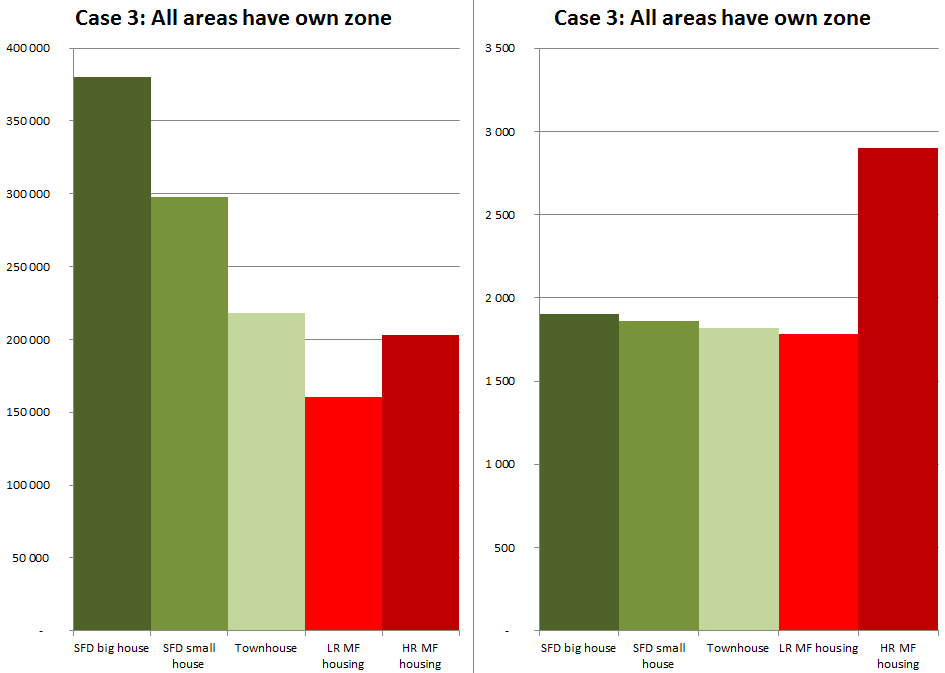
Now, let's go on to CASE 3; in this case, we go even further along in the separation of each housing typology. Each housing type has its own zone. Like in case 2, this favors lower-density housing types, which are protected from competing for land with other housing types, so land prices are lowest where only low-density housing is allowed, and highest where only high-density housing is allowed.
Cost of each unit, per unit and per square meter of floor area, case 3:all housing types have their own zone
In this case, the cost per square meter of each housing type represents the construction cost, not surprisingly. The big houses are now even more affordable than they used to be at 380 000$, however, smaller houses become more expensive than in the previous scenarios. Low-rise apartments, not having to compete with high-rises anymore, see their land costs fall significantly, which is a boon to them.

In this case, there is no financial incentive to economize land, because zones are built to make low-density housing impervious to the waste of their higher land consumption, since the zoning makes more profitable and optimal use of that land illegal. The cost of housing reflects only construction cost and unit size, the cost of land per unit is largely equal, no matter how much land each unit consumes.

For, CASE 4, let's look at case 2, but with an added regulation: a minimum lot size of 800 square meters (a bit over 8 000 square feet, or a fifth of an acre).

In this case, I assume that townhouses actually are semi-detached houses, two on a single 800-square-meter lot. Anyway, here, the minimal lot size largely impacts single-family housing, making the main cost advantage of smaller houses on smaller lots moot, further depressing land value.
Cost of each unit, per unit and per square meter of floor area, case 4: Single-family and Multi-family separation plus minimum lot sizes
The biggest victim of this regulation financially speaking is the small detached house, which becomes only marginally less expensive than the bigger house, and more expensive per square meter of floor area. An additional effect is a fall in FAR for apartments, who see themselves forced to have bigger lots, but no more units. This doesn't affect their costs much, because it represents a fall in potential profit from development, which reduces the value of land. In the scenario I conceived, apartment density falls by about 30%.

Now, a famous regulation for CASE 5, high minimum parking requirements, added to single-family-multi-family segregation.

I will presume only off-street surface parking here, not considering the alternative of on-street parking or of underground parking, which is extremely expensive (on average 30 000$ per space). This surface parking doesn't affect either detached house, because they have sufficiently big lots already to have driveways without increasing their lot area. However, this forces once again townhouses to become semi-detached houses in order to accommodate driveways. 
Two townhouses to the left become semi-detached houses to have driveways if they are required to have 2+ off-street parking spaces

One impact of this is that the density of low-rise and high-rise apartments collapses, as they are forced to consume more land to have parking lots for their residents. As a result, FAR of low-rise apartments fall from 90% to 60% and FAR of high-rise apartments fall from 210% to about 90%.
Cost of each unit, per unit and per square meter of floor area, case 5: Single-family and Multi-family separation plus minimum parking requirements
This is not so different from case 2, except that it hides a significant fall in density, which has little impact on price because even if housing types consume more land, that land is worth less than it would have since more profitable alternatives (ie housing with less or no parking) are illegal. In effect, this regulation may reduce density by 40-50%, and also reduces land prices by 40-50%.

But what happens if you presume no zoning, but only minimum parking requirements? That is CASE 6.

Here is the effect:
Cost of each unit, per unit and per square meter of floor area, case 6: No zoning, but minim parking requirements
Here, as lower-density uses are no longer protected from higher-density uses, prices for low-density housing are much higher, however, they are nowhere near the prices of the first case (without zoning nor regulation), because the higher-density uses are of significantly lower densities than in the case without parking requirements. Since profit per square meter of land is capped, land value is capped... at least until land shortages force all prices up.

For those who want a real-life example of how minimum parking requirements reduce land value, then look at page 10 from the High Cost of Free Parking. In the case of Oakland, parking requirements reduced land values by 33% and density by 30% just 2 years after implementation, which seems to indicate that my little thought experiment isn't so far from the truth.

So, to sum up:
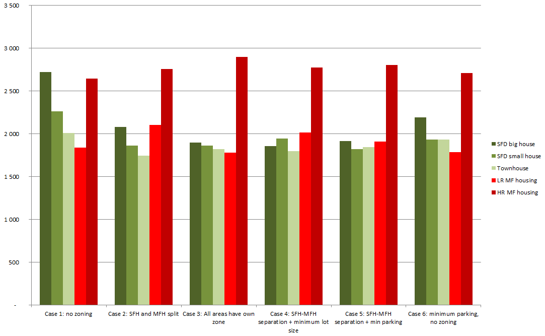
Total unit cost per scenario

Cost per square meter of floor, per scenario

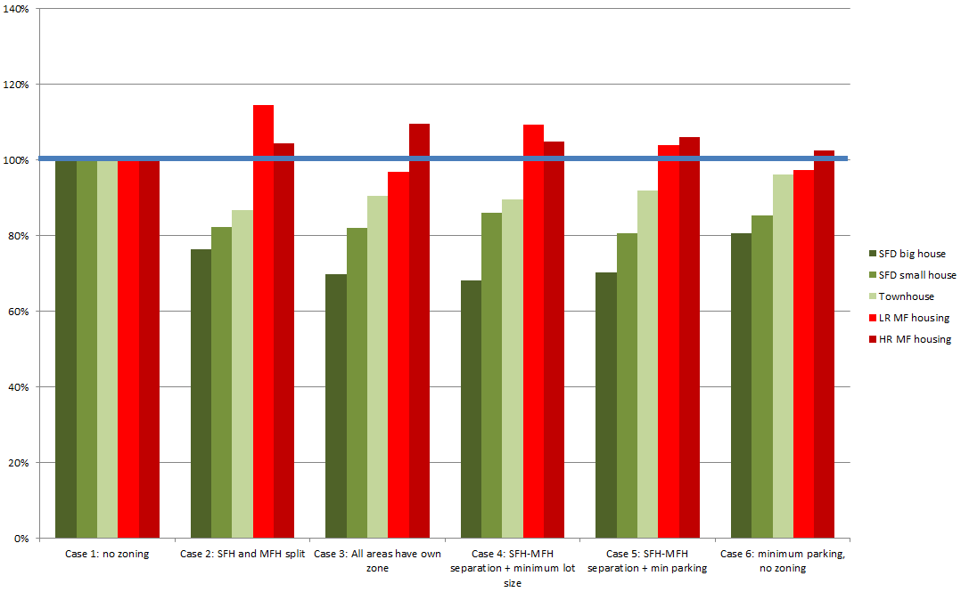
Cost variation, where case 1 (no zoning, no regulation) = 100%
So as you can see, zoning, minimum lot size and minimum parking regulations all create financial incentives for lower-density housing. They reduce the land cost of low-density housing by protecting them from having to compete with higher density uses for the land. On the other hand, they make high-density housing either more expensive or much less dense. As a result of these two factors, the average FAR that is built may go from 80-90% to 30-40%, because cheaper low-density housing incites people to buy more of them and higher-density housing's density gets limited. This results in population density falling by 3 or 4 times.

It's important to point out that though density limits make land prices fall, the price of housing overall remains largely constant because housing requires more land. So if land is worth half as much but you need two times more, then it has no effect on cost overall.

I guess if some want to push people into low-density housing, and don't care about financially sustainable and walkable communities, it doesn't matter much, or it may even be a positive effect of modern zoning and planning regulations. But for urbanists, this is a damning demonstration of the effect of modern zoning regimes.

Note also that though this effect is probably true, land shortages due to density limits will rise land prices overall, "a rising tide lifts all boats". But even if land prices triple or quadruple, zoning will still have the same effect of keeping land prices for lower-density options lower and encourage people to buy them This effect may seem paradoxical: density limits lower the price of land then increase them? But that is logical, in a situation of "plenty" with a lot of land to develop, density limits lower the value of land, in situations of shortage, where developable land is hard to find, the situation is reversed, density limits aggravate the shortage and so land prices.

That is why sprawl is dependent on highway construction to open up more lands for development. Since sprawl quickly fills out available land, if more land isn't found to develop, it will quickly choke in land shortages. So the solution of sprawl is to "create" more land, by making travel faster so as to bring developments closer and make land that used to be considered too far for development more desirable. This is the ideal of "mobility" of defenders of sprawl.

A couple of other caveat emptor:

1- I presumed that land value without zoning would average the different housing types, but speculators may actually hold off of selling their land until they can get the highest possible return on it (high-rises), so land prices may be even higher than expected. The solution to that is to make it more expensive to hold land by implementing land value taxation.

2- I presumed land value being uniform over the study area, but in reality, land values will vary from one neighborhood to the other, depending on their desirability. So in practice, absence of regulation may lead to highly variable land value depending on location, with high-rises going after highly desirable locations and shoving other housing types away. In extreme cases, I guess it could result in some kind of spontaneous separation of housing typologies.

Commercial areas

This conclusion is valid also for commercial areas, especially regarding minimum parking requirements. High minimum parking requirements which result in FAR of commercial areas of being just 10 to 20%, most of the rest being parking lot, significantly reducing the amount of revenue-producing area that can be built, since parking, if free, generates no revenue for the owner (but has expenses linked to it).
Commercial area in Phoenix, FAR of about 20%
Supermarket with parking lot in car-friendly Obihiro in Japan, FAR 50%
Though these regulations increase land consumption, they also reduce land prices. As a result, there is little effect on the overall price of building commercial areas, however, higher land consumption means a loss of potentially fertile land, more infrastructure and service costs and less tax base to pay that infrastructure.

Conclusion

As I've repeated a lot, in a money-based economy, prices represent information regarding resource consumption to guide consumers into wiser choices for themselves and the community. By protecting lower-density developments from competing with higher-density developments through modern zoning and urban regulation, this signal is distorted, prices are skewed in favor of low-density developments. This leads more people to choose that type of housing, even when higher density uses aren't outright banned (as they too often are). Forcing developments to compete on a level playing field would undeniably result in denser, more sustainable communities being built.

Thursday, May 28, 2015

On-site vs off-site parking and a Swedish model for suburbs

It is often said that one of the great advantages of cars, notably over transit, is that it offers door-to-door travel. You don't need to walk 5 minutes to a bus stop or walk 5 minutes from the bus stop at the end of the trip to your destination, you leave your front door, get in your car and drive to the front door of your destination, easy-peasy.

Except, this isn't actually true. Cars don't appear when people leave their home, nor disappear once at destination, they have to be left somewhere, in a parking spot. So, in fact, cars are parking-to-parking, not door-to-door. The only true door-to-door transport mode is walking, even bikes are parking-to-parking (and in some cases, bike parking can be even harder to find than car parking). Taxis I guess could be true door-to-door transport too.

In general in North America, planners and developers focus on providing plenty of parking for each individual building, with parking located near to the front doors, what can be called "on-site parking" (as in, the parking is on the same lot as the building it serves). This is one result of the off-street parking requirements, that has developers building the off-street parking on the same lot as the building, because that is the lot he can build on. Driveways, parking lots, even on-street parking (if not over-used) all serve that purpose of bringing cars very close to doors.
Driveways and abundant on-street parking help bring parking spots as close as possible to housing
Low-rise multi-family housing surrounded by parking
Sometimes, the focus on convenient parking location demonstrates little short of contempt for non-drivers:
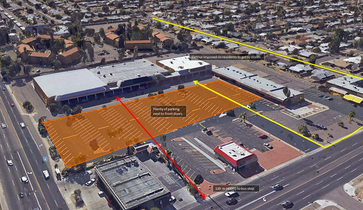
Typical North American strip mall, 1-2 minute walking distance from bu stop located right in front of it, imposes detours to residents who live behind the mall, all to have a huge parking lot built right next to the doors of the stores, to minimize walking distance for drivers
Typical North American mall, surrounded by acres of parking
The reason why I bring this up is that the convenience of parking can have a significant impact on choosing to walk or drive for short trips. When I say that travel time is the dominant factor in mode selection, this is the time door-to-door, not just in movement inside a vehicle, time taken to get to and from the vehicle may affect the decision of people to use it or not. So the closer the parking, the more favored cars will be as a form of transport. There may also be some other issues, like manual garage doors which take some time to open and close before leaving, which is why it's so frequent for the garage to be rarely used for parking by people who make frequent use of their cars.

All of this means that one way to discourage using cars is simply to make it less convenient to use them by placing parking locations farther from housing and destinations, which goes against the current regulatory regime that insists on on-site parking.

A theoretical demonstration

So how much impact does parking location convenience has?

Well, first, let's take a typical case of on-site parking with every house having a parking on the lot, in the form of a driveway. Houses are on side streets, so drivers go down to the arterial road then drive to the destination, either an office, factory or a store, which also has parking on-site. Schematically, this is what it looks like:
In yellow, the trip using cars, in blue, the trip using transit, dotted sections are done on foot, bus stops are the blue dots
So, in this case, the time wasted on car trips is minimized, with parking very near doors of homes and destinations. All in all, car trips include only 1 or 2 minutes of walking. Meanwhile, walking to the bus stop may take 3 to 5 minutes (an optimistic figure), waiting at the stop can also take 3 to 5 minutes (supposing the transit user knows the schedule and goes there just on time), and the bus stop at destination is still far from the door of the destination, so that's another 2 to 3 minutes. All in all, the transit trip includes around 10 minutes of walking and waiting, and that's if there is no transfer.

So, if we do a mode race to see how much time it takes to reach the destination on foot, on a bike, on a car or on a bus, we'd get something like this:

Mode race of the case with on-site parking, cars have a massive advantage

In this case, a 5-km trip (roughly 3 miles) would take nearly 25 minutes on transit, but only 10 minutes in a car. Cars start with a 10-minute advantage over transit and only increase that advantage over longer trips thanks to their higher speed.

Now let's take the exact opposite case, where both residential and commercial/office parking are off-site. In this case, car drivers have to walk 2-3 minutes to their car from their home and 2-3 minutes from the parking to their destination. Bus riders still have to walk the same distance to their stop, but as there is no parking in front of the destination, they will save quite some time walking to their destination from the bus stop at which they alight.

Schematic representation of the case with off-site residential and destination parking, car drivers have to walk much more in this case, even more than transit users


Trip distance vs time for the off-site parking example, here, cars lose most of their advantage for shorter trips
In this case, the same 5-km trip as before would take about 16 minutes in a car and 21 minutes on transit. The difference is much reduced and allows transit to be much more competitive. Bikes also shine here, as bikes are easily portable and offer something much closer to a door-to-door trip.

Finally, there is the on-street parking scenario, which is in the middle. If there is plenty of parking spots on the street, the results are very close to the first case with on-site parking. If there is a shortage of parking spots, then people may need to walk a bit, approximating the off-site parking example. In both cases, if parking is on-street, then destinations tend to be built next to the sidewalk, reducing walking distances for transit users.

The Swedish model

OK, so what got me thinking about this is exploring Swedish cities through Google Maps, trying to get a sense of their organization. Many neighborhoods of Swedish cities have a particular form. These cities have very strong planning, and the Swedes often live in multi-family housing, 40% of them do, many of them inside apartments built by a government program, the Million programme, under which the government motivated the construction of one million dwelling units in 10 years, a massive undertaking in a country of 8 million people.

Anyway, many multi-family neighborhoods in Sweden have a peculiar form in modern developments, take a look at this area from Vaxjo:
Residential area in Vaxjo, Sweden
Let me identify the parts of that area:
Distinct subsections of the neighborhood
What we have here is a strictly segregated approach, with a vast residential area without streets for vehicles, where buildings are linked by footpaths and bike paths. The road connecting this development to the rest of the city only runs on the periphery, and between the road and the residential area: parking lots. That way, cars are strictly kept out of residential areas where people walk and bike, total separation between motorized and non-motorized transport. It also means that cars are left near the road, which can be nearly 200 meters away on foot (700 feet)... right next to the bus stops. This also leaves plenty of trees and greenery in the residential area. Make no mistake, this isn't really urban, this is clearly a suburban area, but one where taking transit is not penalized versus using a car.

Technically, I guess the parking is still on-site. as it seems clear this whole area is one big development project, but for all practical purposes, the parking is effectively off-site due to its distance from residential areas.


Here is a particularly striking example (at least, from the sky), from Norkoping, a concentric neighborhood with parking on the outside ring, then two rings of apartment blocs, all surrounding a park:
Concentric neighborhood in Norkoping

Here is another example in Karlstad:
Suburban neighborhood in Karlstad, Sweden, with the neighborhood's commercial area identified, as well as the main footpath/bike path
This particular instance is interesting because there are very few roads for cars through this area, in fact, using Google Maps to give me walking and driving trips from one apartment bloc to the commercial area yielded me the following:
Walking trip from an apartment bloc to the neighborhood commercial sector, time of trip: 4 or 5 minutes
And here is the directions for the shortest car trip, note the time: 5 minutes, about the same as walking, so you would save no time by driving instead of walking
Another advantage of this design is that since there is only one main road, it concentrates transit users on one bus route that travels along that road. As a result, the bus line is frequent, data available online shows that the bus that does the loop actually has an headway of 10 minutes off-peak, in a city with a population of 87 000 people.

This total separation of motorized vehicles from pedestrians and cyclists may also be partly responsible for Sweden's excellent traffic safety results. Indeed, Sweden is in the Top 5 safest countries on Earth both by traffic deaths per 100 000 people and by 100 000 cars.

Again, make no mistake, this is a suburban area, and one that has strict use separation as commercial uses are set apart from residential areas, but a suburban area that seems to focus more on walking, biking and transit than on cars. Not to say that Swedish cities are only made of such neighborhoods, not at all. They have plenty of traditional Euro-blocs in older areas and single-family areas with driveways in front of every house:
Single-family houses in Stockholm
In some instances, they even use elevated parking structures on the periphery of residential areas:
Elevated parking structure in the center of the image, to absorb the parking demand for the high-density housing without overwhelming the residential area with cars, in Stockholm
The use of elevated structures is particularly interesting, because it is one way to really build a lot of parking on a very small lot, without breaking the bank. It can serve the purpose of hiding cars from view and preserving more of the lots for pedestrian-friendly amenities or design.

This type of neighborhood design is more typical of multi-family housing, but some single-family housing also use parking lots and garages put at the periphery, leaving the inside of the neighborhood free from cars:
Single-family area with parking lots put at the periphery, in Lund
Image of one of the parking lots, in fact, parking garages, that would typically be built adjacent to houses but that are instead grouped in the same location


Images of the houses with footpaths separating the houses
Of course, that design of self-contained neighborhoods with limited roads is great for transit, but it offers relatively poor connections between neighborhoods for pedestrians, often with paths that are not in view of residential areas. It also lacks mixing of uses as commercial areas tend to be put in a different location from residential. Still, Swedish cities do a lot of effort to build bike networks, often offering faster, more direct paths to cyclists than cars. As a result, despite the quantity of greenery of Swedish cities, bike and transit mode shares are very high (bikes more for smaller cities, transit for bigger cities). All data here from TEMS.
Mode share in Stocckholm, the biggest city of Sweden (metro population of 2 millions), extremely high public transit usage, relatively low active mode shares

Mode share in Gothenburg, Sweden's second largest city (about 500 000 people)

Mode share for Linkoping, a city of 140 000, there we see bikes being much more used, with still a significant amount of public transit use

Mode share for Lund, population of about 100 000. To compare, transit mode share in Toronto and Montréal is about 20%, so 16% in a 100 000-people city is quite high

Mode share for Uppsala, pop. 140 000
One thing interesting here is that no matter whether these are big or small cities, car mode share is always between 45 and 55%. This contradicts the typical belief in North America that only large cities can be walkable or can have decent transit, and that it's "normal" that smaller cities be car-dependent. Smaller cities can also favor sustainable developments, but instead of subways, this takes the form of quality bus services (or even tramways/LRT in some instances), bike paths and walkable proximities.

I'm not so keen on the strongly planned cities of Sweden, but their aesthetics may be more in sync with North Americans used to lots of greenery. Enclosure may be favored in urbanism, but not everyone likes it. Still, they are pretty successful at offering modal choice to people and at favoring all modes of transport, save for cars. The biggest flaw of this approach is inflexibility, when roads and infrastructure are built only for a certain type of development, making the area evolve over time is quite difficult.

The advantages of off-site parking

I think this model showcases how useful off-site parking lots can be, especially for a transition from suburbs to more sustainable, walkable cities. One of the big problems of density in suburban areas is that it results in cars taking over the public sphere entirely, being everywhere. The Swedish approach of putting cars in their own little zone apart from residential areas can help make it more palatable to live in an higher density area in transition from car-dependence to multi-modality, where cars will still be very present. Like a shameful disease, cars are best kept out of view of the community, allowing for more human-friendly design to dominate the public realm. The inconvenience of the parking location also encourages other modes of transport by reducing the time advantage of cars.

Off-site parking could also have an additional advantage of being possibly adaptive to demand rather than simply being regulatory. When parking is required on-site, since unused spaces on one lot cannot be used by residents of another, every lot is obliged to provide enough parking for its residents' highest possible parking demand. Off-site parking could allow for parking spots to be attributed to those who need them, so less of them would be needed, because residents not using their "allotment" could simply sell the spaces or stop renting them, allowing someone else to use that space. If parking spaces get rare, a new parking lot could be built. So off-site parking lots could theoretically do away with the need of minimum parking requirements.

For example, let's take the typical example of houses which regulation says needs to have 2 parking spots, built on-site. The regulation being what it is, the parking spots are privately owned by whoever owns the housing, and the price for the parking is bundled with the house's price. But since the regulation is there to make sure that enough parking is provided, in fact, it may well be that a significant amount of parking is not actually regularly occupied by a car.
Schematic example of houses with on-site parking spots, in light blue, ones not regularly used by vehicles, in dark, spaces that are regularly used
Now, in this situation, with 14 units and 28 parking spots, fully 10 parking spots are unused, but they cannot be used by others because they are privately owned. So even if you want to add other units, you cannot tap into the unused parking spots to avoid having to fulfill the parking requirements, because these parking spots are off-limit.

On the other hand, if you have another approach, where the 28 parking spots have been put in one parking lot, with homeowners having the choice to separately buy parking spots, then you have the following:
Schematic example of houses with off-site parking spots
In this case, because the 10 unused spots are still available for purchase, you could theoretically allow 5 new houses to be built without adding additional parking, because there still is 2 free parking spots for each of these newly built houses. And since people have to pay for their parking separately, it makes it more worthwhile to opt out of having a car. If you're flexible enough, you could also allow for parking lots to be sold to be developed if they're not used enough, which would make cars have to compete with housing for the land.

To be fair, this can also be done with on-street parking, but I think I've made it clear that I dislike that solution, as cars parked on a street claim it for cars and clutter up urban areas. As the city is typically responsible for building and maintaining streets, reliance on on-street parking also makes public authorities responsible for providing parking for residents, opening the door to all sorts of conflicts as the city is then forced to manage parking and held accountable if there are parking problems. I find it much better to leave parking in the hands of private residents and businesses, so that the costs can be borne by those who use it, not by the community at large.

So anyway, the more I think about it, the more I think this is a way of tackling parking that could be promising. This is also valid for commercial parking lots. This approach is scalable, it could work in suburbs, where low land prices and density could at first lead to abundant, affordable parking, but also allow for a gradual reduction of the amount of parking as land prices increase due to development and better public transit options slowly make car ownership less important. In other words, I think it could be a complementary approach to incremental developments.