Saturday, December 27, 2014

Prince Charles' 10 principles of urbanism: typical example of what's wrong with urbanists/architects

Recently, Prince Charles published an essay about 10 principles for sustainable cities, which has made some waves. Which can be summed up as follows:

1- Developments must respect the natural land they occupy and not be too intrusive.
2- There must be a building code to follow geometric rules for architecture.
3- Buildings must be built to the scale of humans and of the existing area.
4- Buildings must be harmonious and have a coherent image.
5- The built area must provide enclosure.
6- Buildings must be made of similar materials in a given area, preferably locally sourced material.
7- Street signs must be reduced as much as possible and utilities must be buried so that you can avoid having them intrude over the look of the area.
8- Pedestrians must be the focus of streets, not cars.
9- Density is important but must be done through low-rise buildings (townhouses and low-rise apartment buildings).
10- Flexibility rather than imposing exactly what goes where.

First of all, I do not share some people's dislike of Prince Charles. I do think his heart is in the right place. That being said, I think his approach, well-intentioned as it may be, is a good example of the main flaw common among many urbanists and architects. Namely, they care about urban areas that satisfy their own subjective aesthetic criteria almost to the exclusion of everything else.

In effect, they consider cities more as museums or art galleries than areas in which people live and work.

At the same time, they often like cities they can walk in, so that alone makes them better than the modernists of years past who preferred to experience cities through models, the windshields of cars traveling along expressways and the windows of high-rise offices. But there is still a bit of narcissism here, the idea that cities should be built to satisfy their tastes first and foremost, no matter the cost.

And here's the main issue here...

Urban policy is not just about architecture, it's also about economics

You'll note that there is a big absence in his 10 principles: the words affordable and affordability are nowhere to be found. Yet these are extremely important factors, though one I understand a royal heir is unlikely to have a personal acquaintance with. No matter how great the areas you build are, if most people can't afford to live in them, only a privileged few will get to experience them to the fullest.

Indeed, in his quest to get areas that conform to his aesthetic taste, he came up with quite a few principles that are going to make housing unaffordable. Namely, the principles 1, 2, 3, 4 and 6 are likely to directly increase the cost of building new homes. Every restriction made upon new buildings increases the complexity of approval processes and therefore the cost of getting building permits, costs that will be reflected into the value of new buildings. His principle about the control of materials is also likely to create shortages of these materials, thus increasing their prices, and thus, the costs of construction.

His principles 1, 3 and 4, asking for harmony between buildings and limiting scale also directly contradict his principles 9 and 10. Indeed, it is easy to sum up these three principles as "protecting a neighborhood's character", a common euphemism of NIMBYs for: "no development allowed". Existing areas can thus not increase density without directly running into his principles for harmony and scale preservation. Any development that is higher density to existing buildings will ALWAYS represent a break in the existing "scale" of the built area. As a result, the only way to build new density and respect those principles is to build a dense greenfield development on the periphery of existing areas. Which is absolutely insane, because then these areas are disconnected from existing dense areas and likely to require cars to travel around. Rapid transit can help mitigate the terrible location, but only to some extent.

Forbidding density in existing areas also mean that you cannot increase housing supply in areas where there is a shortage. So the shortage is just going to get worse and worse, pushing all but the richest away to areas that have bad urban design.

Neo-traditionalism: outcome or process?

Prince Charles is clearly a traditionalist who likes the traditional cities of his native land. What he doesn't seem to understand, like a lot of urbanists and architects, is that these cities didn't spring in that current form in one day. They are the result of incremental development over the years, with denser buildings replacing earlier ones (often with a little help from our buddy fire). They were not planned this way, they spontaneously evolved to their current form.

Yet, if Charles likes the outcome of this traditional city, he clearly doesn't like the traditional process through which these cities came to be, he would like to plan things out ex nihilo rather than see them evolve over time. Considering the new materials and technology available to developers, turning our back on anything that was invented after the 19th century seems foolhardy at best. The traditional process that created traditional cities is not incompatible with new building forms and technologies, there is no reason to shun them.

In a way, the true descendants of traditional cities aren't the mummified European cities of Paris and London where all is done to maintain buildings and neighborhoods as they were in the early 20th century, but Japanese cities. Yes, Japanese cities are resolutely modern in terms of buildings, but the traditional process of city-building is still alive in Japan, while it has been replaced by planner fiat in Europe and North America. The people who built the cities people love would have likely been more than happy to have our modern technology to allow for taller buildings with more varied materials. Likewise, though the Japanese use modern materials and technologies, they still use them in a way that is more in line with the traditional process of incremental city-building. The opposite of Europeans who use traditional materials and technologies but have a strictly modern planning system to control their urban developments.

So, all in all, I would say that we need more pragmatism and less artistic "integrity" in urban development policies. Any regulation to satisfy subjective aesthetic criteria should be analyzed to see how they impact the economics of urban development, and they should only be applied if they have no impact or only minor impacts on affordability. Prince Charles' principles come from, if I may say, a radical perspective where aesthetics matter above all else, a flaw that is only too common in current urbanists and architects and result in cities that are supremely expensive to live in, with people of modest means forced to live ever farther from the central areas and to commute ever longer distances.

Thursday, December 18, 2014

Reflecting on the concepts of streets

In urbanist circles, the modernist architect Le Corbusier has become sort of a boogeyman, whether or not that representation is fair or not is up to everyone to judge (I personally think it's rather fair). One of the most  One of the most damning quotes we hear from him is "death to the street". The street is generally seen as the defining place of cities, so that is completely heretical for most urban-minded people.

However, I have to correct the quote. The real quote is "Il faut tuer la rue-corridor", "we have to kill the street-corridor". Already, this adds a certain nuance to his comment. A corridor is a part of a house that only serves to connect different rooms, it is merely a place of transit, narrow and frequently without natural light.

Reading the real quote made me think about streets and about how different cultures at different times approached it differently. Again, disclaimer, this is me thinking out loud, if I take a seemingly authoritative tone sometimes, that is just my way of speaking neutrally and not a claim of authority. I am open to the idea of being wrong.

So let's start.

The street-corridor

So what was Le Corbusier talking about? Well, if you check out old European cities, you would notice that streets are indeed very narrow, only the strict minimum required to let people and vehicles through. When the street ends, the buildings begin, there is no space between building and the street (including the sidewalk here). As a result, there is no semi-private area, you have a pretty drastic contrast between public space and private space. As a consequence, unless you have stores on the first floor, you have very inward-looking buildings, where there is a distinct lack of windows facing the street on the ground floor, very rare balconies and often shuttered windows.

A street in Marseille, France

The area of the first picture seen from the air, notice the relatively large courtyards compared to the narrow street
Even some more recent developments have kept this attitude of putting a narrow street with homes with closed fronts, but huge backyards. Like this example in Amiens:


Amiens, France

Same area, seen from the air. I am not kidding.
Streets also seem quite narrow, to serve essentially as a way of getting from point A to point B. They could still become interesting places if buildings on either side house ground floor shops and restaurants, as these places are open to the public and form kind of an extension of the street.

I think in a way, what defines the street-corridor, more than width, is the clear limit between public and private space and the use of the street mainly for transit. In that way, the street is often made only as wide as it needs to be, because it is largely seen as a necessary evil to provide access and the narrower it is, the more space can be given over to private uses. Though buildings front the street, they are generally closed to it. Which actually means that streets like these...
6th avenue in Calgary
...have a lot in common with the previous streets, except the scale is different as it is built for car transportation rather than pedestrian traffic. But otherwise, both have buildings that are closed to the street, a clear delimitation between public and private space and a street serving through traffic rather than serving as a place.

The street as common space

This is something that is particularly common in North America. Nathan Lewis on his blog refers to North American streets as "hypertrophic" and notes how wide they were built even before cars came. Contemporary documents seem to reveal that the streets weren't completely unused, though they were much wider than necessary for transport, they seemed to have been used as a sort of communal front yard and playground for residents. Often, this came with a reduction of private space, through smaller back yards.
An older area of Pittsburgh

Philadelphia
Philadelphia
Houses are often more open to the street in these areas rather than closed on themselves, there are more windows at ground level and some buildings have small porches or balconies and other attributes that favor a smoother transition between the public space of the street and the private space inside the houses.
Rosemont in Montréal
In the last case, there is some small setback between the houses and the sidewalk, which protects the privacy of houses without requiring them to close down and provides for a private space that is nonetheless visually part of the public realm of the street. This provides a façade, a way for residents to display their personality to the community passively by how they maintain this private portion of the public realm.

Now, when motorization occurred, these wide expanses of common spaces vanished from cities, being taken over by cars, whether in movement or parked, depriving city residents of this public space and kids of their playground. It would be hard to conceive of wide streets used that way nowadays, as they would likely host parked cars or have traffic at high-speed unless there was particularly effective traffic-calming deployed.

It makes me wonder if, at least at first, suburbs with low density and off-street parking requirements were built to preserve this function of the street. For instance by allowing kids to play hockey in the street (or stickball in the US), thanks to low traffic and the absence of parked cars on the asphalt.

BTW, anecdotally, my mother has many French friends from when she taught a few years there. When she invited them to our sleepy suburb, her friends were amazed by how open the houses were to the street and that people on the streets could, if they wanted, look inside the house. So, ironically, though North American countries are considered more individualist than Europe, the built environment of North America is in a way more oriented towards the community, with private residence being more open to the neighborhood.

The street as a park/forest path

This is an anti-urban conception. In this concept, the street and private houses are separated by a large buffer with plenty of trees along the street, in order to really separate houses and street and preserve the feeling of being in a park or a forest even if you're in a developed area. The goal is largely that the street should not be seen from the building, nor the building from the street. The result is a disconnection between developments and their lots, with little or no urban fabric, even when the area is high density (the famous towers in parks). A trick that is sometimes used in these developments is to have buildings at an angle or perpendicular to the street.

A street to secondary houses in the Laurentides region
A collector street in an Houston suburb
The same street seen from the air, suburban cul-de-sac developments connect to it
Another street near the area

And now for the denser examples:
Would you believe this area of Stockholm is 200 meters from a metro station and is densely populated?
Well, it is.
Seeing Stockholm in Google Maps is quite interesting because it has a rather unique form of development. In a way, Stockholm's suburbs are a bit like a transit-oriented Texan suburb, with developments self-contained in semi-cul-de-sac, connected by streets that look like forest roads. The big difference is that most developments are much higher density and have access to transit, either buses, trains or trams. Each of these developments seem to have a specific building type, which seems to bear the mark of strong centralized planning. The street grid of Stockholm consequently completely breaks down outside the core urban area. If anything, it proves that this kind of development can result in transit-friendly cities, as Stockholm's transit mode share is extremely high, 35%, but walking is much lower at 17%. (Source)

Here is another example, Moscow, where the communist leadership liked the "tower in the park" concept.


The big failing of such a treatment to streets is a tearing of the urban fabric and the loss of "eyes on the street". Since the street is isolated from the developments, it becomes much less secure, especially at night.

Conclusion

Not really any conclusion here. This is a pure case of thinking aloud about how different cities and cultures build and conceive the street in relation to developments, whether developments front the street, whether these buildings are open or closed to it.

Saturday, November 29, 2014

National transport infrastructure: the importance of a national train system

I speak a lot about Japan on this blog, so I might as well explain where I'm coming from. The intro gives personal background, if you're not interested (I don't blame you), skip to the "End of Background Info" line.

I was raised in the suburb of Boucherville, in a particularly car-dependent area of it (there are walkable areas in the suburb, I was just not in one). Nonetheless, I was never a car lover growing up, I waited a long time to get my driver's license, I was maybe 19 or 20 when I finally decided to get it. Though my area had no retail or services in proximity, it had decent transit service to get to the subway of Montréal and I used transit to get to CÉGEP and university after high school, only driving regularly after getting a job.

Though I didn't think of urbanism much growing up, I recognize that my appreciation for walkable areas is an old one in me. When I was young, I visited the old areas of Québec City and fell in love with it. I told my parents "I can go there and spend days just walking the city and be content that it was time well spent".


Of course, now I know that Québec City is an old, dense European core surrounded by endless North American sprawl. So it is a city full of charm, as long as you keep to the old city and neighboring areas only.

Still, I never really connected this to urbanism much. I even had a phase where I appreciated a lot cars as everyday transport tools and examined the merits of cars a lot, concentrating on fuel economy and efficiency in small cars rather than sports cars. I bought my first car in 2008, the year after I started working, a manual 2.4L Saturn ION 2007 leftover from the previous year. Got a hell of a deal on it too, worth learning to drive stick for it. For 5 years, I did 110 km a day of commuting by car (around 70 miles), 45 minutes each way. Spending my days at work behind a computer and driving everywhere, I gained a lot of weight. Commuting apart, going on a drive was a pleasure of mine, I especially loved driving on forest roads after dark. I didn't speed, I just liked the sensation of driving with the headlights on in the middle of a wild forest on a sinuous road, illuminated by the dashboard lights.

In 2009, a significant event happened which shaped my attitude to transport and awakened me to urbanism. I went to Japan. I had always been interested in and loved Japanese culture, and I admit to being somewhat of an otaku. What I hadn't expected when I went to Japan was falling in love with Japanese cities and its transport system. I was already taking pictures of normal streets and urban areas that most people ignored on my first trip.


5 years later, this photo still cracks me up
I came back to Québec and I told my friends and family: "I left North America seeing cars as freedom... I came back and I looked upon my car as a weight I had to drag around". This tool of "liberty" had become a tool of "oppression" in my mind. Why did I need to get around in a cage of steel and glass that separated me from the world? I realized my world was one of bubbles: my home, my car, my cubicle, and I went from bubble to bubble all day long.

 -END OF BACKGROUND INFO-

OK, so where am I going with this? Well, as I said, my conception of freedom of mobility shifted after a trip in Japan. So why did I feel so free in Japan, much freer than I feel in North America? Hint: look at the title.

Japanese cities tend to be very walkable, which is awesome, thanks to lax zoning which allows developments to follow an economic logic favoring the efficiency of density and proximity and a government that doesn't see as its primary purpose to provide free high-speed roads everywhere. But all this walkability and density would be wasted if people had no way to travel from one area to the other without cars.

That is why I'm not so keen on the "build worthwhile places first... then, maybe, transit" that some New Urbanists are doing. Yes, New Urbanist subdivisions are much better than traditional suburban ones, but in the end, in my mind, they are golden cages. Fine, they are walkable and have nice places, but whenever people want or have to go elsewhere or people from other areas want to visit, they need to take cars. Ultimately, the ability of people to get around is still conditional to the ownership of a motor vehicle.

Even in cities with good transit in North America, the restrictions to mobility are still much felt, because as soon as you leave a certain area, transit service just... stops. You sometimes have coach buses or Amtrak/VIA Rail going to other cities, but all the area between cities is often "off-limits" or extremely hard to reach.

In North America, regional travel is dependent on highways, high-speed roads built by State and provincial governments to allow people to go anywhere. But transit along highways is notoriously bad, highways are built for cars first and foremost (the French word is telling there: "autoroute", literally "automobile road").

In Japan, it is very different. Regional travel depends on an extraordinarily extensive rail system that dominates inter-city travel between 300 and 700 km (200 to 450 miles).
Source
When we talk of trains in Japan, what most people think of is the Shinkansen, the famous "bullet train".

However, shinkansen lines aren't that common, most cities aren't directly connected to it. The real unsung hero of the Japanese transit system is the humble regional rail system which is extraordinarily extensive, and is the reason why when demanding directions on Google Maps for Japan, Google Maps defaults to transit.
Part of a map of rail lines in Japan
Inside of a regional train, the two boys in white shirts and black pants are likely students going to school, an example of how inter-city trips and commutes overlap on the same trains rather than having two separate systems for commuters and for regional travel

Interior of a train on a private line to Nikko

Regional train station with train waiting

The rail system is essentially as developed as regional highways in North America. Most areas worth going to are connected to rail lines, which is likely due to the fact that cities without rail access see their growth stunted. As a result, there is a feeling once in Japan that you only need to get to a train station, and the rest of the country becomes accessible to you. It may take a while, be expensive and require connections, but finding your way is easy and you know every stop will be well-organized. These trains are why I felt so free in Japan, almost no area is off-limits to people without cars thanks to these rail lines. At least, no area with any significant population. And the stations themselves are located right next to where you want to go most of the time: you get off the train into a pedestrian's paradise, even in small towns, rather than in the middle of nowhere.

Here are some attributes of the Japanese train system which makes it so awesome and which help define freedom of mobility differently.

1- The access points of the system are evident and well-located


Of course, we're talking of the train stations here. Train stations are generally located inside cities themselves, near the downtown area where most jobs and services are located, and at points of high population density. This is largely because developments flow to the train station naturally. In fact, as I mentioned in my last post, in real estate listings in Japan, the closest train station is one of the essential pieces of information provided.

Example of apartment listing on Suumo.jp, with information about nearest train stations front and center, this apartment is in Furano, a town of about 25 000 people, far from any big city
Sapporo station

Kooriyama station
Plaza in front of Nikko train station

Aizu Wakamatsu station

So trains offer downtown-to-downtown travel, most destinations are likely located within walking distance of train stations, and bus services tend to originate from train stations, extending even more accessibility.

2- Taking the train is as easy as taking the subway or a municipal bus


In North America, there is this obsession to differentiate long-distance trips from commuting trips as if the two needed absolutely to be treated differently. It's fine to wait on the platform for a subway or a commuter rail line, but for long-distance lines, it's not. People need to line up at the station and have tickets checked by employees before being allowed to go on the platform where the train is waiting for them. Pure lunacy. Because, yeah, if we want good consumer service, I'm sure airlines are the ones to copy, right?

In Japan, not only can people wait on the platform for any train, even the Shinkansen, but in most cases, there is no reservation needed. You don't need to reserve a seat or buy tickets a long time before. You show up, you look at these boards showing what is the fare to go where you want to go...
Destination and fare board at Kooriyama station
... you buy the ticket at an automatic machine, put it in the machine to get to the platform (and take it back so you can leave at the destination) and you're done. 1 or 2 minutes and you're done, even less if you just use an IC card where you don't need a ticket, just scan it to get in and scan it to get out. Just like taking the subway. It is one system that helps make taking the train a casual experience rather than a special event.

3- The same trains serve both local trips and regional trips


There are expresses, but in many cases, trains stop at all station, even when some are within the same city. This allows regional trains with lines going on for 100 km or more (60 miles) to also be useful for commuters within cities they go across. It's the same train, the same fares apply and it helps to increase ridership for no additional cost as the same service serves both as commuter rail and as regional rail.... just like highways are currently used both by commuters and by long-distance travelers. Again, it means that people going farther out will be taking the same train they may use on their commutes, just stay on it a bit longer. It again helps to make taking the train a casual experience and it means that stations get all-day service, unlike commuter rail in North America that exists only 3 hours a day.

4- Since the rail exists, development grows along the rail lines

This is a bit different from the others as it's not about consumer service per se, but it is very relevant here in keeping areas connected. When cities sprawl in North America, they generally do so beyond the reach of their structural rapid transit system (at least, where it even exists). Developments therefore follow highways to keep a transport connection to the rest of the metropolitan area. In Japan, because regional rail extends far beyond the limits of current metropolitan developments, new developments can follow rail rather than highways.

Let's do this visually, let's take a North American city with both highways and LRT or subways in the central city:

A North American city, the urban area is in grey, highways are the black solid lines, rapid transit is the dotted red lines
When this city's population increases, where will developments concentrate? Well, the new residents still want to have access to the city's services and jobs and so will latch on to currently available rapid transport links, and the only rapid transport links that exist in greenfield areas are... highways.
In yellow, the new developments, concentrated along highways
These new developments will have no transit connection, or a very poor one. It's the perfect recipe for car-dependent development.

Now, let's take a Japanese city, where highways skirt around urban areas and rail lines with constant train service cross the area.

Where will new developments occur? In this case, both rail and highways exist in undeveloped areas, but rail connections lead directly to the downtown area, not highways. So new developments will follow the rail lines that already exist:
These new developments will start with decent, fast rapid transit service to the city from day one. Which will shape the form they take and allows most destinations, even the more recent ones, to reliably be within reach of the rail system.


Bringing this freedom of mobility to North America

OK, the Japanese have us beat, now, can we import this model?

Some would say that we don't have the rail system to do so and it would be expensive to build one... except the truth is North America already has rail lines connecting most cities. Most North American cities built from the 19th century onwards were built along railroads. There is a lot of under-used rail lines or ROW in North America, rebuilding a regional rail system could be largely done by reactivating unused or under-used rail lines. The biggest issues in doing so is that rail lines have been given over to freight train companies which jealously defend their priority on the lines. Personally, I'm of the mind that ownership of the tracks and of train companies should be separated. Currently, freight train companies aren't interested in optimal use of tracks, because doing so would impact their number one business: carrying freight. Passenger rail can then only exist within the holes of freight schedules. The best solution would be to either legally impose the separation of track and train business, so the track owners would prefer to allow as many trains on their tracks rather than favoring one customer over the other, or simply nationalizing tracks (which appeals to my socialist side). The UK and France have this model currently.

The current rail system in North America is like if we allowed freight truck companies to buy highways, and they would then forbid their competitors on them and put quotas on the number of vehicles that could use their highways so as to preserve speed for their own trucks. It would be disastrous for highway capacity and highway-dependent developments... just like the current system is horrible for transit.

Amtrak and VIA would also have to revise completely how they deliver service and end this completely stupid artificial separation between long-distance trips and commuter service. Both can and should be served by the exact same lines.

Some would say still that this is too hard, that we should use the highways we have instead and run buses instead of trains.

Now, the big problem of transit piggybacking off of car-oriented infrastructure is that it is piggybacking off of car-oriented infrastructure. Meaning that the areas that are most readily accessible are car-oriented areas where people get dropped off in huge parking lots far from density and walkable areas. For example, here is a bus stop that I used recently on a vacation in Mont-Tremblant when I decided to take the bus.


Yes, that is just a gas station, without any sign that buses stop there or that you can buy bus tickets there. Why there rather than another gas station? Probably because it's closest to the highway, but how could someone who has never taken the bus know that it's where regional buses stop? They can't unless they do a search on the 'net. And the core of the village is a good 2 kilometers away from this gas station. And there is no information about where you can go anywhere.

Everything that made the train stations in Japan attractive and gave a feeling that you can go places easily is lacking here. The area is not walkable, nor near the downtown area, the area where the network can be accessed is not easily identifiable, and there is no feeling that you are even accessing a NETWORK, you only know there is a bus route, but you don't know anything about it and the network it is a part of. It feels like an ad hoc service, not a real national network of car-less mobility.

Can this be corrected? Probably not, because going to the downtown area in buses at every stop would slow down the service so terribly that it would be completely uncompetitive with cars, whereas trains in Japan are frequently as fast or faster than cars, even the regional trains, since they have exclusive ROW all the way from station to station. Buses can work but only if they act like airplanes: taking you from one bus terminal in the downtown of a big city to another bus terminal in the downtown of another big city, with few or no stops in between, putting off-limits all the areas you travel through.

Conclusion

I think it is important to think about regional mobility without cars, to offer a national transport infrastructure that can link up cities all over the country and tie walkable areas together. This is sorely lacking in North America, there is no such system, though there used to be (because we subsidized its direct competitor, highways, and pushed it to bankruptcy). Otherwise, no matter how good places we build, even if there is decent city transit, it will still feel like a golden cage to people getting around without cars. True freedom of mobility is dependent on a complete train system that is reliable, easily accessible and can easily serve both to go 500 km or to go 10 km away to the next town over.

Such a system also creates a backbone along which development can occur rather than having it sprawl along highways. It's not that most people will use these trains frequently, they may not, but the important thing is: it is there, and people know that it is there and they can depend on it to go almost anywhere they want.

Saturday, November 22, 2014

Incrementalism, height limits and affordable housing

Recently, Charles Marohn from the organization Strongtowns (a pro-urbanist organization that is focused on financially sustainable urbanism, especially small midwestern American towns) published an article about height limits. In it, he spoke about a possible justification for a certain type of height limits that is different from a purely aesthetic argument as is commonly heard. He said that allowing buildings that are very high in areas with plenty of vacant lots can incite the lot owners to ask for much more than they would otherwise for their lots, thus delaying development until another developer figures there is a reason to build high-rises on the site.

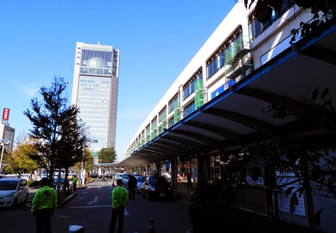
This is actually similar to something I mused about on my post about the point of zoning. Indeed, the value of lots is influenced by how much profit can be made developing it, so allowing higher density developments do increase land value, especially if high density developments is allowed only in a select few areas. This might contribute to the "stonehenge" feel of some areas I saw in Sapporo on my trip there:
"Stonehenge"-style of development in Sapporo, 10+-story towers next to vacant lots and parking lots
He then recommends a dynamic form of height limits, where height is limited not arbitrarily but in relation to the height of adjacent buildings, he suggests 50% higher than the average of the buildings on adjacent lots. Which, again, strangely echoes my own musings about dynamic zoning.

First things first, the good thing about this idea: it supposes that cities must evolve rather than be set in stone and gradually become denser. It also encourages the construction of tight urban fabric and small-scale redevelopment. And it might indeed be sufficient to tame densification in certain sensitive areas to make it more palatable.

However, is it really a good idea everywhere?

Economics of redevelopment

The biggest issue I have with the 50% rule (yes, even if I came up with it myself too) is that if you take an uniform area all with 2-story buildings where demand for housing outstrips supply, 50% increase in density is not going to allow for affordable new units (not unless you can add floors to existing buildings). Each new unit in redeveloped buildings has to incorporate in its price part of the value of the units it replaces.

For example, if a 2-story building is worth 400 000$, a 3-story building built over it will need to incorporate that 400 000$ in its sale value, so if the new building has three units and each of these units cost 150 000$ to build, then they will need to be sold for 290 000$ at a minimum to be profitable, that is nearly twice the cost of building a similar building in a greenfield development. That is a significant barrier to redevelopment.

Curb showing how more expensive redeveloped units are in relation to construction costs and the allowed density increase
But the reality is even worse. In the previous example, I supposed that the current value of houses was equal to their construction cost. That is correct in balanced housing markets where there is plenty of land to develop and supply can organically grow to respond to demand, but in places in high demand where redevelopment is more likely, that's not the case at all, housing is in shortage and its value will therefore likely be higher than the initial construction cost.

Furthermore, if I was correct in my earlier posts and that the ceiling of value of housing in a given area is defined by the marginal cost of building new housing, then that means that if the cost of building new units is much higher than the construction cost of the existing units, then the market value of existing housing will be free to increase up to the cost of building new units, for the economics don't support redevelopment until market value goes over the cost of redevelopment.

What I mean is that if in the uniform 2-story area each unit is worth 150 000$ and building a new unit to the same construction standard in a 3-story building would cost 250 000$... who would actually buy those units when they could have units worth 150 000$ instead? These new units will not move, unless people are willing to pay 250 000$ for them, and if they are, then that means that the value of all the existing units, barring massive flaws and disrepair, would also be 250 000$. In other words, it's only when existing unit prices will be 250 000$ for existing units that it will become worthwhile to build new units...

BUT WAIT! There's more. Since the value of existing units influences the cost of building new units, it means that if current units are worth 250 000$, then the cost to build new units in 3-unit buildings is no longer 250 000$, but rather 315 000$! So now existing units can increase in value to 315 000$ before building a 3-unit building in replacement of a 2-story building becomes worth it... but if that's the case, then the cost of building these new units is now up to 360 000$!

Ouch! I still have good news for you: it converges at one point. At one point the cost of building a new unit does become equal or lesser than the current market value of existing units. At what point?

Here's the graph that shows at what point it happens.
Ratio to construction cost at which point a new unit built in replacement of existing units can cost less to build than current value of existing units (dotted red line is the previous graph)
So for example, if you allow only a 50% density increase (2 to 3 units) and the cost of building each unit is 150 000$, excluding land costs, then the value of existing units can be 3 times as high before it becomes profitable to build new units (ratio of 300%). So units will need to increase in value to 450 000$ before you start seeing some redevelopment that is affordable for the people who could afford to live there at current prices (if you are willing to move upmarket by building luxury units, redevelopment can occur sooner).

Gradualism the like of what was proposed in the Strongtowns article thus has a terrible flaw: it is economically unaffordable. Filtering may help to some extent, with existing units falling in value because newer units are seen as more desirable, so it needs not be that bad, but even then, we are far from affordable housing for all. The economics of redevelopment may make such a rule almost completely ineffectual, unless housing prices are extremely high.


No possibility for higher densities where needed

One of the big problems of such a blanket rule would be that areas can't simply leapfrog the steps of density. For instance, if you have just built rapid transit passing through a low-density area, the rule would allow only for a small increase in density, far less than would actually be required to take full use of the area's opportunity. But you need to be able to concentrate as many stores, jobs and residents near transit stations to make them worthwhile and reduce the need of cars to reach popular destinations.

So to increase density very fast, developers would have to build a taller building, then build an even taller next door and destroy the first building to build an even taller one. Needless to say, that's absurd. I don't believe the idea that buildings should be eternal, I've defended the Japanese way of treating housing as depreciating goods like cars, but even I recognize that you want your housing to stay up at least 20 years, otherwise it's a complete waste.

The Rosslyn-Ballston corridor in Arlington, a Washington DC suburb. The area went from a suburban commercial strip to this after the subway came, it didn't go through progressive 2-,4-,6-story phases to get there. It is one of the rare suburbs in North America where population has increased, jobs have increased and traffic has gone down
The problem of such a rule for transit-oriented developments was brought forth to Charles Marohn by many, including by me. However, it turns out that he didn't see it as a bug in his system, more like a feature. Marohn doesn't believe in TOD, he explicitly said in a discussion:

"I'm not an advocate of TOD but instead DOT, development-oriented transit."

He frequently calls cities building rapid transit lines to areas where the current state of development doesn't justify rapid transit currently a "gamble" with public money and is strictly opposed to it. So if I understand his position correctly, he wants development to first grow to a sufficient density to support rapid transit, then it may be built. So his rule in that approach is not a problem at all, areas where high-quality transit will be built will already have high density, so 50% more of high-density is quite sufficient in his mind.

Now with all due respect, I would ask: how exactly is this "development-oriented transit" any different from what we've been doing for the past 70 years? This is why there was so much dearth of actual transit investments. Rapid transit generally requires more density to be financially viable than car-oriented developments can support. So of course, in an era of car-oriented development, the only areas that got transit were areas built before the car in old streetcar suburbs. So that idea is nothing new and, especially, a sure approach for failure from my point of view.

Not only that, but I think his approach is also a gamble. Because if (despite my predictions) density does get high enough to justify rapid transit, then that rapid transit line will be supremely expensive to build through an high-density area with sky-high land prices. Almost the only way to build a rapid transit through such an area is underground, which costs 200 to 400 million dollars per km.

On the other hand, if you build rapid transit on the surface before the area gets built up too much, then the cost of construction for a line that offers similar speed and level of service is probably around 30 to 50 million dollars per km, almost 8 times cheaper. 8 times cheaper also means that the density level justifying the line is also 8 times smaller. So putting off transit investments is also a gamble, but instead of betting on transit as a major way of getting around, you're instead betting that it will never be justified and that cars will remain the long-distance transport mode forever. If an area grows so much it now requires rapid transit and you have put off investments for years, then you have lost the bet: you thought you could save money by not investing in transit, and you were wrong, now you have to build transit at 2 to 8 times the price of what it could have been if you had invested money earlier, or your city will choke on cars.

The presence of rapid transit stations also give developers a reason to build density around them, when it would be much cheaper for them instead to let old neighborhoods die and to build in greenfield areas where land is cheaper.

For example, the strong regional train system in Japan is no stranger to the fact that all cities develop mainly around their local station. The presence of the station is what draws developments there and it allows people to be free to go to any city without using cars.

Japan's JR rail networks (doesn't include private lines)
Down this street, the Kitami train station, which creates a strong downtown area even in this city of  126 000 people.
In fact, one of the first informations on real estate listings on Japanese websites, after the price and the number of rooms, is how far to the nearest station the unit is. 
Example of apartment listing on Suumo.jp, with information about nearest train stations front and center, this apartment is in Furano, a town of about 25 000 people, far from any big city

Salvaging incrementalism

Still, I think I may understand where Marohn is coming from. An engineering background may explain why both he and I find attractive the idea of simple rules to follow in every situation rather than byzantine arbitrary regulations that carve up cities and countries in tiny pieces where rules vary based on no quantifiable criterion. The kind of absurd situation where one lot may have an height limit of 3 stories when the one next door has an height limit of 2 stories, simply because some planner decided to do it that way without reason way back when and now you need to actively work to change it.

So can incrementalism be saved while taking into account the economics of it and allowing for TOD, bursts of increased density leapfrogging the stages of development, while achieving Marohn's aims to favor the construction of urban fabric rather than stonehenge-style development?

I think so.

The way to do this in my view is that instead of making the height limit dependent on adjacent buildings, it would vary first and foremost by what is present on the lot currently. Meaning that instead of going by the average height of adjacent buildings, you'd use a multiple of the height of the current building, or better yet, by its FAR (floor area ratio: the sum of the area of each floor divided by the lot area). And in order to keep prices from raising too high, going by the second curve I posted, I would recommend an allowance for twice or thrice current FAR, with a preference for thrice.

For vacant lots, buildings should be limited to the average height of current buildings or to 2 stories (or 40% FAR).  This way, keeping a vacant lot would be a waste, because the profit linked to the development of it would be strictly limited to relatively low-density developments, since only developed lots could be transformed into high-density developments.

What would this mean?

Well, let's rake a typical bungalow (all models made in Sweet Home 3D that I've diverted from its true purpose and towards making up different densities and building dense neighborhoods):


This is about 25-30% in FAR, so a 150 square meter (1500 square foot) house on a 600 square meter lot.

If you want to replace this bungalow with higher densities, you could go for row houses...
Three row houses with parking spaces on a driveway, FAR 60-70%
 ...or go the multi-family route with a triplex:
Triplex, FAR 70-80%
If the triplexes and row houses no longer suffice, then they can be converted to 3-story, 12-condo buildings, with a FAR of around 200%.


Later on, you could go even taller if needed.

What of TOD and higher density "bursts" then? Well, you could put a rule saying that any developer that wishes to go beyond thrice the FAR of the actual building to pay a penalty fee equal to the value of the current property times the ratio between the current FAR of the building and the needed FAR it would need to be able to build the future development.

Okay, an example would be better...

Let's say you have a 2-story duplex worth 600 000$ and a developer wants to build a 9-story condo tower in its stead. Normally, with a "3 times FAR" rule, only a 6-story building would be allowed (supposing the same lot coverage). The building on the lot would have needed to have 3-stories for it to be allowed. In other words, the current building should have 50% more stories to allow the 9-story building, so the developer has to pay a development fee of 50% of the current value of the duplex in order to have the permit to build the 9-story condo tower, in this case, that's a 300 000$ development fee.

There, you have an incremental rule that:
  1. Keeps the value of land down for vacant lots to favor development of them
  2. Allows for incremental density in reaction to demand
  3. Makes sure that increased density is sufficient to maintain housing somewhat affordable even when built by replacing existing housing
  4. Allows a way for developers in areas with exploding demand to go beyond the incrementalism when they need to leapfrog the stages of development