When people speak of density with regards to urbanism, most of the time, it is residential density they talk about: how many people live in a city per square kilometer/mile or hectare/acre. However, walkability is usually measured not by how many people reside near you, but by how many services and shops you can access from where you live. So to achieve great walkability, it would seem logical that commercial density is very, very important. After all, if all services and stores in an area are spread far apart, so that you cannot walk from one to another, it's likely the area would be unwalkable, there would be no place to live in where one could access all the services and shops to satisfy their needs. You could live next to a grocery or next to a few restaurants or next to the library, but you couldn't live in a place close to a grocery AND a few restaurants AND the library.
If one looks at old American small towns, in their old areas, the clash between commercial density and residential density can be quite significant.
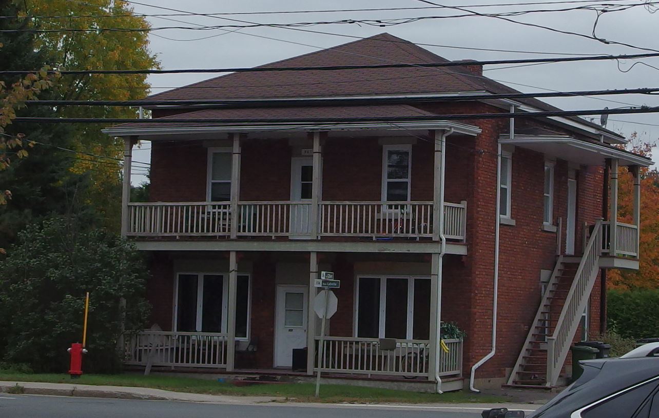
 |
| A traditional American main street, St. Cloud, Minnesota |
Here is the old main street, where old towns concentrated commercial activities. Notice something? Like nearly 100% lot coverage for the commercial buildings? This is not surprising considering that commercial uses have no use for front yards and back yards, and since they are not living spaces, they don't care about keeping the window-to-area ratio low, unlike residential uses where each room needs windows, more or less. So there was no point in wasting space by having courtyards or setbacks. This results in buildings that cover almost their entire lot. Since most of the buildings have 2 to 3 stories, it means a Floor-Area-Ratio of 150 to 250 %! Not too shabby.
Even if only the ground floor is commercial and the upper floors are residential, leading to an L-shaped building as the upper, residential, floors have setbacks due to the need for windows...
 |
| The ground floor has near 100% lot coverage, the upper floors, which are residential, have about 50% due to the need for windows in order to have bedrooms, leading to an L-shape building |
 |
| These buildings are another example, the upper floors are sitting on commercial pedestals that have near 100% lot coverage |
...these buildings still have a commercial FAR of around 90-100%, with an additional 50-100% residential FAR.
But what about the residential areas just a few blocks away? Were they also very dense? Not quite:
 |
| Older residential area near St. Cloud's downtown area, mostly single-family houses with a density of about 10 000 people per square mile (4 000 per square kilometer), so about 40/hectare |
 |
| Another example in the same city, but with a bit more low-rise apartments, resulting in a density of 15 000 to 20 000 people per square mile (6 0000 to 8 000 per square kilometer), about 60 to 80 per hectare |
These areas are made up of detached buildings with large setbacks, the FAR should be around 25 to 50%, but the average seems to be around 30%.
So old American cities had very high commercial densities on main street but relatively low densities in residential areas. And we know these small towns were walkable because they were built in an era where cars were still relatively rare, if not outright in an era where they didn't exist.
Big boxes, mom-'n-pop stores: the logic of commercial uses
I once referred in the past to the self-evident fact that the number of stores that a city could support was dependent on the population and the wealth level, after all, one could hardly imagine 3 huge supermarkets in a village of 100. I mentioned particularly supermarkets, that needed from my estimates 8 000 to 12 000 people to be financially viable. In fact, I checked and there are 37 000 supermarkets in the US, for 315 million people, so around 1 supermarket per 8 500 people. The same is true for other types of stores, with varying "critical mass" of potential customers to be viable: for instance, there are about 2 000 people per convenience store in the US (1 400 in Québec), on the other hand, there is about one Wal-Mart supercenter per 100 000 people. Some stores probably overlap and compete for certain things, for example, a small neighborhood grocery theoretically fulfills the same role as a big supermarket, but can thrive on a smaller consumer base, at the cost of less choice and higher prices for their goods.
So if I can extrapolate from this seemingly self-evident fact that there can be too many stores for a given population, I can make a certain claim: the amount of commercial space in a city is limited by the population that can access it and its wealth level. Basically, there is probably a ratio of how many square feet of commercial area a given population can support. I don't know what that ratio is exactly, I found no study on the matter publicly available online, but the ratio probably fluctuates with certain cultural attitudes and wealth level.
Another thing is that the catchment area of a store depends on the mode of transport. For example, a Wal-Mart cannot survive on walking if there are only 2 000 people within a 10-minute walk of it, it will need to reach out to a bigger consumer base by either being located near a very high-capacity and high-speed transit line (rare in North America, common in Japan) or by offering parking and being located near high-speed roads so as to allow consumers to reach it.
What that means is that in the era in which small American towns were built, as travel speeds were quite low, commercial needs of the population had to be satisfied locally. Going to the next town over could take a few hours. That meant that the bigger the city, the more well-furbished and specialized stores could be found and accessible, while small towns had to deal with a dearth of commercial use, maybe just a general store where many things had to be ordered in advance. The usefulness of the Sears catalog is self-evident in such a context: allowing small towns to shop the products of a big department store that only large cities could otherwise support. Nowadays, with cars being so widespread, residents are no longer restricted only to their town's commercial offering but can access the entire region's offerings, putting old small stores at the center of urban areas in competition with big box stores located near high-speed roads.
A modelized thought experiment
OK, so I'm going to do a simplified model to explore the issue, inspired a bit by my exercise comparing uniform versus concentrated density. I'm going to suppose:
1- Uniform residential and commercial density
2- All commercial uses are at the center of the town (or neighborhood)
3- The ratio of commercial to residential floor space is 1 to 10, so for each 10 square meters of residential floor area, there is 1 square meter of commercial floor area (this is not based on any calculation of mine, just a random number)
4- Distance is measured as the bird flies rather than Manhattan distance, because it simplifies things.
The idea of all commercial uses being in one spot is a simplification, in reality, a few proximity stores will be distributed around the city, but I keep that assumption because commercial uses do tend to concentrate in one spot, especially specialized stores, and I want to look at people's ability to walk to all commercial uses, not just to the nearest one. I will look at 4 scenarios to see how residential and commercial density play a role:
 |
| Scenario 1 is a traditional North American town with a dense downtown and a relatively small population (10 000) Scenario 2 is a 20 000-people city with a typical sprawl-type commercial area in the center (low density commercial) |
 |
| Scenario 3 is the opposite of scenario 2: the commercial center is still dense, but residential density is reduced by 33%. Scenario 4 is what is often seen, with low-density commercial areas largely located on the periphery |
Scenario 1 is just a reference, it is a traditional small North American town, with relatively low residential density (30% FAR) but commercial uses concentrated in a small area downtown at decent density (100% FAR).
Scenario 2 is a scenario where the small town has grown to 20 000 people, allowing for a more diversified commercial choice. However, there are two main differences:
1- Segregated uses: there is no residential upper stories in the commercial downtown
2- Low-density commercial developments that reflect typical strip mall commercial developments with commercial areas surrounded by huge parking lots
 |
| A South Burlington, VT mall (thanks to Bill Morris in the comments for pointing out it's not actually in Burlington)... |
 |
| ...which has 8 600 square meters of floor area on a lot of 41 000 square meters, for a FAR of roughly 20% |
 |
| Levittown, NY is a good example of that design, however the commercial area is not radial but linear |
Comparing Scenario 2 to Scenario 3 should demonstrate the relative importance of commercial vs residential density.
Finally, Scenario 4 is a much too frequent example of a small town which traditional downtown has been converted to strip malls (20% FAR commercial), but it has not been allowed to increase in size, so the downtown only has one fifth of the commercial uses it could hold before. The rest of the commercial buildings have instead been built at the periphery, near a theoretical highway, because that was the only place available for it. So we have a commercial area at the periphery, with a small commercial node at the center of the town.
Analysis
Distance to center of commercial area
In the first approach, I will simply look at the distribution of the population depending on the distance to the middle of the commercial area, as I did earlier.
 Now here are some specific data points, namely an estimate of a probability of walking to the center of the area (based on a personal estimate of probability of walking relative to distance), a share of population living within 600 meters (10 minutes walking distance) of that center and the median distance.

So the old American town is a very walkable town, with most people living within 10 minutes of the downtown area, but with only 10 000 people, the commercial area will not offer a lot of variety and choice. This is a town of small stores with relatively high prices and poor product selection.
Scenario 4 shows how the habit of building low-density commercial areas on the periphery by lack of space zoned commercial in the city is disastrous. There's very, very few people who live within walking distance of the commercial zone's center.
Scenarios 2 and 3 are the most interesting results. Here, we can see that though scenario 3 has a lower residential density and the median distance to the center is higher than Scenario 2, it still remains that significantly more people are within walking distance of the commercial zone. This makes sense as a more compact commercial zone allows the residential zone to begin much closer to the center. It's important to remember that walkability is a very, very local matter.
So here are the results with an analysis focused on the furthest commercial use:


The traditional small town is still exemplary, but the small advantage of the scenario with a compact commercial zone but lower residential density (scenario 3) over that of the scenario with traditional residential density but a low density commercial zone (scenario 2) has become much more significant. Nearly 10% of the population in scenario 3 lives within very walkable distance from all commercial uses, but 0% do in scenario 2 (normal, as the commercial zone itself has a diameter of over 600 meters).
Note also that in reality, the patterns today are often more linear than radial, which makes things even worse for walkability. Also, that people may demand access to certain commercial uses that a 20 000-people city or neighborhood cannot support on its own (major mall, Wal-Marts or the like), which increases the need for proper transit so these uses can still be accessed without cars.
A city is first and foremost about economic activities, not houses. And so, the density of economic activities is crucial, perhaps even more crucial to walkable, transit-friendly urbanism than dense residential areas. Building dense residential areas in a city where economic activities are spread apart may make the city more financially sustainable by providing a greater tax base for a given infrastructure, but it will not reduce car-dependency much, if at all.
Currently, commercial areas tend to be both extremely low-density and far from residential areas...
...both of these need to be reversed. Discussions about the proper form of residential areas, though fascinating and very relevant, will stay quite secondary if we cannot get commercial area in an urban form. Indeed, while playing around with the inputs on my Excel models of the "commercial on periphery" model, even if I increase the average residential density to 200% FAR (which is the equivalent of a typical Euro-bloc with 3 or 4 stories), the area remains unwalkable with only 10% living within 10-minutes walking distance from the center of the commercial area, and no one living within walking distance of all commercial uses.
With a dense commercial core which is eminently walkable by itself, transit can become quite efficient as people living too far from it to walk only need to go there by transit once, when they get down from the stop or station, they have access to everything, needing transit only to go back home once they have finished their activities for the day.


So the old American town is a very walkable town, with most people living within 10 minutes of the downtown area, but with only 10 000 people, the commercial area will not offer a lot of variety and choice. This is a town of small stores with relatively high prices and poor product selection.
Scenario 4 shows how the habit of building low-density commercial areas on the periphery by lack of space zoned commercial in the city is disastrous. There's very, very few people who live within walking distance of the commercial zone's center.
Scenarios 2 and 3 are the most interesting results. Here, we can see that though scenario 3 has a lower residential density and the median distance to the center is higher than Scenario 2, it still remains that significantly more people are within walking distance of the commercial zone. This makes sense as a more compact commercial zone allows the residential zone to begin much closer to the center. It's important to remember that walkability is a very, very local matter.
Distance to farthest commercial use
This is a variant of the first analysis. Instead of looking at the distance to an arbitrary center of the commercial zone, I look at the distance to the farthest commercial use, basically the opposite side of the commercial zone. This is an interesting data because it shows how much any one person can walk to the ENTIRETY of the commercial offerings rather than to a "center" where there might be nothing at all. |
| The center (red dot) of this commercial zone is not actually close to any commercial building except a small fast-food restaurant, every commercial building is 1,5 to 2 minutes away on foot. |


The traditional small town is still exemplary, but the small advantage of the scenario with a compact commercial zone but lower residential density (scenario 3) over that of the scenario with traditional residential density but a low density commercial zone (scenario 2) has become much more significant. Nearly 10% of the population in scenario 3 lives within very walkable distance from all commercial uses, but 0% do in scenario 2 (normal, as the commercial zone itself has a diameter of over 600 meters).
Note also that in reality, the patterns today are often more linear than radial, which makes things even worse for walkability. Also, that people may demand access to certain commercial uses that a 20 000-people city or neighborhood cannot support on its own (major mall, Wal-Marts or the like), which increases the need for proper transit so these uses can still be accessed without cars.
Conclusion
At least in the case of our recent development patterns, it would seem that achieving commercial density is far more important to re-establishing walkable cities than densifying residential areas. Concentrating commercial uses and economic activities creates an area where residents can access most economic activities on foot. Even if there are few people residing there currently, this is still an opportunity for redevelopment to bring people there, a way to urbanise a city or a neighborhood without even needing to affect any residential area beyond the walkable distance of the commercial core. |
| The Rosslyn-Ballston corridor in Arlington, VA is a rare successful example of a suburb that has been successfully urbanised in North America, yet all the urbanisation has been concentrated in a corridor about 500 meters wide, beyond that, areas remain suburban |
Currently, commercial areas tend to be both extremely low-density and far from residential areas...
 |
| Above, a map of residential density of Levittown, NY, below, the WalkScore map of the same area, note how the highly walkable areas have no people in them, almost like a mirror image, due to use separation |
With a dense commercial core which is eminently walkable by itself, transit can become quite efficient as people living too far from it to walk only need to go there by transit once, when they get down from the stop or station, they have access to everything, needing transit only to go back home once they have finished their activities for the day.