Friday, August 29, 2014

My take on how transit should be planned

In general in North America,there is largely two cases determining when rapid transit investments are done

1- In places that are already pretty dense and where demand for transit is so high that it overwhelms the local transit lines. Rapid transit here serves to increase the capacity and quality of transit where transit is already highly justified.

2- In places where there are chokepoints (often natural due to large rivers splitting an urban area in many parts) that make increasing road capacity outrageously expensive, then rapid transit is used to support the downtown area by increasing the capacity of transport links without having to build new roads or widen existing ones.

In terms of what form they will take, in the first case it usually takes the form of subways built to serve old streetcar suburbs which already have high density and not that many parking spots. The second will usually be commuter rail or light rail lines extending far beyond the city core, often with stations surrounded by huge expanses of parking, so that residents of low-density neighborhoods can park at the station then ride the rest of the way. In order to save on the capital costs, they will often use existing rail lines or be built in a freeway alignment.

Subway station Mont-Royal in Montréal, in an old streetcar suburb
Blainville station on a commuter rail line in Montréal, notice the parking next to the station, the lack of buildings around it and the housing around that are low-density single-family detached homes

 What is the problem?

The problem is that this way of planning transit is merely reactive, reacting to development patterns. In terms of direct ridership potential, the first approach is certainly the better, yet it is available in only a few areas, essentially older, denser neighborhoods with mixed uses. The latter is cheaper but has low potential for ridership, at least as things stand. Both approaches ignore the very significant influence that the presence of a rapid transit line can have on developments. Sure, transit-oriented developments can follow, but it's often an uphill battle.

The point that is important to understand is that high-capacity rapid transit is not only a transport tool, it is a powerful land use tool which task can be to shape cities and their development pattern.

The problem is that as we use highways to tie in cities together, development flows along on highways and other roads, the resulting development is then of course car-oriented because only cars are viable transport modes when areas develop. Later on, we try to add transit to it, but areas built for cars tend to have low density and to spread apart destinations rather than concentrating them, so car-oriented suburbs will not offer a lot of potential for transit.

So how can we convert our cities to make them transit-friendly? By changing them. When a rapid transit line comes in an area, there must be an understanding that the area within 800 - 1 000 meters (half a mile) of the stations WILL change and densify significantly. The area around must be replaced, what was adequate for car-dependent sprawl will not be adequate once there is a subway station. This is where euclidean zoning hurts the most as it is extremely hard to change, so does the idea that once an area is built, it should NEVER change, which is unfortunately too common both on the right and on the left.

The ridership gain potential from transit investment is mostly dependent on how much development transit can attract, not by convincing people who used to drive to take transit.

I spoke of streetcar suburbs recently, and the point that is most important to understand is that the transit line was built BEFORE the suburbs were built. That is why streetcar suburbs are such good TOD, it's because there was a transit line when the area was developed, so developments took the transit line in consideration. Just like right now industrial parks and malls are built around highway interchanges, at the time, industries and businesses flocked to the streetcar line, so as to be easy to access.

One thing that could be done is to simply build rapid transit prior to developments. People often think rapid transit is very expensive to build, but that's not really the case. Overall, rapid transit is less expensive than highways to build, laying tracks is no harder than building an highway. If subways are so expensive, it's largely because they are generally built underground (which is very expensive) and only in areas that are mostly all built-out already, which makes surface lines hard and expensive to build. You could theoretically use eminent domain to carve a narrow corridor through inhabited areas for the purpose of building rail through, but that would be quite hard to do politically, and still pretty expensive.

Example: Munich's S-bahns

Munich, like many other German cities, has an extremely well-developed transit network. One of the most interesting aspects of it is the S-bahn network. S-bahn are essentially light-rail lines that run on grade-separated tracks outside cities and on streets in the city. In France, they would be called "tram-trains".

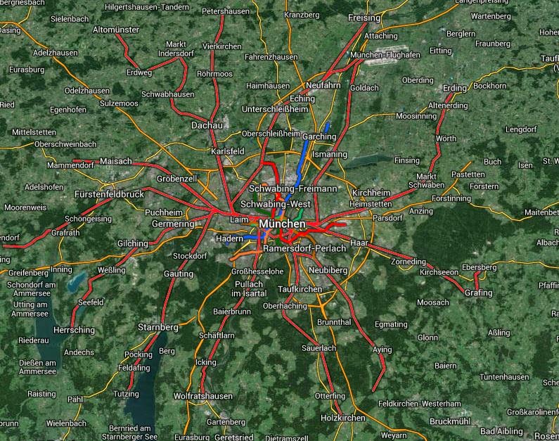
The spiderweb of red lines on this map of Munich are the S-bahn lines
As you can see from the previous image, the S-bahn lines go far into the suburbs and connect them to the central city. The diameter of this web is around 70 kilometers, around 45 miles. That is nearly twice the diameter of the area covered by the New York subway. The system has about 445 kilometers of lines in total, about 280 miles, which is more than the 337 kilometers of lines of the New York subway (around 200 miles), for a population that is 6 times less (10 times less if you count the entire metropolitan areas of both). And this doesn't include the subway, because Munich has subways too, and some regional train lines. Of course, the lines don't have the same capacity as the New York subway, but they do offer quite similar service in terms of speed and comfort for users.
The dark green line is the S-bahn, the S symbols are the stations
In this image, we can see small suburbs of Munich, with an highway on the bottom of the image and the S-bahn going through the center of these towns. Often, shopping streets will be within walking distance of the S-bahn stations rather than being malls next to the highway.

How can Munich afford this? The S-bahn lines run on the surface in the suburbs, which makes them especially cheap to build, no more expensive than the highways and major roads on which North American suburbs depend. Their presence in growing suburbs attract developments near them, which feeds the system well.

Other example: Chigasaki

Here is another example of a surface line attracting developments, a Tokyo suburb this time, Chigasaki station, on the Tokaido line. The Tokaido line is actually a regional train line 714-kilometer long (443 miles), but it doubles as commuter rail as it is just as easy taking the Tokaido line as taking a subway line. No need to buy a ticket beforehand for a given departure time and hand it to a staff member prior to boarding (like Amtrak and Via Rail do, imitating airlines... because when thinking about user experience, airlines are the best example that came to their minds apparently!).

Anyway, here is what Chigasaki's train station looks like:
Chigasaki station
The station is the huge white building in the background. Why is it so big? Because it includes many stores inside it. The letters in blue spell out "Lusca", which appears to be the name of a company making shopping centers if I understand correctly. There is a pedestrian plaza built over the street on huge walkways, which I have also seen in other places like Sendai. This frees up the ground area for a bus terminal and taxi parking, as you can see plenty of buses in the lower right corner of the image.

You can also notice plenty of tall buildings around the station, these are also stores and restaurants, and some offices, all concentrated around the station.

Street that leads to Chigasaki station
Just like I did for the Plateau, let me show you the results of a search for "mise" (store) on Google Maps around Chigasaki station.
Locations of stores in Chigasaki
Note how the stores are massively concentrated around the station and the streets leading to it. This is supremely convenient for transit users, when they arrive at the station in the morning and they want a coffee, there are plenty of restaurants to choose from on the way to the station. When they come back home in the evening and they have to buy a few groceries, they can easily do so, it's on their way. That's how it works too in freeway-oriented developments, stores flock to freeway exits to be "on the way" of commuters taking the freeway or getting off of it.

Here is an example of some of the streets leading to the station, the smaller ones in particular.

Shopping street near Chigasaki station
What about housing? Well, there is high-density housing, but overall, priority is given to businesses, not housing.
South side of Chigasaki station, some tall residential towers with shops on the ground floor
Here are three pictures of a street near the station and how it changes as one walks further away. First, right next to the station, there are shops...
 ...then, you come to residential towers of some height...
...and finally, on the side streets, you have single-family housing.
All of this within walking distance of the station.

This is what TODs look like, proper TODs. Though not every station is built the same way, each 2 or 3 stations, you will come over something like this in Tokyo's suburbs. So when building transit stations in built out areas, it is important to allow developments that look a bit like this. And it's important to include not just proximity stores like corner stores, but to have specialized stores in malls or big shopping areas once in a while around stations, attracting big brands if possible. That way, people living near the line may be tempted to use it to go shopping rather than just going to work, they're no longer forced to go to big malls on the outskirts for their specialized shopping.

I think too often even people who are generally allies of urbanism shirk at allowing this kind of development, they seek to preserve "character" and "mom and pop stores" by keeping big stores away from neighborhoods. But this is counter-productive, because by keeping the big stores from settling near transit, they just move to the suburbs, and then a lot of people start taking cars to them.

In conclusion

Transit is not merely about transport, it is about shaping cities and influencing their development, especially high-capacity, high-speed transit.

Rapid transit investments need to be accompanied by significant relaxation of zoning so as to allow development to flood the transit stations. A new transit station must not merely be an added bonus for current residents who happen to live near, it must herald major changes and increased density, else, the money is almost wasted. Increase in ridership will come when people and businesses move to the area, not when previous residents living in car-oriented development start to abandon their cars to take transit.

In fact, if you feel daring, using eminent domain to appropriate low-density areas before the line is built, then re-selling the land after to developers may well serve to pay part of the line's construction. This is called "value capture". There are other ways of doing it, like special local taxes on properties that see their values increase, but these taxes often have a counter-productive effect of discouraging development in areas subjected to this extra "value capture" tax.

It is best also to plan for transit BEFORE areas are built out and to extend rapid transit lines to the suburbs as quickly as possible, as building tracks in undeveloped areas is no more expensive than building roads there. It is easier to influence the built form of an area when it is being built than to transform a fully developed area, and the housing in greenfield developments tends to be cheaper than in infill developments.

Sunday, August 24, 2014

What is zoning good for?

I've been extremely critical of zoning in my posts, so at one point, I had to ask myself: zoning, what is it good for? (no, the answer I've come up with isn't "absolutely nothing!")

This is a reflection on zoning from the ground up meant to provide for a coherent understanding of zoning, what it does and does not, what worthwhile objectives, if any, zoning might have that justify it.

First, what zoning isn't

Often, zoning is portrayed as something necessary to provide the adequation between the different needs of communities, places to live, places to work, places to provide goods and services, etc... So zoning supposedly could make sure that cities are better built. When pointing out how many zoned cities are anything but that, that they tend to be massively unbalanced cities with huge single-use zones, some will say that it's simply the planning authority being incompetent.

The reality, I think, is pretty obvious, zoning has nothing to do with trying to build an efficient city. I mean, you can try to do it, and if you go for strict zoning, you should definitely try to do it. But still, zoning is not a positive tool but a negative one. By that, I mean that it's not because you zone someplace for a certain type of development that it will happen.

Zoning isn't about telling what will be built in a place, it is about forbidding any different type of development from happening in that place. When you zone an area to be residential, you're not really saying "residential developments will occur here", maybe they will never come, what you're really saying is "all developments apart from residential developments are banned here".

Furthermore, in relation to economic efficiency and to cities' needs, since zoning can ever but ban uses, by default it would mean that zoning reduces efficiency and reduces a city's adequation of its many needs.

Why is that?

Banning inefficient uses of space has little to no effect as they tend to be weeded out naturally, bans are only ever meaningful against EFFICIENT uses.

Let's make an analogy, let's say you are a dictator and saw someone walking on his hands for a few steps on a sidewalk and you thought: "What an inefficient and uncomfortable way to get around!". Then you decide, "I know! I will ban people from walking on their hands on sidewalks, so no one does this inefficient, useless thing!". You pass a law forbidding people from walking on their hands on sidewalks, it's now illegal... but who is going to be affected by this? Everyone knows that walking on one's hands is a stupid way to get around, that's why no one does it.

So you don't need to ban it, people won't do it anyway, maybe a few people for fun will try it once in a blue moon. So how effective is the ban? Utterly ineffective, you'd waste more resources enforcing the ban than you'd save society by banning this inefficient practice.

But if you were an insane dictator, you saw the same thing and thought "If everyone walked on their hands, they wouldn't need to wear shoes and socks, and their feet wouldn't stink anymore, BRILLIANT!!!" and passed a law forcing everyone walking outside to walk on their hands, that law would change things a lot. It would make things a whole lot worse, because people's first desire of doing the smart thing and walking on their feet would be banned. But the resulting situation would be utterly inefficient and a terrible waste of time.

It's the same thing with zoning. For instance, if you have a transit station with vacant lots around ready for residential development, you don't really need to zone the area for high-density housing, because high-density housing generates a lot more revenue per square foot of land than low-density housing. So if there is a 600 square meter lot (6 000 square feet), that a multi-family developer could build 8 units on it for a total of 400 000$ in profit while a single-family developer could build a single McMansion on it for 150 000$ profit, the first developer will be willing to pay the land far more than the second one. If the land is sold for 200 000$ after bidding, the first developer could still buy it and make 200 000$ on the lot, while the latter would lose money if he bought it for his McMansion.

So in that case, zoning the area for high-density residential developments and banning low-density housing is absolutely meaningless. If you didn't zone anything and let people do whatever they wanted, the high-density housing would still win out. Zoning only has an impact if you do the opposite and ban high-density developments, then, deprived of the more efficient and profitable avenue for development, the land will likely be cheaper, cheap enough to allow the McMansion to be built at a profit.

Even in built-out areas, zoning has the effect of preventing efficient use of space and buildings. If some place lacks a corner store but has too many houses, it is possible that someone would buy a house and turn it into a corner store, if it is more efficient than just another house. But not if zoning bans it.

Zoning's achilles heel: hard to change to fit an evolving city

The biggest problem with zoning in terms of efficiency is that it doesn't allow for easy tweaking or changing urban fabric. Zoning sets in stone a decision made at one point in time, at that moment, it may have seemed the proper use of the land, and it may well have been. But mankind advances through trial and error (even the so-called "wisdom of the market" is merely trial and error and the application of the simple truth that "what cannot go on forever must eventually come to an end"), so when an error is made, or when context evolves, how easy is it for the mistake to be corrected?

Without zoning, or with lax zoning, it can be corrected very quickly. A promoter may smell an opportunity from an area marred with bankruptcies or low value and sweep in to provide for what he believes is better suited to the needs of the neighborhood, which will yield him a better profit margin. But zoning doesn't allow that, not without first modifying zoning, which is notoriously hard to do for many reasons, and if the zoning was made too recently, it may also run against the ego of the local planner. Many people in authority have trouble ever admitting they were wrong, changing zoning made less than 10 years ago, or even 20 years ago, is like telling the planner or the planning office that they screwed up. It doesn't help that people get ahead thanks to their reputation, publicly admitting they have been wrong, though a sign of humility and competence, may instead taint a professional reputation.

So even zoning that is well-made for economic efficiency faces problems in the future by making it much harder to change course to fit evolving situations. What might have been efficient when the zoning was made may no longer be efficient 20 years afterwards. One example of that is subway stations that were built in built-up areas subjected to zoning. Often, even 20, 30 years after the subway station has come, the area still remains 80-90+% the same as when the station was built, even if the station could support much higher density housing, or large-scale commercial developments or offices.

For instance, here is Station Sauvé, a subway station in Montréal, that opened in 1966, nearly 50 years ago, as seen from the sky:
Station Sauvé, seen from the sky
Rue Berri, right next to the station
The area is notably low density, with graveyards around the station and single-family houses that have stood for decades. Despite nearly 50 years of presence of the subway station. no high-rise residential housing has sprouted, no office building or commercial area has been built. Zoning keeps the area frozen, as if the subway station had never happened. Prior to the subway station, it may have been an efficient use of space as the area is pretty far from downtown, but nowadays, the area is severely under-used, and it's not the only station in that situation. Montréal's metro is one of the most used in North America per capita, but it has almost nothing to do with TOD, as little to no TOD has actually occurred, and all with the really dense streetcar suburbs it has been built in, and the strong downtown.

If zoning is maintained, it's clear to me that it needs to be dynamic, to change as the area changes, rather than static and set in stone until efforts are undertaken to change it. I've already written about how this could work in another article.

So, zoning only leads to inefficiency, is it completely useless?

If the only thing that mattered was economic efficiency, zoning would likely be completely useless, all that planning would actually involve would be providing public infrastructure to orient development. For instance, providing wider streets to attract businesses and offices alongside it, building transit lines to attract density around them, etc... People who would try to build any development attracting or generating a lot of trips in an area devoid of proper transport infrastructure for it would shoot themselves in the foot and so they wouldn't do that.

However, there are other things than economic efficiency in life. For one thing, there is the issue of externalities, impacts of an economic transaction or decision that affect people other than those directly involved in it. For instance, building an heavy industry factory near to housing is actually economically efficient for the owners of that factory and for employees as it reduces transport distances and increase the pool of people they can employ, but heavy industry brings along a lot of truck traffic, of noise and air pollution. So it impacts the entire residential area. In this case, what is economically efficient for the economic actors isn't actually what we would consider socially optimal.

We could also point out certain land uses which don't really contribute to economic activities, or at least not so much as to be profitable. For instance, parks, especially neighborhood parks, could rarely be profitable on their own, yet still serve to increase the quality of life of people. Even private parks in the past generally only survived through the support of rich private supporters who would subsidize them in a way, putting money in them with no expectation of direct returns on that money. However, such problems can be solved by governments merely using public money to buy land and run it. You don't need to zone land for parks if you simply allow government to buy land directly and hold it as a park.

So the main justification of zoning is the control of externalities. Some may think that even this is going too far, that the courts could serve to control externalities by allowing individuals to sue others for nuisance caused by their use of their own land. I personally am not convinced, especially as courts are extremely expensive to resort to, so leaving it to the courts would mean the rich could protect their quality of lives easily, the poor... would be forced to take it and stay silent. At least zoning has the advantage of protecting, theoretically, the poor and the rich in equal measure. Working through courts is also a reactive process, nuisance becomes visible in many cases only after it has occurred, forbidding someone from building a factory in a residential neighborhood is one thing, letting someone build that factory then shutting it down for "nuisance" is quite another.

The issue of "externalities" can also be quite large. The issue of air pollution, noise and smells is a very easy one, the nuisance is quite evident. But what about the person arguing that a taller building is blocking his access to the sun?
Equitable building in New York, the height of it and lack of setback prompted the city to adopt regulations to limit building height to protect access to the sun, source of the image
Or that a "pop-out" building is breaking uniformity and making the area uglier, at least as some people see it?
A "pop-out" townhouse some wish to ban in Washington DC
Or that a building is made from a façade of unusual material or colors, again making the area uglier according to many?
The so-called "ugliest house in Queens" has many neighbors seething with rage
In all these cases, certain zoning codes have regulated buildings to placate people opposed to such buildings, with height limits and control of materials on the façade of buildings.

Where do we draw the line? It's clear that more than just direct nuisance, zoning may be a way to tackle certain issues to preserve certain social objectives deemed worthy by the local community, even mere aesthetic objectives.

So, to sum up, zoning exists mainly to sacrifice economic efficiency for the sake of reducing externalities and to preserve certain social objectives seen as desirable by planning authorities and the public at large. Which places us in an ambiguous position, how much economic efficiency are you willing to sacrifice for social goals? Is it okay to limit height for instance in order to keep an uniform street front, with buildings all of the same height? Is it okay to keep buildings far from the streets to preserve an uniform building line?

Many of these objectives are also often locally desired, but not desired by society at large. For example, much of America's zoning in suburbs and small towns was designed with the goal of "keeping the ni**ers away". Much of residential zoning in North America is even now based on the goal of socio-economic segregation, to keep poor with poor, middle-class with middle-class, rich with rich, by keeping the housing types each group desires (or can afford) separated in their own neighborhoods.

The current status quo is often an extremist approach which throws economic efficiency out of the window and gives priority to local social objectives of maintaining "harmony", uniformity and socio-economic segregation, keeping neighborhoods "as is" and preventing change. It's clear that it doesn't work. If there is a proper balance between economic efficiency and externalities/social objectives, that balance can vary from person to person. One interesting approach is a mainly form-based zoning code, which doesn't control uses much but mandates certain building forms like height controls, setbacks and the like to preserve uniformity and avoid neighbors clashing over "ugly houses". This keeps some flexibility with regards to land use to be more economically efficient, an objective that is often ignored by traditional euclidean zoning.

Limiting land value: could it be worthwhile?

One of the impacts of zoning that restricts density and uses is to limit land value, at least until an area gets built out and a land shortage occurs. For instance, to return to the example of the condos versus the single-family house, if condo-builders might accept a 200 000 $ lot but the house-builder only tolerates a 100 000$ lot, if you can build both on every lot, the result may be that all lot owners will demand 200 000$ for their lots as it's what they see others like them get for their lots. The impact would be to price out houses from the area if lot owners are willing to sit on their property long enough to get it, or at least houses would have to be smaller on smaller lots or be more expensive. But if zoning intervened and banned condos, then as the amount of money people are willing to pay for lots come down, the land value would also fall.

So land value, absent shortage, is often dependent on how much profit can be expected from the development of it. The result is that on land where high-density development is allowed and viable, land value is likely to be very high as lot owners would price their land for this kind of development. It may actually cause problems when developing certain TODs. I've heard that this has been hurting Houston in its quest to build TOD around LRT stations, lot owners price their lots for high-rises, but much of the areas around LRT stations are currently parking wastelands with little to no urban fabric.
Bell station in Houston, 1 kilometer from downtown, surrounded by a wasteland of asphalt and parking
What Houston needs here is to fill up the area quickly, high-rises can wait, they could build thousands of housing units and hundreds of shops around their LRT lines all with low-rise buildings, or even mid-rise buildings, filling up the area, building an urban fabric much faster than they're doing now. Zoning here could perhaps be useful to keep land prices down and allow the area to build up much faster, with density limits being relaxed over time as the area gets built up.

One alternative to that is the land value tax proposal, where property taxes are reduced while the tax rate on land value is significantly increased, making speculation on land much more expensive and prodding land owners to sell their land much faster.

Conclusion

Though zoning has its uses to deal with externalities and to preserve certain social objectives, it is crucial to understand that, by definition, zoning hurts the efficiency of urban areas, notably by increasing distances to travel and making car use necessary rather than optional. Indeed, zoning can only effectively ban efficient uses of land, inefficient uses of land tend to be weeded out naturally because they don't tolerate high land value. So even if we accept some zoning, we have to be mindful of this effect and to consider whether the trade off is worth it.

Currently, we are going much too far with zoning, to avoid any friction, we gladly sacrifice economic efficiency totally and preserve areas in formaldehyde. We need to understand the costs of the way we are doing things and to revisit the way we regulate our cities from the ground up if we want to build better, more sustainable and economically dynamic cities.

Monday, August 18, 2014

Houses: investments or depreciating goods?

In North America, one frequent advice people receive is not to rent, because that money is lost, whereas owning a house is an investment that will not be lost. To an extreme, some people even bought houses or condos just for investment purposes, something that contributed largely to the housing bubble in the United States a few years back. But even with the bursting of the housing bubble, people still claim that houses are good investment prospects.

However, there is a counter-example to the idea that houses always appreciate: Japan.

In Japan, house-building is completely different. In North America, most houses are built by companies at one time when they build an entire subdivision, then sell the houses to people. In Japan, many if not most houses are built by people actually buying or renting a lot, then hiring a construction company to build their house for them. This is possible largely because Japanese planning is much friendlier to piecemeal constructions than in America or Europe.

But the main difference is what happens to house prices. They drop over the years, pretty fast even, and most people accept that the house they build will not be worth much in 20 or 30 years. In some cases, the house's value is even negative, people will offer buyers to destroy the house for them, at a price.

How can we reconcile these two attitudes on an economic point of view?

Now, it's true that a good's value ultimately is whatever people are ready to pay for it. But in the long run, prices tend to have rational explanations. For example, in determining the cost of a house near a vacant lot, the value of that house ultimately will depend on the cost of building a similar house on the vacant lot next door. If the seller demands more money than the cost of acquiring the land and building a similar house, then people will opt for that instead of buying the current house. Is it possible that both the North American and Japanese approach may exist in fact in the same economic reality?

Price of house vs price of land

First things first, my understanding of house prices is that they are actually the sum of two things:

1- The price of the building itself
2- The price of the land

I think essentially the only reason why house prices tend to appreciate over the years is not the price of the building, but the price of the land. Unlike houses, you cannot build land, land is a fixed supply. So when an area is desirable and you have run out of land to build on, the land becomes rare, and so it becomes more expensive. Even in sprawl, this has an effect, all inner suburbs were once outer suburbs, so as sprawl extends, unbuilt areas nearest to the downtown area become rarer until they essentially disappear. So the only land available to purchase is the land that comes with houses already built on them as some people move away and have to sell their homes. This creates a shortage of land and drives the land prices up. Unless you make old neighborhoods so undesirable that people no longer want to live there in general, which typically occurs when people put freeways in old neighborhoods, cutting off  the community from itself and from the neighboring area.

Speculation, which creates an artificial shortage of land as speculators hold them to push their prices up, may also have the same result on land prices even when there are unbuilt areas around.

So the reality is that the small Vancouver house worth 1 million dollars isn't worth it due to the house itself, but due to the land it's sitting on, which is highly desirable. If you offered to sell the house for 1 million dollars, but once the sale is done, you removed the house to a location of the buyer's choice and kept the land, no one would take you up on your offer. The house itself is likely only worth 100 000 or 150 000$, which is the replacement cost of the structure.

This effect can be compensated by higher density, which zoning often bans, condemning desirable areas to housing shortages. But even if you allow density, the higher density allowed still means that land prices are likely to have higher value per square foot of land... higher density just dilutes this higher land cost through many units, retaining housing affordability.

Buildings' value naturally depreciates

Contrary to popular opinion, I don't think houses actually appreciate. They are not special. In life, most durable goods depreciate as time take its toll on them. That's true of everything, like roads, railroad tracks, vehicles, etc... But that doesn't mean that value always ends up at zero, no, the value of many of these goods gets reinforced by more spending on them. We fix roads, replace railroad ties, repair cars, etc... This money is injected into these durable goods to maintain their quality or sometimes even to improve them and increase their value.

It's basic accounting. When you buy a durable good, you don't lose the money, you simply transfer the value from a liquid good (money) to an immobile asset (house in this case). Over the years, the asset can either appreciate or depreciate, and any injection of funds to repair it or make it better results in an increase in the value of that good.

So if you have an house that is worth 200 000$ and build an extension for 30 000$, then your house, according to accounting practices, should be now worth 230 000$.

So let's take an example of an house bought for 250 000$, 200 000$ for the house itself, 50 000$ for the land. The owner pays 2 000$ per year on average on various maintenance and repairs, which helps maintain the house's value, and spends 15 000$ every 10 years as a big project (kitchen remodeling, adding a pool, building a concrete porch in the backyard, etc...). In the meanwhile, the house itself depreciates at 3% every year while the land appreciates by 3% every years as the area gets built up and land becomes rarer and rarer. I suppose 0% inflation.

Here is what the house value looks like according to a standard accounting model:
House value
 Here is what the land value looks like:
Land value
 And finally, the sum of these two values:
Total value over time
Overall, there has been an appreciation, but all of it comes from the land. The house value, despite significant improvements, has still fallen over the years. The total cost, house and land, was 250 000$ and the final value was about 275 000$, a gain of 25 000$. However, over the years, the home owner spent an additional 105 000$ on maintenance and improvements, for a real total cost of 355 000$, and a loss of 80 000$.

For example, I'll take my parents' house. Bought in 1978 for 75 000$ (around 250 000$ in 2014 money), it used to have an unfinished basement, a small balcony in wood in the backyard and no pool. Over the years, my parents spent tens of thousands of dollars having the basement finished, having an in-ground pool dug and built, remodeling the kitchen and toilets and replacing the backyard balcony with a large concrete porch, I'm not talking of the regular maintenance here. Overall, my mother told me they have put about 150 000$ in various renovations. The house is now evaluated at around 350 000$, which is less than the sum of the initial price and all the money put into renovations, once adjusted for inflation.

Another empirical proof of this is that new buildings in expensive areas tend to be more expensive than old buildings, all else being equal. Having a new home over an old one tends to be viewed as a good thing, the new one will be more modern and have more amenities and will be less likely to require repairs in the next few years. An old high class building can still be worth more than a recent shoddy construction, but that's an exception, not the rule, and a new high class building would probably be more expensive.

The Japanese attitude on the other hand is to initially build the house you want, then do the minimal upkeep, without remodeling and renovating the house significantly. So let's simulate what this looks like, same 3% depreciation for the house and 3% appreciation for the land, same 200 000$ value for the house and 50 000$ value for the land, but just 1 000$ in yearly maintenance and no major remodeling.

This is what it looks like:
House value

Land value

Total value
Overall, that Japanese attitude results in a depreciation of the total value to about 220 000$, a loss of 30 000$ which hides a significant appreciation of the land and a significant depreciation of the house. However, the total cost over the years to the homeowner has been only 280 000$. So the homeowner has actually lost less money in the house, only 60 000$ versus 80 000$ for the first guy.

So the Japanese example does make sense economically speaking. Culture still intervenes at another level, house depreciation may be higher, 5 or 6%, in Japan. 

This dynamic exists also in the North American market, with the so-called "fixer upper": an house that has not been maintained and remodeled enough and which value is significantly below that of neighboring houses, but which requires significant work done to recover its value.

One factor that also has to be considered is that Japan was really not a rich country in the 50s and 60s. Housing built in that period was often very, very poor. Images of old apartments and houses I've seen on Japanese real estate sites (suumo.jp is a good one if you can read Japanese a bit) are completely disastrous. Houses were really built to a lower standard and so destroying and rebuilding was probably cheaper than overhauling the current house.

Conclusion

I think in general we have to assume that houses are depreciating goods, just depreciating at a slower rate than many other goods, like cars for instance. However, land (at least in growing cities) appreciates and can result in total value increasing if the rate of appreciation of the land is higher than the depreciation of the building itself. Houses in general are poor investment prospects as the cost of maintaining its value will generally eliminate most gains in its market value, unless one can renovate the house themselves and flip it after upgrading it. An exception to this is places where land appreciates very, very quickly, which may be the result of land shortages.

In terms of urban development, this is important to understand because when people see houses as investments and as appreciating goods, they tend to be hostile to any policies allowing their replacement. As the buildings are seen as valuable, destroying them is seen as little short of heretical. People need to understand it's not the building itself that is a wise investment product, but the land on which the house is built. Once we see buildings as essentially depreciating goods, I think we become more pragmatic about them, and understand that protecting buildings by preventing built areas from changing is not actually a wise course of action, at least on economic grounds.

In some ways, the North American approach of preventing housing from being torn down and instead renovating old houses over and over is a bit like the Cubans who, because of the embargo, kept the cars of the 50s they had and just kept rebuilding them over and over, replacing them part by part as they fail, since they couldn't get newer replacements. It may be great for classic American car lovers, but it still results in highly-polluting death traps traveling on the roads, when modern cars would be better for the environment and be much safer for people both inside and outside the vehicle.

Wednesday, August 13, 2014

Streetcar suburbs: how they were designed and what we can learn from them

When we talk of "suburbs", the first  thought that comes to mind is the typical sprawl development of single-family homes with use separation, with jobs segregated in industrial parks and shops in strip malls surrounded by lots of parking. A bit like this:
"Typical" suburb
In many ways, "suburbs" has become synonymous in North America with "sprawl". It's implied that this is an area that is car-dependent, where getting around any other way is hard, if not downright impossible.

Yet, that wasn't always the case. "Suburb" just means a built area that is close to an urban one and which is dependent on that center. Nothing forces suburbs to actually be car-dependent sprawl. In fact, the first suburbs of the late 19th century, early 20th century were quite different.

Streetcar suburbs: the first and most successful TOD

"Streetcar suburb" is the name reserved for the suburbs built in the late 19th century, early 20th century around streetcar lines. The streetcar lines were the main connection between these suburbs and the urban area they were attached to. Sometimes, the streetcar companies were deeply involved in the construction of the suburbs themselves, they would buy land that had little value on the outskirts of cities, then build a streetcar line through them. The streetcar would highly increase the desirability of the area and increase the value of the land. The streetcar company would then either divide the land and sell the lots at much higher prices than they paid or build the real estate themselves and sell or rent it.

This is what is called "value capture" and it was a major way streetcar and rail companies would fund themselves in the "old days". Many of these companies would actually be created by real estate giants, just to feed their main estate activities. Electricity companies would also be involved, resulting in huge companies that had many activities feeding each other, the very definition of synergy. Estate companies would build streetcar lines to build more real estate around them, they'd build power plants later on to run electric streetcars and sell the excess electricity to consumers. When antitrust regulations broke up these huge synergistic conglomerates, streetcar lines, that had been subsidized to feed value onto real estate activities, would struggle to survive, especially as fares were kept low by political pressure.

Anyway, the design of streetcar suburbs should be of high interest to anyone interested in TOD today, because these were some of the best transit-oriented development cases in history.  The resulting neighborhoods were highly walkable and had high density (but not as high as earlier urban cores) and often still had places for greenery and parks. Though streetcar lines are gone, many of these still remain highly desirable locations in North American cities and their design still favors walking and transit over cars... unless they have been "urban renewed" into oblivion.

Example of streetcar suburb: Plateau-Mont-Royal

The Plateau-Mont-Royal is a borough in Montréal which is often referred to as the crown jewel of urbanism of Montréal and/or an haven of dirty hippies anti-car crusaders, depending on whom you ask. 
Plateau Mont-Royal
 Some key data:
  • Population: a bit over 100 000 people
  • Land area: 8,1 square kilometers (3,2 square miles)
  • Population density: 12 000 people per square kilometer, 31 000 per square mile (though in residential areas, it can get as high as 20 000 people per square kilometer, around 50 000 per square mile)
  • Mode share overall: Car 34%, transit 28%, active transport (walking and biking) 38%
  • Internal trip mode share (for trips inside the Plateau itself): Car 23%, transit 6%, active transport 71%
A commercial arterial of the Plateau in winter
Residential street of the Plateau, full of multiplexes
Plateau seen from the air
This neighborhood was essentially all built after streetcar lines came in the early 20th century, and there were quite a few of them.
Streetcar lines of the Plateau-Mont-Royal borough at their peak
But what's important is more than just the density or the presence of transit lines. The design of the neighborhood reveals what is, I believe, the foundation of good, strong TOD development.

All trips tend to be made of two locations, an origin and a destination. Though one can certainly point out how an A->B trip tends to be balanced by a B->A trip and that A and B are both respectively origins and destinations, I think in reality, that's not quite correct. The origin of trips is generally people's homes, where they live. The destinations are where they go to do certain activities, be it working, shopping or any other activity worth moving for.

A lot of times, when TODs are discussed, people simply think of high density housing around transit stops, but I think the Plateau reveals something about the ideal location of residential areas (origins) and stores, restaurants, workplaces, etc... (destinations).

Streetcar lines superposed on a Google Maps search for "stores"
In the previous image, I searched for "stores" on Google Maps, which is able to give us an interesting insight about where stores are mainly located in relation to the streetcar lines. Note how they superpose almost perfectly. Indeed, streetcar lines were not located next to high-density residential areas, but next to stores and restaurants, with high-density housing a bit further out.

This makes a lot of sense as destinations, stores, workplaces, etc... generate more trips per square foot than housing does, so by putting them next to transit lines, you optimize the urban design to reduce distances for the most amount of people. People just need to walk to the transit line, then they can reach their destinations with minimal walking after they get off the vehicle. It also reduces traffic and activities in residential areas, preserving calm and tranquility in areas away from the main streets.

The Avenue Mont-Royal street is probably the most efficient design. Blocs in the areas are elongated rectangles rather than squares, and around the Avenue Mont-Royal, the elongated blocs' longer sides are perpendicular to the  streetcar line. What it means is that there is no detour required for pedestrians, the commercial avenue is right down the street, wherever they live in the neighborhood.
Avenue Mont-Royal, the red line is the old streetcar line, the orange area is commercial, the green is residential

A schematic view of the previous, with arrows showing direct access without detour to the commercial avenue
Now this design is great for pedestrians, but horrible for cars, because it results in an enormous amount of intersections, stops and traffic lights on the commercial avenue itself. When streetcars reigned, there was little to no traffic on the side streets, so they could go quickly down the avenue regardless of the intersections, but when cars became the major mode of transport, the design imposed was quite different, as it became important to reduce the number of intersections on the main commercial arterial.

Now let's look at a car-oriented commercial boulevard design in contrast:
Car-oriented boulevard Taschereau in Longueuil, notice the detours required of a pedestrian from point A to reach a destination on the boulevard and the few intersections on it.
The street grid of this area results in few intersections on the main street, but also in detours required for residents in the area to get to it. The objective is to speed traffic on the boulevard and also to avoid traffic on residential streets (though if streets were in a grid, the traffic would be fragmented and not be bad on any street as there are many alternatives to get to the main street). This design is all about favoring vehicular speed even if it increases distances.

What lessons to remember about streetcar suburbs

It is vital to take from this successful TOD design that housing, no matter how dense, shouldn't have the priority of the area around transit stations or stops. Priority should be given to commercial areas and to workplaces, with high-density housing a bit further out, but still within walking distance. This maximizes the efficiency of transit by increasing the number of trips that can start and end very close to transit stops since commercial areas and workplaces generate a lot more trips per square foot of floor area than homes. For instance, there may be 1 person per 40 to 50 square meters in homes (400 to 500 square feet), but in workplaces, it's not rare to have one worker per 8 or 9 square meters of floor space in office (80 to 90 square feet) if not less in open office designs. That's 5 or 6 times as many people for a same floor area, and thus likely up to 5 or 6 times as many trips.

An highly porous street grid is also a good complement to transit lines as it reduces distances to reach the line and commercial areas. This reduces the need for feeder lines and makes active trips (walking, biking) complementary with the transit lines. No one wants to be taking a bus or streetcar to get a carton of milk. Commercial and residential areas therefore need to be close together, you don't even need to technically "mix" them, you can have use segregation and still have an efficient neighborhood, as long as the uses are close to each other.

Can we replicate streetcar suburbs today?

The coming of the car has changed transit a lot. One of the reasons why streetcars failed in the end (and why mixed traffic transit as a whole struggles in modern cities) was that cars and mass motorization would create congestion on streets even far from downtown. It would also lead to traffic lights and stops, all of which slowed down streetcars significantly. Even as technology got better and streetcars got better acceleration and braking, the interference from cars and the traffic signals made the lines slower and slower, making transit less attractive to riders and more expensive to run. The slower transit is, the more vehicles and drivers you need to offer the same frequency, and thus capacity.

Not only that, but families are much smaller today, so there are less people per households than there used to be, reducing residential density. Most of the loss of population of cities since WWII is due to smaller households, not loss of housing. This means that distances traveled will likely be higher than in the past, even if the old neighborhoods remained intact.

Combine the reduced density and the slower speed of mixed traffic transit and it's clear that streetcar suburbs can't be built like they were in the past. The best bet now is in rapid transit (subways, trains on a separate grade from traffic) or semi-rapid transit (BRT and light rail on their own right-of-way but at-grade alongside pedestrian and vehicular traffic). These allow higher speeds to be reached, 30-40 km/h (20-26 mph) for rapid transit and 20 km/h (12-13 mph) for semi-rapid transit which can compensate for the lower density of modern cities. However, these forms of transit have less stops than old streetcars did, so it means that we need to compensate with much higher buildings and higher densities at the transit stops, since there are a lot less of them now.

Vertical streetcar suburbs

Another option is to create what I call "vertical streetcar suburb". What are they? Essentially, take the commercial buildings and the residential buildings on the side streets and rotate them 90 degrees to get the residential buildings over the commercial buildings.
Old-fashioned streetcar suburb

A vertical streetcar suburb with residential buildings flipped 90 degrees and put over commercial buildings
What is called "Vancouverism" would be the best example of a "vertical streetcar suburb", with commercial bases and high-rise residential areas over them.
Vancouverism: high-rise residential building standing on a commercial base flanking the street

Wednesday, August 6, 2014

What taxis' operating costs can tell us about driverless cars' potential

I already wrote of my skepticism on the driverless revolution. However, one thing annoyed me in the earlier post I wrote: my estimate on the cost of driverless taxis was really a rough estimate. So I did a bit more research and found something that I think is a good way to estimate realistic prices  The easiest comparison is to current taxis, because what is an automatic car for hire but a taxi without a driver?

So the current costs of taxis are the best way to estimate what automatic taxis would cost. Too often, estimates of costs are grossly unrealistic, essentially presuming there is no overhead cost, no dead heading, etc... If we estimated bus costs the same way, I think we'd estimate them to be peanuts too.

Anyway, here are some sources I've found:

In Québec, the average independent taxi owner pays 10 000$ per year in fixed costs for his car and 100$ per day to run it. Supposing an average of 260 days of work, that's a total of 36 000$.

Meanwhile, the average mileage of a taxi in Québec is 67 730 km (42 000 miles)

So that gives us a total of 0,53$ per km (0,85$ per mile). This, as far as I can tell, isn't just the mileage with passengers inside, but the total mileage. With dead heading, the cost would be much higher. If we suppose 30% dead miles, which seems to me the realistic minimum we can expect, the real cost is 0,76 $ per km, 1,21$ per mile. Not that far off from my initial rough estimate of 1,30$ per mile.

That is the cost to run a taxi, not including the cost of the driver himself and his income.  It tends to include taxi licenses, which are somewhat expensive. We can debate whether or not driverless taxis will require licenses or not still, I think they would, if only to control the supply of them and to avoid them overrunning the streets. A taxi license is necessary to benefit from the right to use some taxi only parking and staging areas. 

I don't think driverless cars will reduce these costs. My estimate of driverless car fares seems accurate.

An aside, we tend to think the more used a car is, the less important fixed costs are per mile... which is somewhat true for regular commuter mileage, 15 000 to 30 000 kilometers a year (10 000 to 20 000 miles) but truth is, when you use a car too much, you just end up scrapping it earlier. The wear and tear of the excessive use of it reduces its lifespan and imposes more maintenance and repairs. For instance, a 3-year-old car with 60 000 kilometers on the counter (35 000 miles) and another with 50 000 kilometers (30 000 miles) would have roughly the same depreciation and maintenance costs, but another 3-year-old car with 210 000 kilometers on the counter (130 000 miles) would be worth much less and you'd reasonably expect maintenance and repair costs to be much higher. So there is a limit to how cheap fixed costs can become as a car is used more and more. Depreciation is a function of time and mileage, at regular mileages, time dominates, but if the vehicle is used excessively, mileage becomes the dominant factor, eliminating savings from greater use of vehicles.

I also found interesting breakdowns of costs for taxis in Canada and Australia

First, here is a document from Ottawa about taxi cost profiles, where the fares go.
Ottawa taxi cost profile
Now, taxi fares tend to be composed of three different factors: a base fare, a waiting fare and a distance fare, so bringing it down only to mile is bound to be a bit difficult with some suppositions along the way. Rather than do that, I'd go by my personal experience, my one recent taxi ride was 2,33$ per km (3,73$ per mile). If the driver's earnings represent 51% of that, that means the net cost of the taxi was 1,19$ per km (1,90$ per mile). If we choose to exclude licensing costs too, the cost would have been 0,92$/km (1,47$/mile). This is actually over my original estimate.

I also found a document from New South Wales in Australia which has a more detailed index:

Cost breakdown of taxi operation in New South Wales
Now, you can pick and choose what you keep and what you remove. The most pessimistic approach would be to just remove the wages, around 42% (averaging county and city), that would leave costs at 1,37$/km (2,19$/mile). The most optimistic approach would keep only the fuel, the other drivers' costs, the operator's salary equivalent, the maintenance costs, the vehicle lease payments, the network fees and perhaps half the insurance (supposing insurance reduction due to automation... still, with the likelihood of vandalism in unoccupied vehicles, will insurance really be down?). That would leave 35,5% of current costs, or 0,83$/km (1,32$/mile). Almost exactly my initial estimate.

I found another document on Canadian taxi costs, but they aren't sensibly different from the Ottawa cost profile.

This was just essentially an annex to my post on driverless cars. I have not been challenged, to my knowledge, on my initial cost estimate of driverless taxis, but I've been challenging myself on this, wondering if I got it right. I think this approach of looking at current taxi operating costs is a much more sound way to approach the issue rather than compare costs to a private vehicle's costs and try to build up an estimate from the ground up without considering the costs to upkeep the entire taxi system in the meanwhile.

I still think the economics of driverless taxis make them unlikely to replace transit or private vehicles on a mass scale, though they would make taxis much more affordable, yet still much more expensive than alternatives, and that taxis as a whole don't scale well.

Monday, August 4, 2014

Economics of transit: which is more efficient, buses or cars?

Recently, I've come up against a few people who argue that transit is, in fact, not efficient and a waste of money. Their reasoning is the following: the number of passengers per car is 1,6, the AAA says that driving a car costs 60 cents per mile (they're always American), so the cost  of cars per passenger-mile is 37,5 cents. Meanwhile, transit on average costs about 1 dollar per passenger-mile. Transit is thus completely inefficient.

Now, this could be answered pretty simply: if transit is economically inefficient, why are third world cities dominated by transit and not by personal cars? Why do the Japanese pay 10% of their income on transport versus 20% for Americans and Canadians? Empirical examples prove this argument wrong, but let me take this apart in detail.

Vehicle occupancy

First, that 1,6 passenger per car needs to go. Why? Well, first of all, it's incorrect, the real average is 1,2-1,3 passenger per car. But more than that, car occupancy cannot be compared to transit occupancy. When you have a bus with 9 passengers and you have an additional person who wants to use transit, he hops on the bus and the bus has now 10 passengers. When there are 9 cars each with 1 person traveling on a road and someone wants to make a car trip along the same road, he cannot just hop on one of the cars, he must find himself a ride or drive himself. The reality is that carpooling and driving alone need to be analyzed separately, for they are two very separate modes of travel. Driving alone is very flexible, carpooling is not flexible at all, people must agree on a common origin and destination and given times of departure and arrival. Carpooling is much less flexible than transit.

So the proper comparison is between driving alone and transit, because that's the real position most people are in.

Why transit is still a winner in some cases even with these numbers

Even considering the comparison to be an apt one, in fact, transit would still be more efficient for many people. Why? Because supposing car travel costs a fixed amount per mile without differentiating anything is wrong, it's highly dependent on annual mileage, since cars have such high fixed costs. The 61 cents figure is for a car driven 15 000 miles per year. That's an average of more than 40 miles per day. In fact, if you drive 10 000 miles, the cost increases to 78 cents per mile, but that's still a mileage associated with suburbs, not cities. How far do city drivers drive per year on average? Well, in Montréal, that's about 7 500 km per year, less than 5 000 miles.

The AAA didn't provide costs for so low a mileage, but I can extrapolate the data. I also made this extrapolation with Canada's CAA which provides similar data, because Canadian drivers are a bit less subsidized than American drivers (I assumed 1 Canadian dollar = 0,92 American dollar)

Cost in cents per mile per annual mileage, in blue the AAA, in red the CAA
At 5 000 miles driven per year, the cost of a car is a whopping 1,30$ per mile according to the AAA, 1,50$ per mile for the CAA. That's still the equivalent of nearly 14 miles per day. So residents of dense areas who can work, shop and go out in their neighborhood or nearby still would find transit cheaper than cars, even when we accept the numbers as presented.

What do the costs include?

This is a big issue here. The AAA numbers do not include any externalities (pollution, congestion, etc...), only direct costs to the owner, and since highways and roads are quite subsidized in the United States, it biases the comparison. Not only that, but it clearly excludes parking costs, which are quite significant (estimates of parking subsidies range from 150 to 200 billions per year in the US). Congestion is estimated to cost 121 billion dollars in the US too. Meanwhile, the cost of transit includes everything: the cost of buses, of maintenance, the driver's income, the transit administration, the parking garages and depots the transit operator operates, etc...

The main difference that makes car travel seem cheap is without a doubt the labor component. In a car, the driver is free, because you are driving. In transit, you need to pay the driver, who alone represents about 40% of transit costs, at least in buses. Take away the driver's labor and buses, even the inefficient bus system in the United States, becomes as efficient, if not more so, than cars. Going by the STM's budget, around 70% of the cost of transit is labor, so an analysis of the actual resource use (vehicle, fuel, components, etc...) should point out that transit, even the inefficient North American kind, has a cost, excluding labor, of at most 30 cents per passenger-mile.

The argument pushed by the people in favor of cars tends to be one from society's point of view, they make the argument that car driving is cheaper and more efficient as a whole, not just in terms of costs for the user. So they have no excuse for disregarding externalities and parking subsidies, because these are costs that society ends up paying even if the driver doesn't pay them directly.

The issue of passenger-mile

All these comparisons depend on the metric of "passenger-mile". Passenger-mile is a metric that greatly favors the car. Why? Because cars have a lot of fixed costs: you need to buy the car, to pay insurance, to maintain it whether you use it or not, etc... The more miles you drive, the lower the fixed costs appear to be when you measure the price in passenger-mile.

Transit does have fixed costs, but not nearly as much. As much of its costs are actually labor, buses' costs at least tend to be linked to hours of service more than distance traveled. Which means that slow, poorly used transit is expensive if measured in cost per passenger-mile, and rapid, highly used transit is cheap. As most transit in the US is the first, slow, poorly used buses, this biases the comparison. Rapid transit that is highly frequented like subways have much better cost efficiency, in Tokyo, the subway system charges as little as 10 cents per km (16 cents per mile) and is profitable, regional train lines charge from 25 to 45 cents per mile and are profitable. Going from the numbers of the STM budget for Montréal, it seems the subway costs about 30 cents per passenger-mile.

The cost of cars also include a lot of long-distance travel, whereas the urban transit cost is strictly urban, short trips in metropolitan areas. Long-distance transit, whether trains or buses (or planes), is much less expensive per passenger-mile because they're traveling much faster. Amtrak's costs per passenger-mile on its most used lines vary between 30 and 40 cents per passenger-mile, cheaper than cars. And Amtrak is a relatively inefficient train company, mostly still running on diesel engines, with poor average speeds and forced to pay lots of cash to freight companies for use of their tracks.

But why should passenger-miles be the one number that matters? People do not want to travel farther distances, they want to reach their destinations. So in that regard, the cost that truly matters should be the cost per trip. If I just ran out of milk and need to buy a new pint, I want the cost of getting there to be as low as possible, not the cost per mile to be low. I would prefer paying 1 $ per mile for one mile than 0,50$ per mile for 4 miles. But using the passenger-mile reasoning, I'd conclude the exact opposite: that spending 2$ to travel 4 miles is more economical than spending 1$ to travel 1 mile, with the same objective reached in both cases.

Can cars be synonymous with density? Theoretically, perhaps. But this would require parking to be either elevated or underground. Parking is one of these costs that in fact do not vary by mile traveled. If parking fees are 1$ per 30 minutes and you stay for an hour, it doesn't matter whether you traveled 1 mile or 10 miles prior to parking there, you still pay 2$ for the parking, in one case, that increases costs per mile by 1$, in the other, by 10 cents per mile.

How far do you HAVE to travel?

Here is the most important factor a mere numerical comparison doesn't do justice to: transit-oriented areas can be much more compact than car-dependent ones. Cars require a lot of space, roads must be wide, there must be plenty of parking and density can't be too high otherwise you can get congestion, etc... The result is that car-oriented areas tend to be much less dense and impose much longer distances than transit-oriented ones. Furthermore, in sprawl, commercial uses and offices tend to be located on the outskirts of residential areas rather than the center. Why? Because of congestion. Residential areas' value would be reduced if there was important car and truck traffic passing through all the time.

The result is that car-dependent areas tend to increase travel distances by 3 or 4 times. Not only is density significantly reduced, especially for commercial areas, but things are placed in areas far from everything but connected by fast roads, which is good for cars but for no one else.

And indeed, one of the main advantages of transit-oriented developments is that they tend to be walkable. Many trips can be very local and done on bike or by foot, both of which have about no cost. In car-dependent areas, it is very rare that trips can be made on foot.

So the combination of shorter distances to travel and the viability of walking in dense areas mean that transit overall is more affordable than car travel.

Where does the money go?

For local communities, transit has another major advantage. Most of the cost of transit is spent on drivers, mechanics and administration. All of these tend to be employees who work and live in the community. In other words, the money spent on transit stays in the community and strengthens it. Meanwhile, most of the cost of car travel leaves the community. There are few car factories, so the cost to purchase cars flee the community, as does the money for the parts and for gas. There are some local businesses that make money off of cars: middle-men like car salesmen, mechanics and gas station owners. Yet, the reality still is that most of the money isn't spent locally, which weakens a community's wealth and vitality.

In conclusion

A transit-based community is much more efficient and economical than a car-dependent community. However, transit in sprawl tends to perform poorly and be quite expensive. Sprawl is built to allow fast, efficient car travel, and makes bus travel inefficient and uneconomical. Buses as a whole are pretty expensive in an advanced economy where labor is expensive. Therefore, if possible (when potential ridership is high), it is best to convert to more efficient forms of transit like BRT, LRT or subways, all of which use higher ridership and faster speeds to reduce the cost per passenger of trips. Transit must also be seen not as a replacement of walking and biking but as a way to support active modes of transport which are the most efficient modes of transport one could conceive of. And indeed, in the world, high transit mode share tends to be correlated to high walking mode share, because both feed off of each other.