Traffic studies, or traffic impact assessments, are a big part of the job of a traffic engineer. They are an oft-forgotten part of how urban developments occur, but they should not be forgotten, because they are one of the worst obstacles there are against denser, less car-centric developments. I've seen first hand how they worked.
The idea is that before any development occurs, a traffic study must be made to predict the impacts of this new development on the current road network. The traffic study generally goes down this way:
 |
| Here is an area to be studied, in gray, the existing developed zones, the yellow lines are the major arterial network and the red lines are an highway |
 |
| New residential and commercial developments proposed by developers and/or city planners |
 |
| Current levels of service of intersections during worst peak hour |
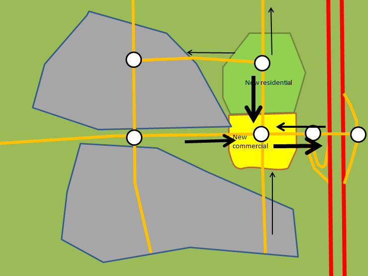 |
| New trips generated or attracted by the new developments and where they go |
 |
| Expected levels of service at intersections based on projected traffic levels, with unacceptably high congestion (F and E) at two intersections to the west of the highway) |
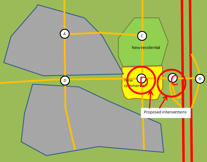 |
| Interventions (usually adding lanes to certain approaches) reestablish acceptable levels of service on the intersections with levels of service worse than D |
So that's how traffic studies are usually done. Seems sensible, doesn't it? You catch congestion upstream and adapt the roads for upcoming demand, making new developments pay. Well, let me count down the ways in which it this approach is terrible.
Assumptions, "conservative" approach and overdesign
The first issue when designing a traffic study is determining the number of trips generated by new developments. How can one proceed in this? Well, like all predictions, this is based on certain assumptions, overt or hidden, and past experience.
The bible here is the ITE's Trip Generation handbooks, which collects vehicle trip data from various locations depending on land use, then presents the result in the form of graph, based on a rate of trip per assumed relevant characteristics, for example, per 1000 square feet of Gross Floor Area.
By using that data as is, there are a flurry of assumptions that are made:
- All locations of a given land use with similar floor area (or other quantitative feature) will have a similar number of trips generated, it doesn't matter if it's a restaurant in the heart of a city or in a tiny town in the boondocks.
- Essentially all trips generated or attracted by the location will be made in cars.
- Congestion level and traffic conditions will have no effect on the number of trips made to and from that location.
Now, people may point out that these assumptions aren't always, or even frequently, true, but these still form the basis of most traffic studies. Why? Well, engineers are taught during their formation that being "conservative" with their calculations is always the best option. In this case, this has nothing to do with politics, it means always opting for more precaution, supposing higher loads than is plausible, so that the resulting design is sure to be able to withstand much bigger loads than it can be expected to face. This is rooted in structural engineering: someone who designs a bridge wants to avoid a catastrophic failure of the bridge, and so will overdesign the bridge for greater loads than necessary to make sure it doesn't happen, so loads will be high-balled and material resistance will be low-balled.
That makes plenty of sense for structural engineering, where failure destroys the structure and may even put human lives at risk, so that outcome is downright unacceptable. In that case, the cost of being conservative in one's calculations is merely a higher construction cost, there is no externality in most cases. So overdesigning a bridge has no drawback, except for the higher cost.
However, the problem comes when you apply that "conservative" mentality to traffic studies. In this case, it means assuming the worst case scenario of traffic, for instance, all different buildings have their PM peak flow at the same time, all trips are made by car, and using the Peak Hour Factor to suppose that all movements achieve their maximum 15-minute vehicle flows at the same time. It also means low-balling somewhat road capacity. So you're designing roads to avoid congestion at higher traffic levels than the roads will usually see.
This approach basically views congestion, even during the peak hour of the day, as a catastrophic failure in a way similar to a bridge falling down. It also assumes that there is no externality to overdesigning an intersection, of using longer traffic signals, of having a higher number of wider lanes, wider medians, the only drawback is the cost...
 |
| Overdesigned intersection, made to absorb the worst possible traffic flows that it can see |
...the reality is quite different. Huge intersections like these tend to result in high speed travel during most periods of the day when it is not congested, creating noise pollution and having the potential for very dangerous crashes. They also occupy a lot of land that could otherwise have been used for productive land uses to create value, weakening the tax base of the city. Their surplus capacity may also induce more vehicle traffic than would have happened otherwise. Finally, their huge size makes them a barrier to non-motorized travel.
Look at the earlier image, the pedestrian crosswalks are nearly 40-meter long (130-foot). It takes the better part of a minute for a pedestrian to cross the intersection, with vehicles turning left and right into his crosswalk while doing so, because with the time needed to cross the intersection, you can bet there is no exclusive, protected pedestrian phase. As a result of this phase, the cycle of the traffic signal probably approaches 3 minutes, and so the pedestrian delay to cross the intersection will probably be around 1 and a half minute, followed by nearly a minute of crossing an hostile intersection filled with fast-moving vehicles.
The result is that such an intersection forms a barrier to pedestrian and bicycle travel. The resulting roads that accompany these intersections are often large enough to make mid-block crossing a dangerous proposition to say the least, confining pedestrians to crossing only at rare intersections, often necessitating detours taking 5-10 minutes on foot... just to get on the other side of the road.
 |
| Another example of an overdesigned intersection, with the "Michigan left" on the East-West approaches, left-turning vehicles cannot turn at the intersection, must continue through and do U-turns in the bulbs you can see to the right and left, so they can just turn right at the intersection |
 |
| The overdesigned road forces residents of the mid-density housing (32 units per hectare, 12 per acre) on the bottom of the image to do a 650-meter detour to get to the store at the top, in order to gain access to a crosswalk where they can cross the road |
These externalities are ignored, it is considered to be "conservative" to spend more on a road with better vehicle capacity no matter the impact on quality of life of residents, on alternative modes of transport and on the financial sustainability of developments. This approach and the assumptions that support it make traffic studies a self-fulfilling prophecy: over-designing roads while neglecting non-car travel ensures that almost all trips in the area will be made by car, confirming the initial assumptions of quasi-universal car use, because cars are the only mode of travel the road design caters to.
To be fair, the most recent Trip Generation Handbook claims to address many of these failings by establishing some guidelines to differentiate mixed use developments from traditional sprawl, but I haven't had access to it.
Pushing developments to the fringe
Since either the developer or the city has to pay for any improvements to road capacity to deal with expected new trips, and the standard approach, up to now, didn't bother to account for a reduction in vehicle trips brought about by alternative modes of transport, this creates a perverse economic incentive. Essentially, developers are going to want to target areas of the road network that are not already at capacity and develop these rather than developing in already dense areas. That way, they can minimize the likelihood of paying for improvements, and even if they can't avoid it, they can minimize these costs.
What are the locations that are most likely to be congested? Central areas of course. In most metropolitan regions, the central city is still a strong draw for jobs if nothing else, drawing people from suburbs. So the traffic on a road tends to increase as one gets closer to the center of an urban area. Even locally, developed areas in suburbs will often have more traffic as long-distance trips and local trips overlap. Older areas also tend to have narrower roads with buildings built much closer to the sidewalks, making widening the road much more difficult and expensive.
 |
| A metropolitan area where a central city is connected with smaller urban areas through highways |
 |
| A likely congestion level for the major roads, red=congested, yellow=slightly congested, as a result, developments inside existing urban areas are more complicated and expensive as developers are asked to improve roads to obtain "acceptable" levels of service |
So traffic impact studies provide economic incentives for developers to spread developments all across the metropolitan area, to use every bit of unused road capacity before even considering densifying existing areas, and to avoid concentrations of buildings rather than favor areas that are walking and transit friendly. That is the very definition of sprawl: low-density developments spread uniformly on a large and growing area, necessitating cars to connect different land uses.
Short-sightedness of the process ironically leads to congestion
Even in the optic of preventing congestion, this process is a failure. The reason is that traffic studies only address the local impacts of traffic in most cases. However, due to the sprawling nature of developments and the presence of highways, it is quite likely that the majority of trips generated or attracted by a development will not come from the area considered by the traffic study.
 |
| In case there is a new development in the yellow area, the traffic study may be limited in scope to the area in the red box |
 |
| The area in a larger context, the red box is in the top left, with many trips coming from or going to highways to connect to other neighborhoods |
So though the traffic study may help avoid local congestion around the development, it will only channel more and more cars onto the major regional roads, which are not considered during that process. These major roads, usually administrated by DOTs or Transport Ministries, are often the only rapid links available to connect people with the rest of the region and will in essence be treated as car sewers by developers and planners, more and more cars will be fed to them, which eventually results in congestion. Of course, congestion of major regional roadways that are vital for freight transport inside a region is a major issue. As a consequence, these State/provincial entities will have to plan for more and more interventions on their roads to keep increasing capacity and deal with all the traffic cities bring into them. The result is, well...
 |
| ...this. This particular right-of-way is nearly 500 feet wide. |
If developments were instead allowed in already dense areas, since distances to stores and jobs are less and population density is higher, people who went to live in these places would be much less likely to use cars to get around. Since population growth in a metropolitan region is independent of developments, this means that if you force new residents to settle in car-dependent areas, to avoid local congestion in existing built areas, then you generate more and more congestion on the regional roadways which are vital to keep the region working because everything is so spread out. These roadways also happen to be at the charge of the State or province, so the cost of any capacity increase falls on all taxpayers, subsidizing far-flung suburbs who end up paying neither for local road improvements (largely paid by developers) nor for regional roads' improvement and upkeep (paid for by higher levels of governments.
So this is the lunacy of neighborhoods pushing out new developments because of fear of "congestion"... while the developments have to happen to house a growing population, so these developments are just going to happen further down the road, and the development's trips are still going to have to go through the area that refused them.
Incumbents gaming the system: impact on housing affordability
One final issue is about development economics. These studies often result in developers having to pay for interventions to prevent congestion levels from degrading, which means that the new tenants will have to pay for them through higher prices and rents. This is another way that incumbents have of using local municipal powers to give themselves certain guarantees while burdening newcomers with the price tag. The assumption is that incumbents are entitled to the same level of service they currently have, so newcomers have to pay 100% of the cost of any improvement meant to safeguard this level of service.
One car generates the same level of congestion whether it's driven by a new resident or an old-timer, so why should only newcomers have to pay to avoid the congestion generated by everyone? It is quite unfair, but that is the way that neighborhood opposition may be assuaged, at least somewhat.
From what I understand, the construction cost of new housing is vital to keeping housing costs down, even on the existing house stock. The cost of building new housing is what puts a ceiling on the price of housing, no one would pay 300 000$ for a house if they could have a similar house built for 250 000$ in the same area. The cheaper it is to build new housing, the more housing will be built, the more competition there will be and the slower prices will rise. It may even lead to older housing becoming less desirable and thus less valuable.
So when you heap on new developments the total infrastructure cost, you hike up construction costs, and as such set the stage for less affordable housing in the long run.
Conclusion
So these are my insights on traffic studies, based on my own personal involvement in them. These traffic studies only make sense in the context of sprawl, i.e. car-dependent development. In that respect, they achieve their goals in building relatively livable car-oriented areas, but they create financially unsustainable systems, increase transport needs and costs needlessly. The goal should not be to make sure that road networks are designed to allow everyone to use cars all the time to get anywhere, but to provide people with cities where they do not need to use cars and so there will be less cars on the road.
Traffic engineers need to stop considering congestion during peak hours to be "catastrophic failures". Congestion is not necessarily an engineering problem, in fact it is mainly an economic one, it is a mere shortage situation. It can be dealt with by offering alternatives to single-occupancy vehicles and by creating economic incentives to take these, either by giving preferential treatment to these modes to protect them from the effects of congestion or by directly targeting drivers through congestion fees and tolls


