Sunday, May 22, 2016

Land supply, the onion layer theory of sprawl and the crucial need for incremental density

One of the first articles I wrote for this blog illustrated the theory at the basis of my understanding of urban dynamics, that transport defined how a city grew and how it functioned. That the faster people travel around, the more developments will sprawl, because distance is measured in minutes, not miles, and proximity to a city's jobs and services is the reason why people live in the city in the first place.

A conclusion that I draw from this theory is that the size of a city is dependent on the speed of the main transport mode of residents. Hence why old cities tend to have clearly defined edges at roughly 5 kilometers from the center, which is the equivalent of one hour of walking.
Traditional Paris city has a diameter of 10 km, meaning people on the limits of the city can reach the center in one hour on foot
In effect, transport speed imposes an urban growth boundary on cities, if the area grows too large, the fringes become decoupled from the center of the region because it takes too much time to access the rest of the region. So, in a way, supposing a certain transport speed, you can imagine that there is a limited supply of land of varying quality in an urban area, depending on proximity to the center of economic activities and services, always remembering that proximity is measured in minutes, not miles.

So let's come up with an example of a city in a given area that looks like this:
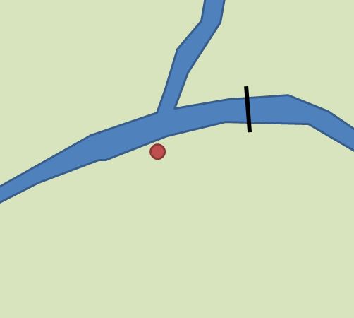
OK, so you have a river that cuts the area in three, there is only one bridge that allows to cross one branch of it, and the red dot represents the downtown of the urban area. Next, I'll divide the area between green, yellow and red areas, with the green representing the most desirable land due to proximity to downtown's jobs and services, the yellow representing lesser desirable locations and red representing marginal locations that stretch people's tolerance of distance.


So this represents roughly the city's "land supply". It roughly resembles three concentric circles, but the river is an obstacle to land supply, the only desirable locations north of the river is near the bridge to the east.

Note that this supposes that everyone travels at the same speed, which is not correct. People who expect to drive everywhere will tolerate much greater distances, land that is undesirable for a non-driver may yet be desirable for a driver.

If I were to ask where you would expect higher densities of construction, I'd wager most would say that the highest densities should be in the green area, the yellow should be lower density and the red should be low density. After all, cities can't and shouldn't be of uniform density everywhere, different people have different desires and needs, and higher densities should ideally be near jobs and services to allow as many people to access them in a short time as possible, that way you reduce transport needs for the entire city, while preserving people's ability to choose low-density housing if they so wish.

Well, that makes a lot of sense... if you were to build the entire city from a master plan in one shot. But that's not how cities are built, cities are built in stages over decades. Every year, the city's planners and developers make decisions that make sense for them at that moment in time.

Understanding this leads me to what I call the "onion layer theory of sprawl".

The onion layer theory of sprawl

The theory is based on the idea that low-density housing is actually the proper kind of development to expect from building on the fringe. The fringe is where land is most abundant and less desirable, so that it is cheaper. When a product is cheap, people tend to use more of it than absolutely necessary, that's true for gas, that's true for human labor and that's true for land. So having a bigger plot of land is affordable on the fringe.

For the planner, low-density housing is also more tolerable on the fringe. If you have a given amount of land on the fringe, since the location results in higher transport needs (people driving more often and longer distances), it's better to have fewer people there.

To use the earlier example, let's imagine we're only looking at a small town here, with the following urban area already built:
In this case, the green, desirable, land is still not fully built, the yellow, less desirable, land is still completely empty. If the city grows 1% each year, there's still plenty of land to go around, even green land, so the value of land will be very low. As a result, building low-density is affordable, and so it will likely be what ends up getting built.

Now, after a few years, the built area keeps growing and growing and you may get the following:

At this point, the desirable land is almost all gone, which will drive the value of land up in that area. However, on the fringe, there's still plenty of yellow land to go around, so the land value over there will be much cheaper, again, the new layer of construction will likely be low-density too, with a smattering of higher density housing in the remaining green area to develop.

And so it goes on :

Again, you are running out of yellow land, and now only the marginal land remains largely undeveloped. Again, lots in the green and yellow areas will see their value increase significantly, but there are few of them left. Meanwhile, land in the red area will remain largely affordable, inciting the new layer of development to again be of low-density.

So the resulting urban density looks a bit like this:

This is how the city starts, in red, the dense downtown, in orange the mid-density neighborhoods close to downtown, in green, the low-density suburbs

The first layer after development begins, since land is cheap on the fringe, it's likely to result in low-density developments

Another new layer of low-density developments

And on and on it goes...
So is there a way out? Well, the traditional answer was incremental construction, with progressive densification of the core even as the fringe was still being built. But with the advent of strict zoning rules, this way is too often closed, resulting in an almost uniform low-density sprawling city.

Ironically, at one point the city's sprawl may make it run out of land withing tolerable distance from the city's core. At that point, the planners and developers may both agree to start building higher density as land gets more expensive. This is not that uncommon, many metro areas have higher density developments in farther suburbs than inner suburbs because of that, since farther suburbs are more recent.

For example, here is a Google Earth image from the fringe of Calgary's urban area:
Recent developments on Calgary's fringe, dense single-family housing and 4-story apartment buildings
And here is an image from a neighborhood within 30-minute walk of downtown:
This leafy, low-density area is 30 minutes on foot from downtown Calgary

Location of previous images

Yes, you can build more land...

"Buy land, they're not making it anymore" is a common saying, attributed to Mark Twain. However, that is not true on an urban level. You CAN build land, or rather increase the supply of land of a given desirability. If you build transport infrastructure to increase travel speed, you are expanding the distance people will be willing to travel, which effectively increases land supply for urban development.

For example, let's return to the example before:

In this particular case, there is an obvious problem in that the river keeps land to the north of it from being desirable, as they're disconnected from the downtown area. But if you build new bridges, then...
...you can significantly expand the amount of desirable land for development. And if that's not enough, you can also speed up travel significantly in a given corridor by building an expressway passing near downtown:

This realization is important to understand the role freeways have in North American sprawl. Freeways, that are funded by Federal and State/provincial governments, are built in urban areas, which allows the supply of land to be significantly increased, yet those who benefit from this infrastructure largely do not have to pay for them. In effect, the DOTs/transport ministries are deeply involved in urban development because of this, yet they pretend ignorance and innocence in order not to get sucked in such debate.

Sprawl in North America is thus dependent on the construction of new roads all the time in order to increase the supply of land, and thus keep land prices low enough that low-density developments remain financially viable. This is in fact a great subsidy for sprawling cities and their suburbs. When that scheme fails due to geographical limits, like in Vancouver for example, then sprawl crashes and prices explode.

In recent years, some governments have started talking of the possibility of taxing land around transit as a "value capture" option... which is absolutely stupid since transit is largely funded by users and the people who reside near it already. If there is a reason to do this kind of "value capture", it would be to do it for freeways, not transit, since freeways are currently funded through indirect taxes on everyone and not through fees on users.

Conclusion

So I know a lot of things I wrote here may seem almost self-evident, but it's important to keep in mind that they have consequences. For one, since it makes sense to build every layer of a city's expanding border as low-density when it is built, it's important to make sure that our zoning and planning rules allow these areas to later densify organically to accommodate a rarefaction of land in the city, otherwise, prices may well explode. Likewise, since transport infrastructure spending increases the supply of land, it's important to take this effect into consideration, and ideally to charge those who benefit from them rather than simply fund such spending through general revenues.

Sunday, April 3, 2016

Police box: policing a walkable city

Much is often made in urbanist circles on how denser developments can foster a stronger community by bringing people closer together, but I'd like to make some observations on another crucial element of a community: law enforcement. Though much despised, policing forces are nonetheless an essential part of a community.

In most North American communities, police takes the curious form of clearly identified vehicles basically prowling the streets in search of violations (most often traffic violations). The analogy of police being predators hunting for prey is a bit too easy to make. This doesn't help police-community relations at all, because the isolation of private vehicles means that police will rarely be in contact with the community except when intervening, so police may come to see the community they're policing (especially if they don't live in it) as made up of only two types of people: law violators/criminals and victims begging for help. That's not a great way to develop a great relationship: "that community is full of criminals and people who flout the law all the time and hate us, but when they're in trouble, suddenly it's 'please mr policeman, save us!!!'".

When police are not in their cars, they're at the precinct or headquarters. And then there is another major urban design flaw. Jane Jacobs coined the term "eyes on the streets" to denote how open-designed buildings with plenty of windows can help make people feel safe because of the likelihood of people watching the street at any time, helping to make cities more safe. Well, if that is true, then what eyes would be more effective than police eyes? And yet, the North American design of police buildings is, well, lacking...
A neighborhood precinct in Montréal, with small windows with blinds or curtains, which is ironically one of the best designs of the examples I'll show here...
A precinct in Minneapolis, note the dearth of open windows at the ground level and the setback, but the worst is yet to come...
Behind these trees and parking lot could be any regular suburban office, but this is Arlington's (Texas) Police Department building
And this is the crowning achievement of shame, Glenn Heights' Police Department, in the suburbs of Dallas, no window on the road, which anyway is in the middle of nowhere. Might be useful in a zombie apocalypse, but otherwise...
The reason for this type of policing is easy enough to understand. With people dispersed everywhere over a large area, how can a few dozen policemen provide effective surveillance if they're not constantly on the move, at a speed that allows them to cover enough ground. This is a model that is also needlessly applied to dense neighborhoods which could have an alternative mode of policing.

Another unpleasant result of this is that policemen develop severe windshield perspective syndrome, since they spend their jobs at the wheel, they adopt the point of view of drivers, being more lax towards casual traffic violations by drivers and more likely to enforce jaywalking fines or the like on pedestrians and cyclists (and also, disrespecting bike lanes).

And what alternative mode is there? Well, again, Japan shows an interesting contrast.

The kouban, or police box

Japanese cities are a lot more dense than North American cities, even recent suburban developments often have 30 to 40 houses per hectare (12 to 16 per acre) and business/commercial districts remain many times more dense, and are often concentrated at train stations that connect the entire country, like surface subway lines (though often with 30-60+ minutes headway if not less in rural regions).

The Japanese therefore still use a specific mode of policing inherited from the pre-motorized era, with a focus on the kouban (交番), or police box. Here are a few examples of what they look like:
This is the plaza in front of Gotanda Station in Tokyo, the Kouban is circled in red...
...here is what it looks like, not the small size and the windows making up nearly all of the front, allowing the policeman occupying it to see outside easily
That small red building in the center of this business district is also a kouban
This kouban is at the entry point of Yokohama's chinatown, as you can see a policeman is standing right in front of it
It may be hard to see, but the small building at the center of this image is the Susukino Kouban in Sapporo, right in the middle of an entertainment/red-light district
The small building to the right is a kouban in Iwamizawa, a small suburb of Sapporo, near the train station and the walkable commercial core of the town
A kouban in touristic Matsushima, near the train station, with architecture respecting the traditional context of the town
Koubans stand out for being really small buildings, which allows them to be put nearly everywhere, and for having a really open design allowing people to look into it and for the policemen to look out of it. They are conveniently located in neighborhoods, often near concentrations of people and economic activities, to keep an eye out on the area and provide a greater feeling of safety.

These koubans also help people deal with regulations, koubans are involved in the "proof of parking" system and with the bike registry system. They also provide some certainty, when in trouble, people know where the police is, unlike in North America where you absolutely need to place a call to find the police. I think the location of these koubans in the middle of communities also helps foster a much better attitude in policemen towards the community, as they are less isolated from it, and also makes police part of community rather than a kind of occupying force, helping the community's attitude towards its police force.

Conclusion

There are a lot of tensions in North America between communities and their police forces. Perhaps more walkable, dense communities could open the door to having more policing done in static fashion, in places that maximize effectiveness rather than having police be prowling predators roaming the streets in vehicles. At the very least, North American police forces should perhaps do more patrols on bike and on foot to help bridge some of the gap between police and the community at large. A greater number of small police offices with an open architecture could also be a great idea, copying the success of the kouban model in Japan.

Wednesday, March 9, 2016

The case of one-way streets

Another common recommendation from urbanists in North America is the elimination of one-way streets, especially for main streets. The reasoning being that one-way streets reduce the access to commercial main streets, thus reducing their ability to reach certain customers and making businesses lose visibility. So I thought I might give my 2 cents as a traffic engineer on why certain cities have made their main thoroughfare one-way, and the impact on traffic and safety.

The reasons why certain streets have been made one-way

First, let's get a particular case out of the way. Certain residential streets in dense areas have been made one-way not for any traffic engineering reasons, but only because the street is relatively narrow and the planners wanted to have parking on both sides of the street, which didn't leave enough room for more than one travel lane in the center of the street.
8-meter wide street in the Plateau-Mont-Royal with parking on both sides, leaving only about 3,5 to 4,0 meters for a travel lane in the middle of the street (12 to 13 feet)
This is the kind of design that tends to be present only in old, dense areas of cities, where buildings have no off-street parking spots, where streets are relatively narrow and are in a strong grid format, allowing for easy detours. In recent developments, these conditions are pretty rare, streets are rarely in a grid, streets tend to be wider and there tends to be more off-street parking.

Some areas have also learned to use these one-way residential streets as a way to deter through traffic in residential areas, creating a maze of one-ways for cars despite the grid-like street network. Especially when a street's one-way direction changes, forcing people off the street to continue ahead.

Anyway, this type of one-way street tends to be of limited applicability. So let's look at a more contentious application, namely the one-way arterial.

Ste-Catherine street, 2-lane one-way arterial street with parking on either side
Maisonneuve, the "companion" to the above, being one-way in the other direction
OK, so what is the main point explaining why an arterial would be made one-way?

You might have expected it, it's about throughput capacity mainly. The main reason why one-way streets perform better capacity-wise is that what limits street capacity is intersections, and left turns especially can have a deleterious impact on capacity due to the conflict with vehicles coming from the opposite way. Left-turning vehicles therefore have to either wait for a gap in oncoming traffic, or have a separate phase (during which the flow of vehicle coming the other way will be interrupted). This is especially bad when the number of left-turning vehicles is high and when they share a lane with vehicles going straight.

With one-way streets, there is no issue with left-hand turns, they have the equivalent of a permanent priority phase. 
Depending on the number of left-turning vehicles, the second design probably has a capacity 20 to 40% higher than the first
What if you have a lane for left-hand turns only? Like the famous "road diet" design with one lane allowing straight and right-turns and a lane only for left-hand turns? Well, in that case, the effect of going one-way is even greater as it allows to have three lanes in each direction rather than just two, increasing throughput by at least 50%.

In this case, the second design actually increases capacity by at least 50% without requiring any wider street
So that's an obvious reason why traffic engineers find the one-way solution so attractive. When the goal is to move as many vehicles as possible in an hour, it is a very good solution. When the street is not capacity-constrained though, one-ways impose detours and can be annoying for drivers. But what are the effects of one-way streets aside from capacity? Are they safer or more dangerous?

Impact on speed

All else being equal, one-way streets are likely to result in faster speed in vehicles. Why is that? Because you are increasing the number of lanes per direction per street. When there is only the one lane going in one direction, the speed of traffic will actually be determined by the slower drivers, because drivers who tend to drive faster will be stuck behind them, not being able to pass. This keeps speeds low, obviously. When there are two lanes per direction, faster drivers have the ability to pass slower drivers, not only does this allow them to drive faster, but the effect of many cars passing slow drivers might intimidate these to speed up to match the speed of other vehicles on the road.  In effect, traffic speed is determined by the faster drivers.

So the more lanes per direction on a street there are, the higher the speed is likely to be. It's not the only factor, but it's an important one.

Higher speed is actually a mixed bag. For the traffic engineer, higher speed means higher mobility, which is generally an objective of their job. However, higher speeds in urban areas can mean more noise and more serious accidents, because kinetic energy increases with speed to the power of 2.

I know what some will say: why the hell would I want faster streets in my city? That's a good question, but in the end, in the modern economy, you need reasonable fast mobility for some trips in order to be able to tie regions together economically. Not all streets need to be fast, but some reasonably fast streets make sense to facilitate longer distances, and also to enable faster transit. In Montréal, it isn't rare for bus lines on one-way streets to be 50% faster than similar bus lines on similar streets that happen to be two-way streets.

Impact on accident risks

So one-way arterials are likely to have higher speeds compared to similarly wide two-way arterials, does that mean they're more likely to have crashes? Not really. Higher speeds tend to increase the likelihood of severe injuries in crashes, but not really increase the likelihood of crashes.

For pedestrians, one-way streets are actually not that bad, because they simplify vehicle movements, so they only have to look in one direction before crossing, whether at intersections or mid-block. This increases predictability for pedestrians, which is crucial for safe decision-making.

Also, one-way streets avoid one major issue that is often seen at intersections with traffic lights, the left hook. The issue here occurs during regular green lights that allow left turns while oncoming traffic still has its green, meaning the regular round solid green light. Drivers turning left thus have to wait in their lane for a gap in the traffic in front of them, which is where their attention will be concentrated.

When the driver sees a gap in the traffic in front, especially if traffic is heavy and he is frustrated, he will quickly exploit that gap and accelerate quickly to turn left across oncoming traffic. Meanwhile, not only was his attention not to his left, but the traffic is likely to have impaired his visibility of the pedestrian crossing to his left...


So if a pedestrian was crossing the street at the same time (or worse, a cyclist), you will have a dangerous situation where the left-turning driver is accelerating quickly towards a pedestrian he has not yet seen, which may result in a dangerous crash.  Even if the driver manages to stop before hitting the pedestrian, he becomes vulnerable to a side crash by the oncoming vehicle to his right.


With one-way streets, since there is no oncoming traffic, left-turning drivers will tend to keep their attention to their left, where they are going, which puts any crossing pedestrian well within their line of sight. Since they also don't need to exploit a gap, they may also accelerate slower, without a feeling of urgency.

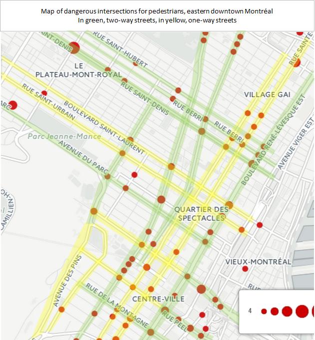
So this is all theoretical, do we have some empirical data? Well, more or less. Recently, a graph of pedestrian crash hot spots was made of Montréal, and I used my own knowledge of the streets to identify one-ways and two-way streets, superposing both to see if a pattern can be found:
In yellow, one-way streets, in green, two-way streets
I know from experience too that there are tons of pedestrians on all streets I've identified, so you can't explain away the discrepancy with the number of pedestrians. At worst, you can say there is no great difference in accidents between one-way and two-way streets, at best, you can notice a trend toward a lesser number of accidents on one-way streets. So I guess it confirms my intuition that one-way streets, for a similar number of lanes, do not decrease pedestrian safety, but are likely to increase it somewhat, at least at intersections.

Impact on trucks

First, say hello to my "friend" the WB-20 (Which due to my job I have dubbed in French the MCAM.... Maudit Camion À Marde... Goddamn Fucking Truck):
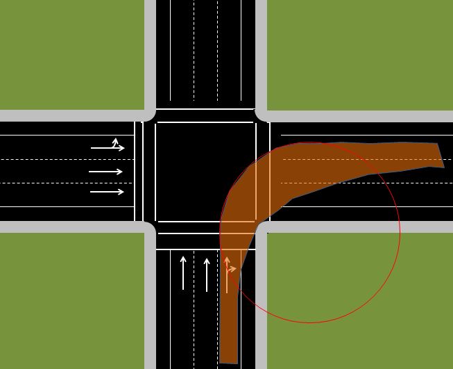
Turning template of the WB-20
What is a WB-20? It is the term used to describe the design vehicle for which all roads that receive Federal funding in the US have to be designed. It represents a semi-truck pulling a 53-foot trailer behind it. This is the usual truck size in the US, and since Canada is the US' toy poodle, the US standard has also been adopted north of the border.

This truck is the death of old towns. Why? Because to simplify freight, trucking companies much prefer to stick to the 53-foot trailer size, even for local deliveries. But city streets aren't made for such huge behemoths, even North American main streets. This might be part of the reason why many stores prefer the periphery over a main street location, to avoid the hassle of having 53-foot trailers making deliveries down narrow streets.

In comparison, most of Europe limits trailer sizes to 12 meters (40 feet), which North American norms call a WB-15, which turns much better:
In orange, the turning template of the WB-15 superposed on that of the WB-20
Note that an alternative might have been to adopt a standard of trucks pulling two shorter trailers, which, like articulated buses, result in a better turning area:
The WB-20D, same capacity as a WB-20, but much better turner

In red the turning area of a WB-20D, superposed over a WB-20.
Anyway, the WB-20 standard also explains why most highways have extremely wide curbs at intersections, exactly to allow this kind of vehicle to turn.

Unfortunately, these trucks are the lifeblood of the economy. They deliver materials to factories then deliver goods to businesses. It sucks, but it is what it is, if you want a city to be economically viable, it is best to find a way to welcome these huge trucks on streets. Yes, I know it would be best to force truck companies to use smaller trucks in cities, but unless the regulation is made at the national level, I doubt it would be enforceable.

So let's look what a turning WB-20 would look like on a "road diet" street with 1 lane per direction plus a center lane for left turns and space for parked cars on either side (about 13 meters wide minimum, 44 feet):

Notice the problem? A truck in its right lane turning right would need to get on the wrong side of the street for nearly 20 meters (nearly 70 feet). Since there may be cars stopped at the stop line, that stop line would have to be pushed WAY back. It's obviously not a comfortable situation for anyone. You could also widen the street with a big curb at the corner...

But in many ways the cure is worse than the disease, especially since pedestrian crossing length would jump from about 14 meters to 22 meters if done on all corners. If you think this is just theoretical, think again, why do you think intersections like these ones are made?


Meanwhile, let's look at that same WB-20 turning with one-way streets of the same width:

Here, there is no problem, even if the truck goes into the center or left lane, as they also go in the same direction, it can easily go there without any danger to anyone. So one-way streets are a way to allow big trucks into cities without transforming intersections into the abominations I just showed, while maintaining adequate pedestrian safety.

Conclusion

One-way streets are certainly not the best solution everywhere in a city. However, I do believe that it would be foolish to turn our back on them, they are a good solution to a particular problem, namely how to deal with long North American trucks and provide adequately fast streets for longer distances, both for cars and for buses. In fact, I think that this design in urban areas is far preferable to the huge 6-lane arterial which we unfortunately see too often in suburbs.

The kind of suburban arterial that could and should be replaced by a pair of 3-lane one-way streets separated by 100 meters
However, on commercial main streets where the focus should be on pedestrians and slow traffic, two-way streets are the better solution.