Traffic studies, or traffic impact assessments, are a big part of the job of a traffic engineer. They are an oft-forgotten part of how urban developments occur, but they should not be forgotten, because they are one of the worst obstacles there are against denser, less car-centric developments. I've seen first hand how they worked.
The idea is that before any development occurs, a traffic study must be made to predict the impacts of this new development on the current road network. The traffic study generally goes down this way:
 |
| Here is an area to be studied, in gray, the existing developed zones, the yellow lines are the major arterial network and the red lines are an highway |
 |
| New residential and commercial developments proposed by developers and/or city planners |
 |
| Current levels of service of intersections during worst peak hour |
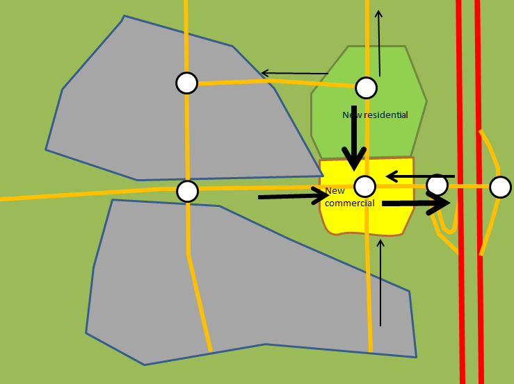 |
| New trips generated or attracted by the new developments and where they go |
 |
| Expected levels of service at intersections based on projected traffic levels, with unacceptably high congestion (F and E) at two intersections to the west of the highway) |
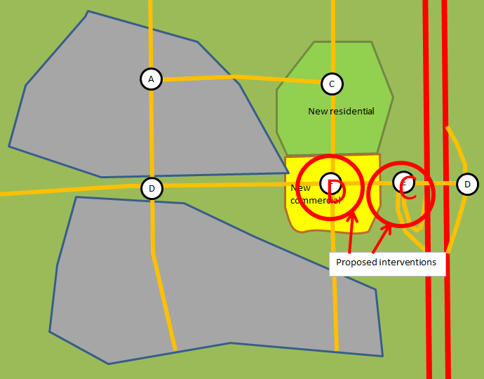 |
| Interventions (usually adding lanes to certain approaches) reestablish acceptable levels of service on the intersections with levels of service worse than D |
So that's how traffic studies are usually done. Seems sensible, doesn't it? You catch congestion upstream and adapt the roads for upcoming demand, making new developments pay. Well, let me count down the ways in which it this approach is terrible.
Assumptions, "conservative" approach and overdesign
The first issue when designing a traffic study is determining the number of trips generated by new developments. How can one proceed in this? Well, like all predictions, this is based on certain assumptions, overt or hidden, and past experience.
The bible here is the ITE's Trip Generation handbooks, which collects vehicle trip data from various locations depending on land use, then presents the result in the form of graph, based on a rate of trip per assumed relevant characteristics, for example, per 1000 square feet of Gross Floor Area.
By using that data as is, there are a flurry of assumptions that are made:
- All locations of a given land use with similar floor area (or other quantitative feature) will have a similar number of trips generated, it doesn't matter if it's a restaurant in the heart of a city or in a tiny town in the boondocks.
- Essentially all trips generated or attracted by the location will be made in cars.
- Congestion level and traffic conditions will have no effect on the number of trips made to and from that location.
Now, people may point out that these assumptions aren't always, or even frequently, true, but these still form the basis of most traffic studies. Why? Well, engineers are taught during their formation that being "conservative" with their calculations is always the best option. In this case, this has nothing to do with politics, it means always opting for more precaution, supposing higher loads than is plausible, so that the resulting design is sure to be able to withstand much bigger loads than it can be expected to face. This is rooted in structural engineering: someone who designs a bridge wants to avoid a catastrophic failure of the bridge, and so will overdesign the bridge for greater loads than necessary to make sure it doesn't happen, so loads will be high-balled and material resistance will be low-balled.
That makes plenty of sense for structural engineering, where failure destroys the structure and may even put human lives at risk, so that outcome is downright unacceptable. In that case, the cost of being conservative in one's calculations is merely a higher construction cost, there is no externality in most cases. So overdesigning a bridge has no drawback, except for the higher cost.
However, the problem comes when you apply that "conservative" mentality to traffic studies. In this case, it means assuming the worst case scenario of traffic, for instance, all different buildings have their PM peak flow at the same time, all trips are made by car, and using the Peak Hour Factor to suppose that all movements achieve their maximum 15-minute vehicle flows at the same time. It also means low-balling somewhat road capacity. So you're designing roads to avoid congestion at higher traffic levels than the roads will usually see.
This approach basically views congestion, even during the peak hour of the day, as a catastrophic failure in a way similar to a bridge falling down. It also assumes that there is no externality to overdesigning an intersection, of using longer traffic signals, of having a higher number of wider lanes, wider medians, the only drawback is the cost...
 |
| Overdesigned intersection, made to absorb the worst possible traffic flows that it can see |
...the reality is quite different. Huge intersections like these tend to result in high speed travel during most periods of the day when it is not congested, creating noise pollution and having the potential for very dangerous crashes. They also occupy a lot of land that could otherwise have been used for productive land uses to create value, weakening the tax base of the city. Their surplus capacity may also induce more vehicle traffic than would have happened otherwise. Finally, their huge size makes them a barrier to non-motorized travel.
Look at the earlier image, the pedestrian crosswalks are nearly 40-meter long (130-foot). It takes the better part of a minute for a pedestrian to cross the intersection, with vehicles turning left and right into his crosswalk while doing so, because with the time needed to cross the intersection, you can bet there is no exclusive, protected pedestrian phase. As a result of this phase, the cycle of the traffic signal probably approaches 3 minutes, and so the pedestrian delay to cross the intersection will probably be around 1 and a half minute, followed by nearly a minute of crossing an hostile intersection filled with fast-moving vehicles.
The result is that such an intersection forms a barrier to pedestrian and bicycle travel. The resulting roads that accompany these intersections are often large enough to make mid-block crossing a dangerous proposition to say the least, confining pedestrians to crossing only at rare intersections, often necessitating detours taking 5-10 minutes on foot... just to get on the other side of the road.
 |
| Another example of an overdesigned intersection, with the "Michigan left" on the East-West approaches, left-turning vehicles cannot turn at the intersection, must continue through and do U-turns in the bulbs you can see to the right and left, so they can just turn right at the intersection |
 |
| The overdesigned road forces residents of the mid-density housing (32 units per hectare, 12 per acre) on the bottom of the image to do a 650-meter detour to get to the store at the top, in order to gain access to a crosswalk where they can cross the road |
These externalities are ignored, it is considered to be "conservative" to spend more on a road with better vehicle capacity no matter the impact on quality of life of residents, on alternative modes of transport and on the financial sustainability of developments. This approach and the assumptions that support it make traffic studies a self-fulfilling prophecy: over-designing roads while neglecting non-car travel ensures that almost all trips in the area will be made by car, confirming the initial assumptions of quasi-universal car use, because cars are the only mode of travel the road design caters to.
To be fair, the most recent Trip Generation Handbook claims to address many of these failings by establishing some guidelines to differentiate mixed use developments from traditional sprawl, but I haven't had access to it.
Pushing developments to the fringe
Since either the developer or the city has to pay for any improvements to road capacity to deal with expected new trips, and the standard approach, up to now, didn't bother to account for a reduction in vehicle trips brought about by alternative modes of transport, this creates a perverse economic incentive. Essentially, developers are going to want to target areas of the road network that are not already at capacity and develop these rather than developing in already dense areas. That way, they can minimize the likelihood of paying for improvements, and even if they can't avoid it, they can minimize these costs.
What are the locations that are most likely to be congested? Central areas of course. In most metropolitan regions, the central city is still a strong draw for jobs if nothing else, drawing people from suburbs. So the traffic on a road tends to increase as one gets closer to the center of an urban area. Even locally, developed areas in suburbs will often have more traffic as long-distance trips and local trips overlap. Older areas also tend to have narrower roads with buildings built much closer to the sidewalks, making widening the road much more difficult and expensive.
 |
| A metropolitan area where a central city is connected with smaller urban areas through highways |
 |
| A likely congestion level for the major roads, red=congested, yellow=slightly congested, as a result, developments inside existing urban areas are more complicated and expensive as developers are asked to improve roads to obtain "acceptable" levels of service |
So traffic impact studies provide economic incentives for developers to spread developments all across the metropolitan area, to use every bit of unused road capacity before even considering densifying existing areas, and to avoid concentrations of buildings rather than favor areas that are walking and transit friendly. That is the very definition of sprawl: low-density developments spread uniformly on a large and growing area, necessitating cars to connect different land uses.
Short-sightedness of the process ironically leads to congestion
Even in the optic of preventing congestion, this process is a failure. The reason is that traffic studies only address the local impacts of traffic in most cases. However, due to the sprawling nature of developments and the presence of highways, it is quite likely that the majority of trips generated or attracted by a development will not come from the area considered by the traffic study.
 |
| In case there is a new development in the yellow area, the traffic study may be limited in scope to the area in the red box |
 |
| The area in a larger context, the red box is in the top left, with many trips coming from or going to highways to connect to other neighborhoods |
So though the traffic study may help avoid local congestion around the development, it will only channel more and more cars onto the major regional roads, which are not considered during that process. These major roads, usually administrated by DOTs or Transport Ministries, are often the only rapid links available to connect people with the rest of the region and will in essence be treated as car sewers by developers and planners, more and more cars will be fed to them, which eventually results in congestion. Of course, congestion of major regional roadways that are vital for freight transport inside a region is a major issue. As a consequence, these State/provincial entities will have to plan for more and more interventions on their roads to keep increasing capacity and deal with all the traffic cities bring into them. The result is, well...
 |
| ...this. This particular right-of-way is nearly 500 feet wide. |
If developments were instead allowed in already dense areas, since distances to stores and jobs are less and population density is higher, people who went to live in these places would be much less likely to use cars to get around. Since population growth in a metropolitan region is independent of developments, this means that if you force new residents to settle in car-dependent areas, to avoid local congestion in existing built areas, then you generate more and more congestion on the regional roadways which are vital to keep the region working because everything is so spread out. These roadways also happen to be at the charge of the State or province, so the cost of any capacity increase falls on all taxpayers, subsidizing far-flung suburbs who end up paying neither for local road improvements (largely paid by developers) nor for regional roads' improvement and upkeep (paid for by higher levels of governments.
So this is the lunacy of neighborhoods pushing out new developments because of fear of "congestion"... while the developments have to happen to house a growing population, so these developments are just going to happen further down the road, and the development's trips are still going to have to go through the area that refused them.
Incumbents gaming the system: impact on housing affordability
One final issue is about development economics. These studies often result in developers having to pay for interventions to prevent congestion levels from degrading, which means that the new tenants will have to pay for them through higher prices and rents. This is another way that incumbents have of using local municipal powers to give themselves certain guarantees while burdening newcomers with the price tag. The assumption is that incumbents are entitled to the same level of service they currently have, so newcomers have to pay 100% of the cost of any improvement meant to safeguard this level of service.
One car generates the same level of congestion whether it's driven by a new resident or an old-timer, so why should only newcomers have to pay to avoid the congestion generated by everyone? It is quite unfair, but that is the way that neighborhood opposition may be assuaged, at least somewhat.
From what I understand, the construction cost of new housing is vital to keeping housing costs down, even on the existing house stock. The cost of building new housing is what puts a ceiling on the price of housing, no one would pay 300 000$ for a house if they could have a similar house built for 250 000$ in the same area. The cheaper it is to build new housing, the more housing will be built, the more competition there will be and the slower prices will rise. It may even lead to older housing becoming less desirable and thus less valuable.
So when you heap on new developments the total infrastructure cost, you hike up construction costs, and as such set the stage for less affordable housing in the long run.
Conclusion
So these are my insights on traffic studies, based on my own personal involvement in them. These traffic studies only make sense in the context of sprawl, i.e. car-dependent development. In that respect, they achieve their goals in building relatively livable car-oriented areas, but they create financially unsustainable systems, increase transport needs and costs needlessly. The goal should not be to make sure that road networks are designed to allow everyone to use cars all the time to get anywhere, but to provide people with cities where they do not need to use cars and so there will be less cars on the road.
Traffic engineers need to stop considering congestion during peak hours to be "catastrophic failures". Congestion is not necessarily an engineering problem, in fact it is mainly an economic one, it is a mere shortage situation. It can be dealt with by offering alternatives to single-occupancy vehicles and by creating economic incentives to take these, either by giving preferential treatment to these modes to protect them from the effects of congestion or by directly targeting drivers through congestion fees and tolls
Do traffic studies consider the possibility that new development might replace earlier trips instead of just creating new ones? Like if a shopping centre is built near a neighbourhood, people will shop there instead of the more distant shopping centre they used to go to? How about multi-destination trips? Like in your example, if someone is coming back from work on the highway, they might stop in the new commercial area on the way home to get things for dinner. In terms of distance driven, it's basically the same so congestion impacts should be relatively little (just the impact of the extra turns in/out of the shopping centre).
ReplyDeleteThe fact that they're only looking at a small area for traffic impact studies is what surprises me the most though. If you look at how much driving the average person does, much of it is on high speed high volume roads and over long distances. Evidence of this can be found by looking at local streets serving high density developments, such as Village Green Square in Toronto, a dead end that serves a large office tower, large hotel and 4 large condo towers plus townhouses, and it has relatively little traffic.
Even stranger is the idea that local trips cause peak hour congestion. First of all, local trips have a high potential for being done by foot, bike or transit if the community is well designed. Long distance trips to regional malls or business parks are more likely to be done by car. Not only that, but local trips are less likely to be commute trips, which means there's no reason why they would be strongly concentrated around rush-hour even if it was easy to get around during rush-hour.
The methodology does include consideration for pass-by trips and internal trips. That at least is considered. But for the purpose of a traffic study, the fact that building a new store may erase some trips elsewhere is usually irrelevant. All that matters are the trips in the area studied, that some trips elsewhere may be affected has no impact on the study.
DeleteOne of the reasons why the study is local is that the larger the area studied, the harder it is to make worthwhile predictions, up to a point where predictions will be worth nothing at all. The idea is also that it is the DOT/transport ministry who is responsible for regional roads, so it's up to them to make their own studies on regional traffic patterns. Of course, the difference is that DOTs/transport ministries generally have no power to control developments like cities have.
Local trips can cause congestion because long-distance trips act essentially as some kind of background traffic level that travels a long area. Local trips come add up to that base level and may cause congestion to be higher in an area than in other areas of the same road. Local trips can be made without car, but that's the thing, this is generally not considered. It doesn't help that the result of this process is often to make developments occur in places where non-car travel is unlikely, making the assumption that almost all people will take cars a self-fulfilling prophecy: the assumption turns out to be right because decisions taken to deal with traffic make competing modes uncompetitive.
Do you think having development charges based on VMT generated by the new development would work better?
DeleteAnd in the GTA at least, a lot of the regional (arterial) roads are maintained by local governments and have an important role in serving medium distance commute trips. Admittedly the congestion on the arterials is often near freeway interchanges since traffic volumes increase as you get closer and closer to the highways.
I find the idea of taxing developers for the predicted behavior of future residents is wrongheaded. Developers just pass that cost down to buyers, so you end up punishing people for a predicted behavior whether they conform to it or not. Imagine if instead of having police ticket people who park illegally in the street, the city would just send fines to every household, equal to half a parking ticket with the reasoning that "in general, we distributed 10 000 parking tickets in this neighborhood that has 20 000 households, so instead of actually enforcing the law, we'll just send every household half a ticket to pay for the illegal parking that occurs anyway, which we will no longer have police enforcing". Does that sound like a good idea? Not to me it doesn't.
DeleteI understand that taxing the developers is an easy way out, developers aren't much liked, so it's politically easy to do. But economically, when you want to discourage a certain behavior, like driving a car in a congested area, then you must tax that particular behavior to be really efficient (ex: congestion charge). Even if people overall hate having to pay for using public infrastructure, we need to keep in mind that this is by far the best option: price is an information vehicle on which people based their decisions as consumers, when you get rid of it, you deprive people of informations to make the better choices.
All those folks who think that the developers actually pay are forgetting that the cost " flows through" to the purchaser or user in terms of rents or price...
DeleteSomething that has always confused me is how traffic projections have been in continuous use for decades and I've yet to see the mathematics behind their derivation despite poring over dozens of them, reading design manuals, etc. They are locked behind pay walls in trade-secret publications.
ReplyDeleteI never see them compared to real life traffic data. Here in Los Angeles, we have a multi-billion dollar system called "ATSAC" with loop detectors at nearly ever signalized intersection in the city. With the data from those loop detectors we should be able to create an unbelievably accurate predictive model for all sorts of land use and street design changes. Yet nobody has formally done so. In fact, the data from this system is deleted every 30 days.
Another writer once called modern transportation planning an "infrastructure cult" akin to the "cargo cults" of Papua New Guinea. I tend to agree with that assessment.
You sure have that right. Transportation planning as yet another California cult. You need look no further than carpool lanes for proof of this. They have sprung up throughout California and have spread their infection nationwide (and probably internationally), but they have the opposite effect of what they are proposed to do. HOV lanes increase congestion, increase pollution, and are generally a very stupid idea that should be outlawed. But here in CA, we haven't added a general purpose lane in 15 years. Only carpool lanes. Go figure.
DeleteThey aren't hidden at all -- the empircal data which has been collected over the last half century -- and used in the development of such resources as the Highway Capacity Manual -- are available for anyone to download, purchase, and review.
ReplyDeleteThis comment has been removed by the author.
ReplyDelete>> So traffic impact studies provide economic incentives for developers to spread
ReplyDelete>> developments all across the metropolitan area, to use every bit of unused road
>> capacity before even considering densifying existing areas
The author is not recognizing – or understanding – that traffic studies are requirements of many townships. Developers rarely engage a traffic engineer for any reason other than it is a requirement to navigate the gauntlet of land development.
A developer often identifies a site and the project long before the traffic engineer is retained. Thus most traffic impact studies have no influence or provide any incentive to developers regarding “where” to site a project. Developers choose a location based on expected/hoped success. They frequently deal with impacts and mitigations after the location has been identified. In fact, sometimes the infeasibility of a site (due to traffic, or stormwater management, or steep slopes) can alter or kill a project.
>> So though the traffic study may help avoid local congestion around the development,
>> it will only channel more and more cars onto the major regional roads
The scope of a traffic study is based on which intersections will have the most impact from a project. Most trips are absorbed/processed by the closest intersection. As you get further away, the effects of trip distribution mean the impact becomes more reduced. Major arterial roadways are usually somewhat distanced from a site, and the actual number of trips attributable to a project on said roadways may not even be measurable.
Something also not mentioned is that certain developments generate very little – or no – “new” traffic at all. This concept – passby – is easy to understand but something the author fails to mention. A convenience store, for example, generates very few NEW trips – rather they tend to be patronized by motorists already existing along a given roadway. These types of development contribute virtually no added traffic to any roadway in a study area, including regional arterials.
I know that traffic studies are requirements of DOTs and municipalities. However, I think that you can't have developers go through that process a few times without them developing a knack to figure out which areas will be difficult to deal with and which will be easy. The impacts of traffic studies are likely to occur upstream of the traffic study, development projects that may run afoul of the studies may simply be abandoned or modified before they even get to the traffic study phase, in expectation of it.
DeleteThere are certainly arguments for the small scope of traffic studies, at a certain distance, the predicted impact may be small and uncertainty may make any prediction not worth the paper it's printed on. However, these impacts do not disappear just because they're hard to predict, and they accumulate over many developments until these impacts, which are perhaps insignificant when taking individually, affect greatly the performance of the regional road network. That is especially true for highways and other major roadways which become more and more vital as developments spread farther apart, resulting in a very fragile network where a few high-speed roads become crucial for the region and are always at capacity during peak hours, in a situation where any reduction of capacity due to accident or construction may provoke a total failure of the road network in the area.
>> I think that you can't have developers go through that process a few times without them developing a knack to figure out which areas will be difficult to deal with and which will be easy. The impacts of traffic studies are likely to occur upstream of the traffic study, development projects that may run afoul of the studies may simply be abandoned or modified before they even get to the traffic study phase, in expectation of it.
DeleteI can tell you without hesitation that you are wrong about this. Developers are looking to make money. They don't think about road infrastructure costs unless it is extremely obvious. Even major traffic infrastructure remedies -- and their attendant high costs -- are just 'one shot' expenses which a very successful project can easily absorb in its proforma. I have worked for the same developers (some of whom aren't even 'developers' in the traditional sense -- some are universities and school districts, for example) for a long time and can tell you that when they want to build a new shopping center or a new school they things they think about the most are where the need is the greatest -- the infrastructure matters are secondary.
>>highways and other major roadways which become more and more vital as developments spread farther apart, resulting in a very fragile network where a few high-speed roads become crucial for the region and are always at capacity during peak hours, in a situation where any reduction of capacity due to accident or construction may provoke a total failure of the road network in the area.
I totally agree with you here. Many major metro areas in the US have witnessed huge rises in populations in recent years. According a former mayor of Philadelphia, in 1992 there were 58,000 residents of the urban core of Philly (Center City as we call it). Today there are almost 200,000. Even though the population has more than tripled, there has been NO increase in road infrastructure capacity. In fact, there has been widespread loss of capacity as through lanes which were viewed as superfluous have been exchanged for bicycle lanes or other systemic improvements. As you say, individually, these exchanges mean little, but collectively, they are significant. Its no wonder that traffic on the few remaining arterials and expressways around/through the city are always congested -- what would one expect when the number of residents / employees increases and at the same time capacity is stripped away?
Only very large developments can absorb the costs of major interventions without hurting the bottom line. Infill developments are another matter, and densifying suburbs become nearly impossible.
DeleteAs to Philadelphia, I cannot agree less. The fact is that if you think only in terms of single-occupancy vehicle capacity, then yes, you'd think that a growing population/job center would need to have a proportional increase in vehicular capacity. But in reality, cities can manage other ways to increase passenger capacity. For example, on a street grid, often you can only achieve about 1 000 vehicles per hour per lane before intersections start creating congestion, that's 1 200 or 1 300 people per hour per lane at typical occupancy. But a single bus line with 40-ft buses can carry up to 2 000 people per hour on 30 vehicles per hour, so using about 5% of road capacity, buses can boost passenger capacity by more than 100%. Bike lanes and pedestrians can also add to passenger capacity. Of course, these modes are slower, which is why you need density for them to be viable, the same density that makes it harder to get projects approved when you do traffic studies, because assumptions of massive car use and density of trip generators would lead people to conclude that these developments would create pure gridlock... yet, looking at Montréal, the densest areas of the city generate a fraction of the car trips of the suburbs, though congestion happens there, it is not local residents who generate it. You could bulldoze over these neighborhoods and there would still be congestion there.
An alternative approach to dealing with the issue you mentioned is to restrict parking. Ottawa, for example, limited downtown parking with maximum parking rules. These forced employees to find other ways of going to work downtown, resulting in very high transit use, even before the BRT was built. And since roads tend to have plenty of residual capacity outside of commute times, just solving the issue of commuting solved the issue of road capacity for Ottawa... well, until there was bus congestion downtown, requiring conversion to LRT.
>>If developments were instead allowed in already dense areas, since distances to stores
ReplyDelete>>and jobs are less and population density is higher, people who went to live in these
>>places would be much less likely to use cars to get around.
While there is some truth to this statement, it ignores trip purpose. I live within one mile of Whole Foods. I visit it almost weekly. I’d rather not deal with carrying groceries on my back or try to fit it in the pannier of my bicycle, so I always use my car. When I visit my father in South Philly I also always use my car. Sometimes I stop by Kermits on Washington Avenue to pick up some of their pizza, which is also more convenient to carry in my car. Sometimes its raining or snowing and I prefer to use my car, even for short trips. No matter what the weather is like or what the trip purpose is, my time is very valuable, and if it takes 40 minutes to perform a task by walking, 20 minutes to perform do it by biking, or 10 minutes to perform the same task by driving, driving will win every time.
>>Traffic engineers need to stop considering congestion during peak hours to be
>>"catastrophic failures". Congestion is not necessarily an engineering problem.
Traffic engineers are hired to address code requirements of municipalities and DOTs. They perform investigations with neither passion nor prejudice. Often it is the local government that views congestion as an engineering problem and expects the developer to not only address his impact (as caused by the new trips a development may bring to an area), but also solve existing congestion problems for which he often bears no responsibility. The purpose of the traffic study is to identify these differences and propose solutions. Ideally, additional congestion is not created and people are able to spend more time being productive, being with their families, etc (rather than stuck in traffic), less fuel is wasted, fewer emissions are produced, etc.
I wouldn't call having a grocery one mile away "close". Anyway, though some people are loath to leave their car at home, I was talking of statistical realities here. Furthermore, one element I didn't mention for brevity's sake is that many trips are also elective and can be displaced in time. For example, a supermarket in a congested area may attract many pass-by trips, but people who want to go there from their home could elect to wait the peak hours out to avoid congestion or difficulty in finding a parking spot. This is one of the ways in which trips are an economical problem, with congestion and discomfort providing an incentive to people to seek out better times to visit the store.
DeleteThis is all a very complicated matter, but it's too often just solved by going to the ITE's Trip Generation manual and using the numbers presented as is
A further issue is that engineers in this situation are placed in a difficult position. Planners and developers want traffic studies to be done and heap it on the engineers, who are supposed to be a-political and impartial and propose technical solutions. But the issue of congestion is mainly about economics and can be tackled by certain policies. Engineers may know this but feel compelled by their professionalism to avoid making any policy recommendation by fear of going beyond their mandate and substituting themselves to politicians and other policy makers. At the same time, these politicians and policy makers may start relying on engineers too much.
So policy makers base their policies on what engineers say, but engineers make purely technical and engineering proposals to issues because that is what they are comfortable dealing with and want to avoid treading in partisan waters. What I'm saying is that engineers need to understand this, understand their position as experts and so remind policy makers that there are alternatives to the "improve road capacity to maintain current LOS" solution to growing populations.
>>This is one of the ways in which trips are an economical problem, with congestion and discomfort providing an incentive to people to seek out better times to visit the store.
ReplyDeleteEconomic (money) does not factor at all into this "displacement in time" argument. Your argument is that people may avoid travel during peak hours to avoid congestion associated therewith. That individual making trips at a later time is thus still fundamentally rooted in congestion (LOS) issues and has nothing to do with economic factors. Maybe you should try explaining this a different way since it seems to make no sense at all.
>>just solved by going to the ITE's Trip Generation manual and using the numbers presented as is
Many traffic studies I have prepared (and reviewed) apply credits for peds, bikes, mass transit, and/or any other applicable non-auto mode. Even if they didn't, some would find less issue with the lack of credits -- the potential overstatement of vehicular trips could be viewed by some as a conservative approach.
>>policy makers base their policies on what engineers say,
In my 22 years of experience, appearing before hundreds of boards of elected officials, I can tell you that policy makers base their policies (and votes) on: (1) what they believe their constituencies want and (2) what they believe is right. Most boards have an in-house or on-call traffic engineer who not only reviews the traffic studies prepared on behalf of applicants, but also provide their own views on both immediate and long-term issues. Sometimes the elected official / policy maker considers these opinions, sometimes they don't. You appear to overstate the role of the traffic engineer in both site selection and policy decisions. Greatly overstate, in fact. Perhaps things are different in Canada.
Economic analysis needs not always refer to money. Congestion can be calculated as a "cost" or "price" of travel (though it ought perhaps be more considered as a reduced benefit of travel... but mathematically, it produces pretty much the same outcome). The idea is that worse LOS can convince users to plan trips outside of congested hours, thus achieving a balance between demand and supply.
Delete"the potential overstatement of vehicular trips could be viewed by some as a conservative approach."
That is exactly the issue I decried here. It is wrong to assume that overstatement of vehicular trips is a conservative approach. Overstatement of vehicular trips leads to overdesigned roads that create barriers to non-vehicular trips, reduce safety and reduce the quality of life of residents. Overdesigning a bridge to be conservative has a higher cost, but it has no externality. Overdesigning road systems has significant externalities that hurt communities. Furthermore, overdesigning a bridge makes a lot of sense because the cost of failing to do so is terrible, both financially and in terms of human lives, but why should congestion be so feared? It's nowhere near similar to bridges collapsing, a few hours of congestion each day doesn't make cities unlivable, some of the wealthiest, most successful cities in North America are ALSO the most congested.
To be clearer regarding the relationship between engineers and policy, policy-makers tend to draw policy based on the conventional wisdom with input from engineering groups. But in terms of the application of rules, politicians frequently defer to traffic engineers in terms of specific applications: if the engineer says that the project requires X and Y, the politicians will make that request. A policy that says new developments must provide traffic studies and developers must implement recommendations is a policy that has politicians directly defer to engineers, making congestion an engineering problem.
Just to make it clear, if the goal is to build car-dependent sprawl, traffic studies work perfectly fine. But then the result is "drive or starve" sprawl that is financially unsustainable and has negative impacts on health and communities. The alternative title idea I had was "The SMART idiocy of traffic studies", because the process isn't completely indefensible, in a certain context, it makes sense. But when you expand the analysis and question whether traffic studies and the logic behind them create cities and communities we want, I think the answer is clearly: NO. The unquestioned assumptions of the method need to be questioned, because when you decide to plan cities to make sure that everyone can get anywhere with a car at any time without congestion, then you may achieve the result, but you also get a city where people NEED to use cars to get anywhere.
The problem with traffic studies isn't that they exist, it's that they generally focus solely on moving cars and assume no other alternatives. The great failure of the studies and of traffic engineers themselves is that the only mitigation options provided are "move more cars", which frequently even cut off other alternative options. If traffic studies would instead start offering mitigation measures based on prioritizing the most efficient mode for a corridor based on its function, that'd fix the majority of the problem with the studies.
ReplyDeleteAs for having developers pay the improvements and passing those costs to residents, that's pretty fair. Especially in some newer cities, much of the infrastructure that already exists is there because it was conditioned on a developer to ensure that the target LOS was maintained. When a new project comes in, it isn't unfair to expect that it to also will do what is necessary to maintain the target LOS. The ongoing maintenance is paid by all residents via taxes, which balances that out. The real problem is mostly that maintenance costs don't scale very well with road size, so low-density developments become unable to cover those expenses. When a developer is conditioned to do what should be maintenance as a mitigation measure, then THAT is certainly a valid critique.
Hi, I recently discovered your blog and have been reading through all your posts. I like how you get to the root of the problems and show why cities grow in the ways the do. Can you direct me to some books that might be a good starting point to learn more about policy and various development incentives? I was also thinking of reading the city's zoning code - but I don't know if this will be too much of a hassle for what it's worth. Thanks for the help. Cheers.
ReplyDeletePart One
ReplyDeleteWhile I am a 2nd-year MURP student at the University of Colorado Denver I also had 30 years of wholesale fresh food supply chain, warehousing, and distribution experience before returning to school in my 50s.
There are solutions to your alleged problem of intersection width such as dividing roads as was done extensively in metro-Detroit in the 1950s, 1960s, and 1970s. There are boulevards in Detroit that more 100,000 vehicles daily and yet the widest crosswalk on any of those boulevards is 55 feet, five 11-foot traffic lanes.
I am currently working on a major TOD redevelopment here in Denver at one of our light rail stations. Here Denver and DRCOG policy favors urban and even suburban in-fill around designated urban centers. The first several phases are already in and now we are working on outlying 5-story mixed-use and 3-story townhomes. We are still stuck with parking regulations of 1.0 to 1.25 vehicles per residential unit even within walking distance of light rail and numerous retail opportunities including two major grocery stores, and we are talking several thousand units plus perhaps 750,000 square feet of retail and a similar amount of office space.
The site is also adjacent to a major Interstate highway and is bisected by two major avenues, both of which are designated as State Freight Routes as well as FHWA Primary Arteries under the MAP-21 Federal dictate, a recent Federal law which forces cities to maintain time-competitive freight access under penalty of the forced use of Federal highway funds to reduce congestion. Both of these major avenues are already rated D of F on congestion.
So who is at-fault here when both major avenues average 45,000 to 60,000 vehicles per-day and the freeway over 200,000, which has already necessitated widening one road to 10 lanes and the other to 6 lanes, as frankly, the 90% majority of the traffic on either road is not from the neighborhood?
Moreover, do you even agree with Denver's in-fill development policy which continues to increase density, or with TOD in-general, as while TOD increases tax collections, only some percentage of TOD resident trips are by train, biking, or walking, as TOD residential typically requires a higher income, and the US Census/ACS shows that as income rises that public transit use falls?
Part Two
DeleteAs a 30-year professional in the freight and fresh food industry I keep telling these city planners that they are over-optimistic that vehicle use can be reduced by 60% by 2040, as even DRCOG is only planning for a 12% reduction in single-occupant commuting by 2035 as part of their Metro Vision 2035 plan. Moreover, recent studies show that almost 70% of metro-Denver commuting is suburb to suburb rather than suburb to city, and our local transit agency (RTD) not only has done a poor job on suburban crosstown routes but also is several financially hamstrung through 2040 according to the DRCOG 2040 Fiscally-Constrained RTP.
You proponents of neighborhood and urban center planning fail to appreciate the complexity and cost of centralized warehousing and distribution trying to serve extreme congestion, which you seem to advocate as part of safe walk-ability.
Perhaps what you really want is a low-enough density that roadway width and freight congestion are not issues, or perhaps what you want is a city without cars, but what about food and freight delivery. as density rises, freight requirements rise too.
Perhaps what you really want is to back away from a capitalist consumer-based economy and lifestyle and grow your own food at home, though USDA studies show that in order to grow your own 2000-calorie daily diet at home requires about 1200 lbs of food annually for a vegan diet including published USDA end-user food loss.
The average 50,000 square foot urban grocery store goes through several 18-wheel truckloads of supply every day. As stores get smaller more-frequent resupply is required. If we double density perhaps instead of running 18-wheel trucks to stores we only run 10-wheel or 6-wheel trucks, which requires 3-5 times as many trucks. Someday soon we may be able to use truck EV technology but you still have brake dust and pavement dust particulates which don't do pedestrian or bicyclist's lungs any good too.
Anyhow, my primary purpose in writing this comment was to inform you and your readers that the new USDOT/FHWA MAP-21 rules on Designated Primary Arteries and Designated Truck Routes are completely in-opposition to attached bike lanes or sidewalks as the new law mandates Clear Zones of 7-10 feet away from such roadways even if they have curbs. Minimum vertical height clearances are also raised on such routes, and adjacent slope away from such roads is also regulated now too. If you don't comply, the Feds force you to comply with your own Federal highway funds.
Here are some links on the subject that I think you may find somewhere between interesting and maddening:
Functional Classification Review of MAP-21 Enhanced NHS Principal Arterials, US-DOT, 2014: http://www.fhwa.dot.gov/planning/national_highway_system/nhs_maps/nhs21914.cfm
National Highway System Questions & Answers, US-DOT, FHWA, 2013: http://www.fhwa.dot.gov/map21/qandas/qanhs.cfm
Design Standards, National Highway System, US-DOT, FHWA, 2013, 2014, 2016: (Final rules on enforcement just issued on March 23rd, 2016) https://www.fhwa.dot.gov/programadmin/standards.cfm
State Highway Freight Plan, Colorado Department of Transportation, 2015 http://coloradotransportationmatters.com/other-cdot-plans/freight/
Along with one of my favorite You Tube videos, which shows what is involved in hauling a single load of 12 tons of cement to a jobsite in NYC. Just multiply this video by 50,000,000 times every year and you begin to appreciate the dilemma we all face when some people want to make it much more difficult and expensive for freight to move efficiently. Does this look at-all sustainable to any of you?
Deletehttps://www.youtube.com/watch?v=kXhOsWyRCbo
Well said, Trucker Mark. I think if more planners and engineers would listen to your average truck driver and get their heads out of their stupid manuals, they might actually do something right for a change. But you missed another very important point that is applicable to the U.S. (and probably other places): You can't have a multi-use inner city where people walk or ride bicycles without also accounting for the huge expense of making people feel safe to do so. If people are scared of being robbed or mugged they aren't going to ride a bike to work no matter how many vehicle lanes you convert to bike lanes. They aren't going to ride a train or take the bus either if they think they will have to deal other riders who are the mentally ill homeless. People would rather endure traffic than give up their safety or be exposed to a health hazard. So all of these policies to get people out of their cars will never EVER work unless they also do something about crime FIRST. By the way, how many idiot politicians (but I repeat myself) who passed MAP-21 do you think take the bus to work? Just wondering...
DeleteI'd thought I remembered this article linking to another, wherein you reviewed a town's plans for updating a mixed-grade intersection (and compared their plan to a boulevard pattern). Am I misremembering this? I can no longer find that article.
ReplyDeleteI did not think that this approach to intensity makes sense, and I came to the fact that it has.
ReplyDeleteTo address the latest developments in some of the chief North American highway and traffic publications, as of 2019:
ReplyDeleteThe latest edition of the ITE Trip Generation Manual is shifting away from "vehicle trips" to "person trips", however its implementation is more limited due to requiring the corresponding data collection--statistical models that correlate development's size indicator with the expected number of trips.
Meanwhile, the Highway Capacity Manual has been expanding the multimodal level of service methodologies and revising the traffic behavior in relation to road geometry. For example, lane width: lanes ranging from 3.0-3.6m / 10-12 ft are considered equivalent for their effect on vehicle speed and subsequent congestion impacts. This has the benefit of reducing one of the elements of road overdesign, width. Say, an intersection in which the approaches have four through lanes and one turning lane can be 10 feet narrower, as each lane can be 10ft wide rather than 12ft.
As for the AASHTO Green Book / A Policy on the Geometric Design of Highways and Streets has added more granularity to the development contexts for roads, with five categories (rural, rural town, suburban, urban, urban core) and different priorities for each one. The following edition (8th, current is 7th) is expected to have a significant overhaul to bring American highway engineering practice in line with the need for complete streets and transit-oriented development.
One thing that does get in the way is the rate at which government agencies, real estate developers and traffic engineers working with both actually adopt and familiarize themselves with these documents and their updated methodologies, at present none of these have been in place for more than 2 and a half years.