Thursday, October 9, 2014

An example of how neighborhood design matters: Lasalle vs Plateau-Mont-Royal

I spoke earlier about streetcar suburbs, using the Plateau-Mont-Royal borough as a prime example of one.  It was designed in a particular way, namely commercial areas were built around main streets on which the streetcars used to run, with high-density housing around the commercial area. 

Plateau-Mont-Royal basic design
The Plateau is also a high-density neighborhood with multiplex housing that have around 20 000 people per square kilometer and over 100 units per hectare (40 per acre).

Residential street of the Plateau, full of multiplexes
The result is a neighborhood that shows strong multi-modality, with transit and active modes of transport (Walking and biking) having very high mode shares.
Plateau-Mont-Royal mode share
Plateau-Mont-Royal internal mode share
Now, this was an early 20th century development, but what I've realized is that the neighborhood I currently live in, Lasalle, is essentially an adaptation of the Plateau.

Lasalle: an automobilized Plateau-Mont-Royal

Like the Plateau, Lasalle is built with a commercial zone on its main streets, with residential areas flanking the commercial zone. There is also a hgih-frequency bus line that runs down main streets, for the biggest street, the Newman Boulevard, that line is the 106, that has around 250 buses traveling its two directions every day. During the peak hour, the buses have an headway of 3 minutes, for around 1 000 passengers per hour per direction in capacity. There are also additional bus lines on side streets.
Lasalle's basic design mirrors the Plateau's, with a commercial zone (in yellow) following its main streets and residential areas (green) on the side streets
The Plateau's form of housing is Québec's traditional multiplex with outside stairs and each unit having its own door to the outside. Well, Lasalle's main housing form is a form of the multiplex, but adapted to the era of the car, with front-loading or side-loading garages in order to fulfill minimum off-street parking requirements (of 1 per unit).
Lasalle's modern multiplexes with side-loading garages in the basement

View from the front

Rows of duplexes with front-loading garages built in the basement

A view from the sidewalk of the duplexes with plenty of external stairs
Whereas the density of the Plateau's multiplexes was about 20 000 people per square kilometer, the density of the blocs of Lasalle multiplexes varies between 12 000 and 15 000 people per square kilometer. So a reduction in density, but not by that much, this is still quite sufficient to support walkable neighborhoods.

So there are plenty of similarities:
  • A basic design with commercial zones following main streets, surrounded by high-density residential areas
  • Surface transit lines running these same main streets
  • Typical housing being similar to traditional Québécois multiplexes seen in the Plateau, but with garages built under the buildings
So how does Lasalle fare in mode share?

Not that well actually. I mean it's still pretty good in a North American context, but it's nowhere close to the Plateau:
Mode share, Plateau vs Lasalle

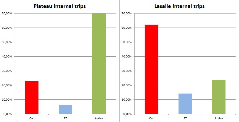
Mode share, for internal trips only
So Lasalle has twice the car use rate as the Plateau, and three times as high for internal trips. The number of transit trips is much closer, but walking and biking take a severe drop.

Exploring the reasons why Lasalle fares much poorer than the Plateau is important to underline the point that, in terms of urbanism, urban design matters. It doesn't suffice to have the same blocks to achieve the same result, the interaction between these blocks are vital.

Why Lasalle is no Plateau

 One of the biggest differences between Lasalle and the Plateau is the street network. The Plateau famously had residential streets going straight to the commercial main street without any detour. Lasalle on the other hand has a street network built to favor speed on the main streets by reducing the number of intersections, and so the porosity of the street network. It also created streets to discourage through traffic in residential areas. In fact, on average there is one intersection every 50 meters (170 feet) on commercial streets in the Plateau, but only one every 250 meters (800 feet) in Lasalle.

Most streets provide no direct path to the commercial street, people have to make detours
There is also the issue of the width of the commercial area. In the Plateau, the commercial "zone" is only about 80-meter wide.


In Lasalle, it is three times as wide, at around 250 meters, with little or no housing therein.

The Newman Boulevard is also a 6-lane boulevard with a median, which is hard to cross for pedestrians, unlike the Avenue Mont-Royal in the Plateau, which adds another barrier to pedestrians and cyclists. The result of this is that there are very few people who reside within 300 meters of any business in Lasalle. Even if you have high-density housing, if it's located beyond comfortable walking distance, you're not much better off in the end. 

This is crucial because the decision to walk is very distance-sensitive. People within 300 meters (1000 feet) of their destination are unlikely to do anything but walk to it. But beyond that, walking mode share falls very quickly. Having residential areas built right next to commercial destinations and having residential areas built at 300 meters from commercial destinations, supposing a density of 20 000 people per square kilometer, is probably the difference between having 10 000 people who would opt to walk and having just 5 000 people.

Lasalle is also not comfortable to walk, as you can see from the pictures above of the typical Lasalle housing, streets are generally very wide, with pedestrians stuck on narrow sidewalks between cars parked on the street and driveways on which cars are sometimes parked, with few trees around. As to the commercial street, it is nothing short of a disaster in Lasalle, with huge parking lots in front of 1-story buildings where each unit tend to be wide but shallow, the opposite of the narrow but deep commercial units of the Plateau.
A view from Newman Boulevard in Lasalle
Avenue Mont-Royal in the Plateau
St-Denis street, also in the Plateau
So not only is the commercial street harder to access, but once there, walking alongside it is a chore, not a pleasure. The presence of plenty of free parking also incites people to take their car, whereas parking in the Plateau is rarely free.

Some commercial malls are also built with barriers separating them from residential areas, like I talked about in my most recent post.

Conclusion

What I hoped to illustrate in this blog post is that good urbanism requires good urban design and to provide an example of the consequences of the barriers and detours between uses and of the dendritic street network that favors vehicular speed over providing direct access and short distances. Despite the Plateau and Lasalle having many basic similarities in terms of design and housing, due to the differences in street network and in the fine details of the urban environment, the walkability of Lasalle is much inferior and results in the dominance of the car as a mean of transport.

So it doesn't suffice just to build dense residential areas or to put them adjacent to commercial areas and providing transit lines along commercial avenues. Design matters.

Bad habits of North American cities: magicking distance from proximity

One fundamental principle of 20th century planning has been use separation, the idea that buildings used for certain purposes must be separated from buildings that have different purposes. Some of these usual uses are residential, commercial, industrial, institutional. Often, cities will have absurdly big single-use zones that are square kilometers in size.

Nowadays in Montréal, we have a metropolitan plan to increase density (simplistically defined as residential density) which results in residential zones taking much less place than before and therefore being much closer to commercial zones than before. Said like that, it seems like a very good thing, after all, density requires proximity to really achieve its potential. Yet, the mentality of use separation and car-centric planning still leaves its mark on newer neighborhoods.

How? Well, use separation in North America has become an art over the years. It's not just about keeping X away from Y in distance as a bird flies, it is also about deploying the magical art of making that which is near, far. An art that employs the street network to make direct paths as rare as possible.

Here is one example of this, in Laval, a suburb to the north of Montréal, near the Sainte-Rose commuter rail station.


You'll note that I identified the grocery, which I personally consider the most important store in a walkable neighborhood. In fact, if I were to make a checklist of criteria for valid TODs, I'd put in at number one:

"There is a supermarket or grocery at the station or within easy walking distance of it, with high-density residential areas within 5-minute walking distance, otherwise AUTOMATIC FAILURE"
Anyway, this area is pretty typical, with a commercial arterial street and residential side streets.

Just to the west of the commercial area, there is a new residential development with quite respectable density, which includes:
Relatively small single-family detached housing

Older semi-detached housing

New town houses built in groups of 3 or 4
Newer semi-detached houses
And some condos to top it all off
So this is some respectable density, and some of it within 10-20 meters of the grocery, great, right?

Except look at that street grid again, there is no direct link between this new neighborhood and the grocery. There is an unbroken fence all along the border between the commercial zone and the residential zone. So all the people who live in the high-density neighborhood have to take a detour by the north, through an inhospitable parking lot or on the sidewalk of a large street with poor enclosure and no buffer from cars to get to the grocery.

You have some housing that are built right next to the grocery, that they can probably throw a baseball on it, but there is a minimum of a 300-meter detour (1 000 feet), or 3-4 minutes of walking distance, in order to get to the front door.

This is a combination of two things.

The first is the psychological obsession with separating uses, even when they are right next to each other, we often build a fence or a barrier between the two to impose detours and make what is near, far. To make sure that they do not mix, no matter how near they are.

The second is a classic street network built all around the car, which may have sidewalks but which is still built with the car in mind. We can call it a "stream to river" model, with the small, sinuous residential streets going nowhere except onto collectors, which are a bit straighter with less stops, which flow onto arterials which have much higher speeds, a limited amount of intersections, most of which with traffic lights to favor speed and fluidity. This street network channelizes traffic onto high-speed arterials and keeps it off the residential streets. So the residential streets are like small, slow streams that flow into progressively faster and larger rivers. And as the arterials are where most of the traffic is and locations around it are the most quickly accessed locations, that's where businesses will want to settle.

The goal of this model isn't to reduce distances. That is inconsequential to the street network. What it seeks to optimize is vehicular speed, residential streets flow quickly onto collectors which flow onto fast arterials.

And indeed, here is an example of this at work, this is the quickest path as calculated by Google Maps:
1,3 km and 3 minutes
And this is the most direct one:
950 meters and 4 minutes
In many cases, the direct path doesn't even exist, like in the case of the newer neighborhood to the west.

So this street network actually works relatively well: people can still get where they're going fast thanks to the high-speed arterials (even when they have the same 50 km/h or 30 mph limit as residential streets), and traffic is turned away from residential streets. So you have speed and traffic-calmed residential streets, what's the problem?

The problem is that pedestrians and cyclists don't go faster on the arterials than on the residential streets. So these detours which don't matter to cars because they can get higher speeds have no benefit to pedestrians or cyclists, they walk or bike at the exact same speed no matter where they are. Worse, the high-speed arterials are often very wide, leading to very uncomfortable walking environments, or biking environments, unless bike paths are provided. Arterials also often lack crosswalks, allowing crossing the street only at rare intersections, where pedestrians need to wait one or two minutes for their signal after pushing the button. This forms a barrier to pedestrian trips in and of itself. Crossing even a moderately sized arterial is often the equivalent of walking another 100 meters or so (300 feet).

So this "stream-to-river", street hierarchy street grid is terrible for pedestrians and cyclists. It seems like a good idea only to people who assume that every trip is made in a car and that other people don't exist, or don't matter if they do exist. And talk about a self-fulfilling prophecy, on such a street network, most trips WILL be made in cars because that's the only mode of travel that is really advantaged by the street grid. Buses that follow the arterial can also be faster, but buses are not good for short trips because of the wait time, the fact is that you're usually better off walking to your destination if it's under 1 kilometer rather than taking the bus.

The result

So what's the result of this? We do have proximity between high-density housing and neighborhood stores, but that proximity is "car proximity", not "pedestrian proximity". It would have been the easiest of things to open up a pedestrian path to the front of the grocery, allowing all residents of the neighborhood to travel pleasant residential areas up to the grocery rather than taking a detour through a long parking lot.

A proper grid is generally best for pedestrians, if you already have a suburban-style street network, opening pedestrian paths to replicate a grid (or quasi-grid) for pedestrians would be a great idea.

Just for comparison's sake, here is a supermarket in a residential area of Obihiro, in the northern island of Hokkaido in Japan. Why Obihiro? Because it's one of the most car-oriented cities in Japan, but even there, walking, even if not that great, is certainly a viable alternative.
The supermarket is marked by the red bubble. Note first how compact its parking lot is and how they integrated the supermarket in the residential street grid rather than creating barriers between uses.
The contrast is striking, whereas in Laval the closest house to the grocery was about 300 meters away, in Obihiro, there are maybe 300 or 400 houses within 300 meters of distance of the grocery's front door, people who are very likely to walk there. They even added a pedestrian path in the rather longish blocks to the south of the grocery, even if it's hard to see on this image. And these are mainly single-family houses of no higher density than the new developments in Laval, in fact the condos are roughly 2-3 times as dense.

Density matters, proximity matters... and street network design matters. Unfortunately, many planners in North America have yet to shake off this mentality of separating uses and of putting barriers between them if they can't simply use distance as a buffer.

Wednesday, October 1, 2014

To setback or not to setback, that is the question

As a kid growing up in a suburb, in a bungalow on a roughly 650-square-meter (around 7 000 square feet) lot, I learned young that the house I wanted in the future was one without a lawn. I thoroughly hated mowing the lawn and saw it as completely useless. Especially the front yard, that I saw as "too public to be an effective private space, and too private to be an effective public space". Yet bylaws made sure every house had to have a large front yard because of a mandated minimum setback, a distance between the building and the curb, and a duty to respect a building line to maintain harmony so that houses' facades are built on one single line.

From the point of view of creating a good cityscape, massive setbacks are counter-productive. Not only do they often reduce density by imposing deeper lots, but they go against the feeling of enclosure that makes walking and even just being in a place comfortable.
Sapporo, a low-rise residential area with great enclosure

Vaudreuil-Dorion, weak enclosure due to large setbacks and absence of mature trees
So, I'd like to ask a question:

To setback or not to setback?

First, what might the point of a setback be? When looking at the front yards of most North American homes, the answer seems to be: nothing. They are extremely rarely used for anything. Back yards are more useful and often house pools, parties with friends and the like, but the front yard is most often an empty space, just a bit of lawn, maybe one or two trees, and a driveway.

However, setbacks do serve some purpose even if they're not actively used.

For one, they provide a space between the street (public space) and the building to protect people's privacy. If you have no setback and you reside on the ground floor, you will be compelled to close the shutters in order to protect your privacy. This is seen especially in France where it's not rare for single-family homes to have essentially no setback despite having deep lots.


The result is that houses are almost built like besieged castles, with windows, at least on the ground floor, shuttered to protect the occupants' privacy. The walls are often bare of details. This is especially true in places where pedestrians are limited to sidewalks, thus being forced to hug the walls of buildings. With shared, narrow streets, this issue is less important as pedestrians can walk farther from buildings and are not forced to walk within arm's reach of the house's front wall.

The second purpose of the front yard is as a public facade. It allows people to participate in shaping the environment, for instance by decorating for Halloween or Christmas, or creating pleasant facades of their houses, like creating a display for themselves, some personalization of their home. I think it may be a very good thing to have in order to create a feeling of community and openness.

So I see the point for a setback for single-family houses, since there is a single owner of both the house and lot, the front yard is theirs to arrange how they see fit. For multi-family houses, setbacks aren't as important, most people tend to live over the ground floor and so do not require a setback to protect their privacy and the status of the front yard as a shared property or as the property of a non-occupant owner means that if there is one of some size, it is likely to be completely unused (a reversed tragedy of the commons if you will).

However that leaves the question about how large should a setback be?

Front yard or buffer?

It seems to me that most of recent setbacks are at least twice as deep as they need to be to fulfill their actual role. Looking at old single-family houses in North America built before the car, we can see that setbacks were much, much smaller, even when lots were very deep.
Burlington, Vermont
Charlesbourg, near Québec City
Ste-Agathe-des-Monts, a village in the Laurentides
Winston-Salem in North Carolina
In all these previous examples, we can see similarities. There is a setback in most cases, but it's about 3 meters on average (10 feet). Many of these houses also have porches as a physical buffer between the public realm (the sidewalk) and the private realm (the house).

 Now let's look at more recent developments:


The setback has basically tripled, from 3 meters to 10 meters on average (10 feet to 34 feet). What's interesting is that, though the space has increased, people will very rarely use that additional space, when they do some work to make their facade look good, they will concentrate on the area right next to their door and leave the front half of their front yard completely bare, or with only one tree.
The owner has planted flowers and shrubbery near the stairs to the door, but left alone all the rest of the front yard, apart from a single tree planted in the middle

What happened?

I think the car happened. This increase in the setback is no longer there to protect our privacy or to provide some space to build a facade, it exists to create a buffer between the building and the traffic on the street. Sometimes, they are used to park cars, but many houses have driveways built not in front of the house but to the side.

But still, cars happened in Japan and Europe too, yet they tolerate much smaller setbacks than we do, why? And why does it seem not to bother them?
Germany

The Netherlands

Sendai, Japan

United Kingdom
What do we do that is different from these countries and that leads us to build these huge buffers?
I think the main reason is that we have frequently built residential streets to the standards of highways, with lanes 3,5-meter wide (12-feet) plus shoulders, which is absolutely ludicrous in areas where there is plenty of off-street parking and therefore cars will only rarely be parked on the street. Shoulders as a whole do not belong in urban areas.

So we have too often designed residential streets as through streets rather than as access streets. They are built to allow easy car movement through an area by providing enough space to eliminate friction with other vehicles and street users. Without friction, cars move much faster, and fast-moving cars are more dangerous and noisier than slow-moving cars. It is natural that we would prefer to be further away from them. On the residential streets of Europe and Japan, cars generally go at speeds of 30 km/h and lower (20 mph and lower) because of the narrow streets and the presence of objects close to the roadway. 

Propose such streets in North America, and many people panic... yet, we have plenty of access streets that are also shared spaces in our cities, with narrow lanes and solid objects surrounding them. Want to know what I am talking about? This:


If this were a public street, it would be illegal, but it's a private access alley to a parking lot, so it's okay! Am I the only one who thinks that with a couple of trees, this would look great?

This entry into a parking lot is less than 6-meter wide, with curbs and fixed objects right next to the travel lanes

The average parking lot alley is about 6-meter (20-foot) wide, with cars right at the extremities, leaving a narrow corridor in which two cars passing each other will have to slow down. This corridor is also shared with pedestrians, making parking lot alleys a shared space. Yet in most cities, proposing 6-meter wide streets with trees right on the other side of the curb, that cars have to share with pedestrians, would likely give a few planners and engineers heart attacks. But these same people would likely have come to the meeting in cars, driven and walked in such "streets" without noticing when they parked their cars and walked to the building.

Granted, there are quite a few accidents in parking lots, but almost all of them involve cars parking or getting out of parking. Otherwise, the area is safe enough that people do not feel afraid of walking through parking lots, else no one would be driving anywhere!

Conclusion

Human-scaled setbacks are probably a good design for single-family homes in order to provide more privacy and a customizable space to the owner to allow them to participate in making the public realm more appealing, including participation in community celebrations (Halloween, Christmas, National days, etc...). But in most North American cities, most setbacks are much too deep as their true purpose is to create a buffer between traffic on the street and where people live. Much could be gained by narrowing the streets to make them access streets rather than through roads and reducing by half or more the current setback. Though hard to apply to built areas (well, you can narrow streets, but reducing setbacks would involve rebuilding every house), this needs to be taken to heart for new developments.

If anyone says such narrow streets are unacceptably dangerous, point out to parking lot alleys which are designed in almost the exact same way, but which no one seems scared of.